Wherever the circles of car infrastructures have been drawn onto the map of the city, invisible fortress walls have arisen. Disguised as arteries conveying essential life blood – but still as inaccessible as the stone walls that once guarded the town – the volatile nature of circular traffic belts surrounding a city makes them a site of contradictions. Decisive circular traffic interventions inserted into the periphery of the historical core of a city not only separate the old and the new, but equally the meaningful and the mundane. Moreover, the concept of a circular route on the edge of the old town holds a different interpretation on the European continent than in the British Isles, and especially in the southern African context. The numerous settlements under the influence of the Anglosphere have different interpretations to the development and design of the ring road concept. In the South African urban context, several variations of the ring road exist – and in the capital city, Pretoria, it is both the site of decisive interventions and abrupt isolation. What makes this intervention unique compared to its counterparts in Europe and Britain?
This paper investigates the southern African interpretation of the non-navigable ring road as an imported planning model. In 1948, the town planners and the national government approved the Pretoria Traffic Plan, acting on the recommendation from the report published by the British town planner, Sir William Holford, and subsequently set about the dedicated goal of modernising the capital city. One of the principal recommendations of this report stipulated the regulation of traffic through the city, which proposed the removal of vehicular traffic from the historical city centre in favour of a more complex alternative system to the existing road network of Pretoria. This ring road underwent several variations, but its contradictory effect forever changed the urban tissue – and thus became both the site of linkages and segregation.
The overabundance and the increased, unavoidable presence of more advanced and modernised motor vehicles in the mid-20th century forever transformed the human experience of movement and circulation in the modern city. One only needs to look at Le Corbusier’s conceptual 1920 Plan for Paris, where the architect proposed replacing the Parisian boulevards with uniform and monotonous towers in a park, linked by high-speed traffic-carrying roads. As if to reiterate this sentiment, the early Modernist architects’ futuristic aspirations afforded us the infamous description of modern architecture as a machine for living, which almost perfectly exemplifies and supports this analogy – to understand the obsession of the modernised infrastructure that became dedicated to the car-centric character of the late 20th century cities.
Humanity’s mechanical mind and its penchant for imposing order and hierarchy over perceived chaos was drawn to the imaginative quality of the city of the future. This modernised arcadia imagined the city as a beacon of light and convenience, drawing to its commercial and capitalist centre strings of single-minded motors flowing endlessly to-and-fro along the endless paths of tar and concrete, like moths to a flame. Perhaps the best example of this fascination that the city of the future inspired in the early 20th century Modernists and industrialists can be traced – among other similar period-appropriate futuristic visions – to the 1939 New York World’s Fair, and even more significantly its unveiling of the iconic General Motors “Futurama” Pavilion.1 The exhibition, which was designed by Norman Bel Geddes (1893–1958), featured an intricately detailed scale model presentation of a utopian vision for a futuristic metropolis populated by sleek skyscrapers with megalomaniacally scaled open spaces, an emphasis on the display of monumentality and progress, all fronted by organised rows of automated highways. Needless to say, this presentation captivated the imaginations of its varied audience of visitors, planners, industrialists and designers alike, and would continue to influence the future of town planning, transportation and infrastructure development. The popularity of the exhibition proved so widespread that the US president, Franklin D. Roosevelt, invited Bel Geddes, as Futurama’s designer, to advise on the nation’s transportation issues, eventually leading to the developments launched by the Federal-Aid Highway Act of 1944. The real-world applications of these new mega-engineering projects would prove quite different from what was once imagined, and thus our modern cities have inherited some unique agathokakological2 modern monolithic transportation structures that have mutated the urban landscapes.
Ring Road vs. Ringroad
It is thus first necessary to articulate the difference between a ring road and the ringroad. That “lord of the ringroads”, the Vienna Ringstraße, the most quintessential urban feature of Central Europe is an example of the ringroad.
An urban pedestrianised and infrastructural element, it is the dedicated and deliberate development of the area once occupied by the medieval walls and glacis of the imperial Hapsburg city. The interest in uniting the city with its more modern suburbs was already articulated during the reign of Empress Maria Theresa around 1760. However, it was only at the command of Emperor Franz Josef I since his momentous “Es ist meine Wille” speech in 1857, that the demolition of the outdated Viennese military defences was ultimately realised. The urban void soon gave way to the grand boulevard that became the ubiquitous symbol of Viennese cultural and public life. Originally, Franz Joseph I dictated the exact size and width of the proposed public road, as well as the exact geographic positions of the new public buildings along the boulevard. The area was intended to become the site of prestige and celebration of the splendour of the Austro-Hungarian Empire and its seemingly undisputed absolute monarchy. On a strategic security and authoritarian level however, it should also be noted that these widened roads and parks of the boulevard took clear security inspiration and notes from Baron Hausmann’s Paris and the French Emperor Napoléon III – wherein the widened roads actively discouraged the construction of revolutionary barricades and blockages of streets as well discouraging the formation of communards. Ironically, considering the origins for the work “boulevard”, which once meant the flat surface of a defensive rampart, the word would come to define the public walking space next to the old town defences. Nevertheless, the Ringstraße [ringroad] proved to be a success for public meandering and has since then become iconic of Vienna and other significant Central European cities. In summary, the Central European concept of the ringroad could be considered as a connecting element between the medieval town and the later exterior neighbourhoods established outside the old city walls.
In contrast however, ring roads (I propose the separation of the two words, in order to promote greater clarity in definition, since it is not a direct translation of the German word Ringstraße) are the oft-criticised, more modernised and vehicular-oriented urban infrastructural phenomena that have become synonyms for delineating the periphery of many continental European, North American and British cities and feeding these urban centra with endless commuters. These circular roads are often described through a variety of nomenclature, depending on the obscure function that it performs. Ideally, the purpose of these ring roads is to encourage a reduction of traffic volumes throughout the adjacent urban centre and provide motorists with alternatives routes of travel that bypass the central core of a city.
In the context of the Anglosphere, similar ideas about circular routes and the allure of ring roads appeared at various times during the early to mid-20th century. Of particular note is the 1944 Greater London Plan developed and championed by the architect, urban designer and town planner, Leslie Patrick Abercrombie (1879–1957). This bold strategy proposed the creation of five ring roads for London – including the inner Motorway Box that would ultimately result in the displacement and resettlement of nearly half a million people, nearly 40% of which would be from London’s traditionally impoverished East End, in newly established “satellite towns”.3 This scheme was never realised.
However, the rampant and widespread destruction wrought by the Second World War, actively encouraged town planners and other city authorities to develop new strategies for the post-War reconstruction era. To wit, the British city of Coventry became an important and significant example of radical rebuilding and “progress” during the post-War British reconstruction phenomenon.4 The city had been almost razed to the ground after the now infamous 1940 Luftwaffe bombing campaign, which saw nearly two thirds of the former industrial-centric and former medieval city destroyed. Coventry’s first city architect, Donald Gibson (1908–1991), saw the destruction wrought by the bombs as a chance to completely renew the city’s overcrowded and chaotic core.5 Indeed, the young architect had even produced a redevelopment scheme for the city before the War, but could later adapt it for the needs of the reconstruction. The resulting new design of the central area of Coventry proved then to be an example of comprehensive planning and design that promoted unique strategies to deal with issues of pedestrian and traffic circulation and parking. In addition to the aforementioned questions, the planning proposals also made provisions for, among others, new commercial quarters and market, a large civic quarter, municipal offices, leisure spots and educational facilities that were concurrently integrated into a unified whole.6 The replanned centre of Coventry became internationally acclaimed as the archetypal post-war boom town.7 Gibson’s designs for the town were considered futuristic, relevant not only for the immediate needs of its inhabitants, but also the future residents of Coventry.8 In parallel, the chief architect hoped that these proposals would transform the town into a substantial regional capital.9 Ultimately, it was the contemporaries of Gibson, including one William Holford, Baron Holford (1907–1975), who unanimously claimed that: “Coventry – amongst all of the badly war damaged towns in Britain – has managed to have achieved the strongest measure of unity and integrity in its reconstruction”.10
Importing the Urban Strategies into South Africa
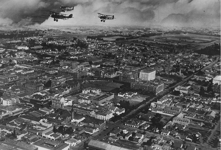
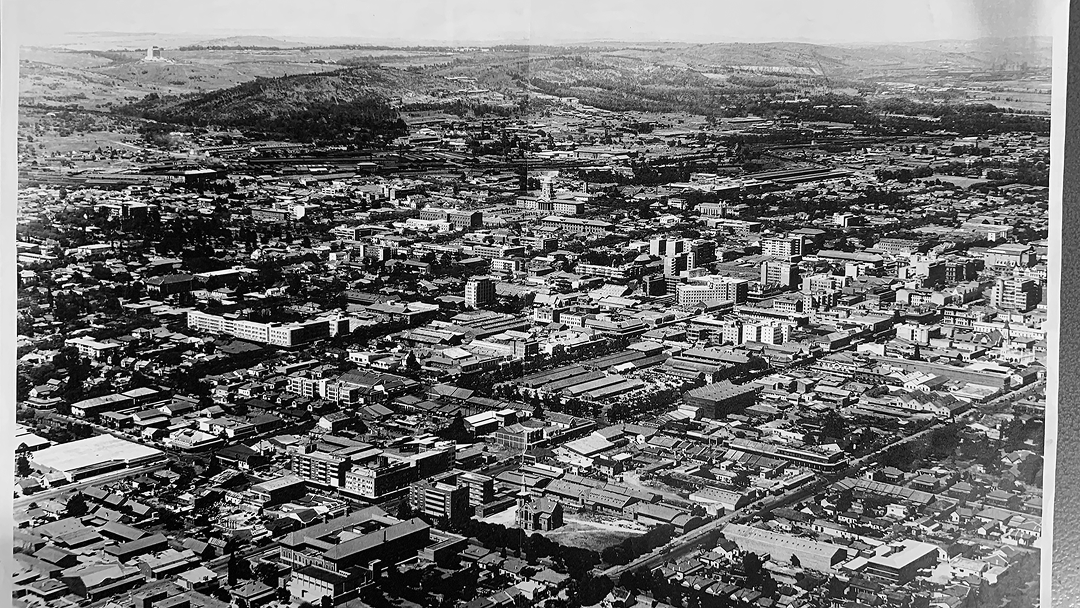
Elsewhere in the global sphere of the post-War era, the ring road concept made its debut in Pretoria in southern Africa when the city council and town planners department began to make a concerted effort to establish the city’s image as the capital of the Union of South Africa. Then till a subsidiary of the British Commonwealth, was undergoing several unique transformations. Firstly, the ultra-nationalist and conservative political party – the National Party (NP; 1917–1997) – won the 1948 general election, upon which it immediately began implementing its policies of racial segregation and the associated “morality laws”.11 Secondly, South Africa – with specific mention to its administrative capital, Pretoria – would come to experience its first period of economic and population boom since the Boer War and other tumultuous political and social events from the beginning of the 20th century.
The growth of Pretoria as a capital city is often considered as a rather unbalanced process. Nearly thirty years prior to the 1948 election, the whole population (implying both Black and White) of the town was about 68 000 residents. By 1946, the municipal population had grown to 170 000 residents and a further 75 000 residents in the immediate surrounding suburbs.12 The continued and unconstrained rapid growth of the municipal population placed a greater strain on the city infrastructure and its image as the capital of the Union of South Africa. Hence the city council was spurred into action to address the need for a definitive planned future expansion and growth of the city, including the associated suburban areas.
To clarify the context: Pretoria was not unlike other modernising cities of the mid-20th century that attempted to deal with addressing the urgent need for improved urban hygiene and appropriate modernised sanitation infrastructures, and hence public sanitation projects undertaken by the city council and policymakers alike, which would eventually impact the density of the inner cities for the later part of the 20th century. For example, in an effort to reduce the strain on the council to provide the residents with adequate housing and ensure regulated development of the historical city central area, the city council of the early 20th century encouraged the establishment of peripheral suburban areas. Accordingly, commuters would thus have to travel long distances from the outlying suburbs to the city central area for work and commercial necessities on a daily and regular basis. This lack of foresight by the Pretoria Municipality a decade prior to the late 1940s pressured the council to address the ever-increasing number of vehicles entering the city, as well as hastening to provide adequate parking and unrestricted travel lanes. But even more pressing to the authorities was the issue of having to upgrade the image of Pretoria as the premier seat for national and regional administration.
South Africa, situated on the perceived fringe location of the developed world, constantly looked to other parts of the world for guidance in developing its own built artefacts. As such, Pretoria town planners considered the development of Coventry in Britain as a suitable comparative example for developing similar reconstruction solutions in Pretoria. Additionally, there was Baltimore in the United States that was also cited regularly as a comparative urban example, with special attention paid to the city’s “Downtown Plan”, which the South Africans deemed to be the most advanced and workable solution for a possible Central Area redevelopment.13 Ever since the formation of the Union of South Africa in 1910, Pretoria had served as the administrative capital of the new unified nation. However, the capital was not an industrialised urban centre, nor the financial powerhouse that Johannesburg had become since the first discovery of gold and diamonds in 1866. It was still predominantly an administrative seat of government, only becoming decidedly more industrialised and modernised in the mid to late-20th century.
Around 1944, the city council and other stakeholders commissioned a report on the state of the capital. This process coincided with the capital city acquiring its first real town planning scheme – a planning instrument that remained intact up until 1973.14 This was a marked attempt to determine the most appropriate course of action forward, concerning the future of urban and spatial development in the capital. Unfortunately, the original full report was never published and made available to the public and is presently accessible as a marginally discussed footnote in more recent published research documents. It is unknown if any of the recommendations from this report physically manifested within the greater urban context, though the report was amended in 1948–1949.
In 1948, (then professor) Sir William Holford, who was a South African-born British town planner, was appointed by the South African government and the Pretoria City Council and commissioned to produce a report on improving and redeveloping the Central Area of Pretoria. Contextually, Holford had by this time made his career as one of several British architects and town planners to have undertaken several significant post-War reconstruction works in London. His academic history is just as impressive: in 1925, the young architect first worked in an architect’s studio in Johannesburg where he came across a prospectus from the University of Liverpool. During his subsequent move to Liverpool, he was introduced to town planning practices, and by 1930 his winning project entry to the British School in Rome secured the young architect a position at this prestigious institution.15 Holford’s experiences in Europe and his interactions with the celebrity personalities of CIAM undoubtedly shaped his interpretation of the rising importance and possibilities of town planning and its substance. In 1933 Holford was appointed as a lecturer at the University of Liverpool and by 1937 he had succeeded Patrick Abercrombie as the Professor of Civic Design. Having been intensively involved in the post-Second World War development by the new ministry of town planning in Britain, Holford was instrumental in the drafting of the Town and Country Planning Act of 1947.16 By 1948, Holford again succeeded Abercrombie, this time as Professor of Town Planning at University College London.
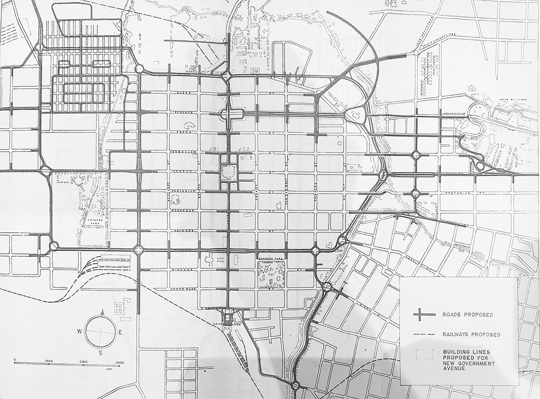
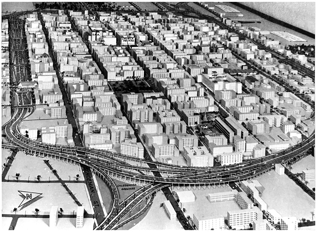
Given that town planning was still in its relative infancy in South Africa, it was a boon to the South Africans to have such a prestigious and significant Commonwealth town planner, with experience in the post-War reconstruction and town planning policies, involved with their own ambitions and development schemes.17 From 1947 to late 1948, Holford compiled a report on the state of the capital city, with a specific reference to developing the central city area. The report considered also the social and cultural conditions of the capital: it was Holford who recognised and described the trend that 1 in 5 Pretoria residents were involved in Government services – a trend that would remain consistent.18 This phenomenon thus informed the recommendation by the report to group government offices and ancillary functions together in the spirit of efficiency and proper civic design.19 The report included several plan drawings illustrating the concepts proposed by Holford, which he collected as the description on the growth effects on the Central Area. Pretoria, with its largely mundane and regularly shaped traditional urban grid, lacked a sense of visual identity and spatial hierarchy – a phenomenon that Holford addressed as necessitating a clear definition of the Central Area. Ideally, this new and clearly defined district should be large enough to be supported by functional supplementary commercial, office, warehouse and public and civic buildings.20 Additionally, the report recommended the revision of the urban structure to introduce height and density zoning considerations within the Central Area.21 However, perhaps the most influential part of the report and its recommendations was the proposed transformation of the existing road patterns in the urban structure. Holford suggested that the Central Area be defined by a physical ring road limiting direct access, which would simultaneously act as a relief system for all local through-way traffic.22
This recommendation for Pretoria undoubtedly came after the initial successes of and interest in the Rebuilding Coventry paradigm. In the design of the ring road, Holford considered it to serve several purposes. The Pretoria Central Area ring road would provide a system of radial and alternative routes designed to alleviate vehicular traffic passing through the city towards outer destinations, rather than providing access to buildings, as well as encourage the better distribution of peak hour traffic from the surrounding suburbs to the city centre, and vice versa. Additionally, this inner ring road would act as a natural boundary between areas which were identified to be central to the image of the city as a whole, and those that were considered sub-central and speciality zones.23 More importantly, this proposed inner ring road was intended to support the existing public transport network, and to act as far as possible as a traffic exchange. These intersections of the ring road were envisioned to connect close to the railway terminals and introduce long-distance bus services and stations.24
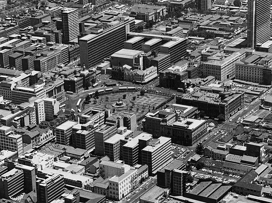
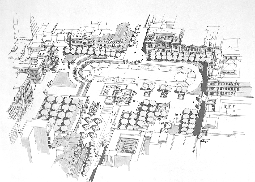
Of particular note in the submitted report is that Holford made it clear that Church Square (the main square and public space of the city) – then serving as a bus terminal – would be drastically altered and have its character and see its character redesigned to better serve pedestrian traffic and public functions.25 This proposal was initially polarising, as the city traffic department preferred to use the space as an important transport node, yet Holford’s recommendation was more in line with restoring the dignity and significance of the historical public square.
Additionally, Holford further expanded on the idea of supporting the growing number of government and civic workers in the capital city through proposing the grouping of these offices in a dedicated district. Ever since the British-dominant administration of the Union of South Africa occupied the capital, the primary government offices were moved from the centre of the city to the hill overlooking the city. Sir Herbert Baker (1862–1946)26 designed and built the Union Buildings in c.1910 on the periphery of the city core. Conceptually, this structure broke with the significant “urban hinge” motif of the eastern axis of Church Street that had come to develop within Pretoria since the late 19th century. Holford’s proposal was to develop Struben Street, (just further north of Church Street) which connected the historical Central Area with the new government offices at the Union Buildings, into a Government Avenue.27 This allowed for buildings designed and constructed along this avenue to have adequate spaces for decorative open spaces as well as the development of additional processional routes.
Therefore, one can summarise the core intentions behind the Holford Report as the first approach toward clearly defining the functional classification of the existing road structure and introducing specific zoning areas throughout the Central Area of Pretoria.28 Although Holford was an ostentible admirer of Le Corbusier and his radical town planning ideas, his proposal for Pretoria was generally a more conservative and intentionally civic-minded consideration, not only a purely traffic-oriented scheme.29 Moreover, Holford’s detailed report introduced a much-needed guide for the South African town planners to assist with developing zoning guidelines and building height restrictions for the city and the Greater Pretoria district. Holford did, however, recommend that additional and more accurate traffic surveys be conducted before his proposal was to be implemented. Ultimately, the report along with its recommendations and concepts, published by Holford, were generally well received by the City Council – and would come to be adopted in some cases by the later schemes and infrastructure developments.30
However, as was the visible and repetitive trend in South African politics and modernising development schemes, a significant delay persisted between concept and a real-world application. Even though Holford frequently visited South Africa and was consistently invited to give lectures to speak with architects and town planners alike, on one occasion even being awarded an Award of Merit from the Transvaal Chamber of Architects, his practice never took root there.31
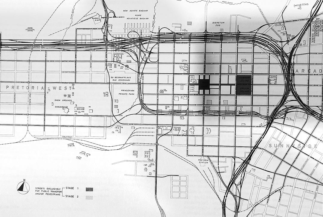
By the 1960s, there was still no real permanent solution to the traffic problems in the capital city. The City Engineer’s Department of the Pretoria City Council proposed a new and simpler ring road for the Central Area with six arterial roads collecting and distributing traffic to and from the Central Area.32 This proposal, dubbed the Pretoria Traffic Plan, was based on traffic survey data from 1956 and aimed primarily at developing a road system in the capital city which would provide smooth traffic flow.33 Additionally, this document focused on solutions to the projected issues for the anticipated 1981 traffic congestion. Significantly, however, this plan continued to develop Holford’s earlier proposal to grant special consideration to the Central Area. It needs to be recalled that a noticeable trend for these British-influenced development plans was the careful consideration awarded to establish new civic centres for the urban sites.34 In blatant contradiction of the Holford report, this plan proposed to upgrade and transform one of the existing roads into a traffic collector and cut through the urban grid, rather than work with the existing road patterns. Additionally, the City Engineers proposed to redevelop several of the roads in the Central Area into dedicated one-way routes.35 The sole focus for this detailed report was the development of an improved and dedicated mass transportation service in the capital city and the greater outlying region.36 The engineers proposed using Skinner Street as the southern boundary for the Central Area, a decision hotly contested by both stakeholders and the Chamber of Commerce alike. Criticism of this specific road proposal stemmed from the fact that this boundary would then place two schools within the Central Area, an unpopular opinion.37
Significantly, the City Engineers developed a bold new strategy that would further influence the decisions and recommendations that followed the 1960 Pretoria Traffic Plan. One of the alternatives to the ring road concept that the engineers proposed was the development of a Throughway System Plan.38 The throughway or freeway (as described by North American planners and engineers) was a road system intended to provide a noticeably high level of traffic service without connecting to any of the immediate local arterial roads. Accordingly, this type of road allowed traffic to pass along at higher than normally customary speeds, and was similarly either elevated above the immediate ground, or depressed below the surrounding urban structures.39
The City Engineers were diligent in keeping with the original delineating concept of Holford’s ring road scheme and conforming to its intentions. However, the updated information from the traffic surveys inspired a different approach to proposing an engineering solution.40
The 1960 Pretoria City Council, in granting urgent consideration to the recommendations from the Engineer Department’s proposals and the concerns of policymakers and their associated stakeholders, rapidly commissioned an additional two successive proposals for a solution to the anticipated future traffic problems of central Pretoria.41
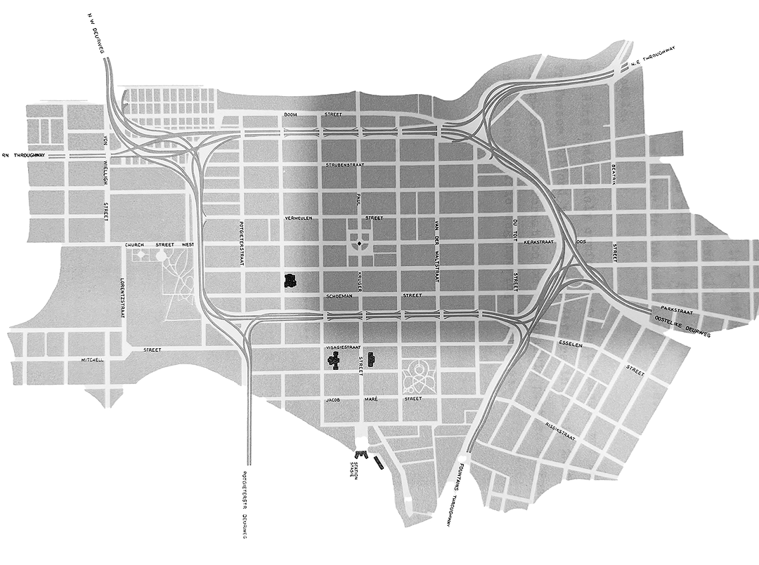
In 1965, the Telford Commission, under the guidance of Alan Telford (1911–1976) made recommendations to the Pretoria City Council concerning the traffic proposals.42 According to their findings, the accessibility of the Central Area was vital – ultimately echoing Holford’s 1949 concept and proposals – and made provisions for alternative east-west and north-south routes that would follow the visible and natural edges of the Central Area.43 Not long after the publication of the findings from the Telford Commission, the City Engineers again produced a new proposal. The 1967 Freeway Scheme demonstrated the South African state’s lust for high-speed modern monolithic structures that would dissect the city centres. The external consultants who compiled this report were content with further exploring the recommendations from the 1965 Telford Commission report, and as such an alternative amendment was produced.
The 1967 scheme illustrated the distribution of essentially long-distance traffic in the Central Area along a primary north-south street on the eastern edge of central district, and primarily shorter-distance (or localised) traffic along the east-west line along the northern boundary of the Central Area. This report was also one of the first documents that clearly defined the role of the local government and the relevant statutory bodies. What set this planning instrument apart from its predecessors – excluding Holford’s own report – is that it was conceived as a project that integrated both architects, town planners and traffic engineers into a single cohesive panel. A practical solution, it resulted in a document that not only considered the effectiveness of engineering solutions but married these structures with architectural aesthetic considerations.44
Accordingly, Roelf Botha, the architect and town planner that was involved in the committee was responsible for setting out the conditions that envisioned connecting the various urban greenery spaces along the Central Area periphery with the freeway structures. Recommendations were made that urged any future amendments and surveys to include realistic strategies to further integrate the green spaces into the freeway framework.45 Ideally, the report promoted the idea that the new freeways would stimulate additional enhanced development on the edge conditions of the Central Area. It should be noted that the Freeway Scheme considered the point of interaction between the urban structure and the now-canalised Apies River to be the principal position for the major north-south arterial route. Thus, the proposed scheme worked in a more harmonious manner with the natural landscape and historical city structure.
The successive assembly of commissions and committees (a stereotypical South African phenomenon and staple of national criticism) would continue to produce conceptual frameworks and plans for the capital city well into the 1990s, without really producing anything physical. It was not until the early 1970s that an alternative approach and realistic project scope came to exist. By late 1973, Pretoria received its latest and more modernised planning instrument, when the City Council appointed external consultants to draw up a document that would become the Pretoria Policy Plan.46
Essentially, this Policy Plan was to become the first phase in the formulation of a Master Plan for the city as a whole.47 The aim was to establish a clear and definitive policy framework wherein further future planning for the capital could take place. Approved in 1973, it was noted for the strong Garden City influence that underpinned the theoretical planning and its associated thinking processes.48 This specific regulatory and analytical document considered Holford’s initial city image concept as a core concept, and thus developed the successive proposals following the 1949 report into an actionable project. The key insights from this study included the establishment of several significant functional frameworks for potential future development.
This Policy Plan integrated Holford’s ring road concept and developed it according to the successive traffic surveys and modernised engineering structures. Essentially, the consulting committee further expanded the practical considerations of the 1967 scheme into a more holistic urban solution, thus laying the groundwork to assist the City Council in obtaining the relevant permissions and authority to execute the project. The planning considerations for the Central Area built upon Holford’s idea of a strong and recognisable city image, supplemented with adequate public open spaces, urban greenery and a clear separation of vehicular and pedestrian grading and traffic.
It must be understood that these developments, although seemingly ambitious and carried out with genuine good intentions, occurred during the heyday of the ultra-conservative nationalist government’s dehumanising segregationist policies. In the case of Pretoria, with its strictly enforced segregationist policies of the 1950s and 1960s, the freeways were an undisputed covert attempt to further enforce the separation of races and ensure the hidden-in-plain-sight physical barriers between the capital city residents. The agathokakological nature of the ring roads and freeway schemes, including their support policies, both connected the capital and its Central Area to the greater southern African network, yet simultaneously overtly removed and excluded Black and Asian residents from the city. For the town planners and policymakers, the Apartheid laws allowed the authorities to indiscriminately draw lines of infrastructure over neighbourhoods and legally forcibly remove the affected communities. Thus, similar to the great stone city and fortification walls of the old world, freeways became the ultimate tool to separate and exclude unwanted groups. A system of fortifications, wrapped in a sleek and modernised façade that declared progress, but still performed as the castles of old.
At least the South African bureaucracy is nothing if not consistent, as the persisting gap between concept and realisation often remains unfulfilled. Focused development of the new freeway feeder roads only started later, around 1992, by which time the political climate had changed – as well as the needs and image of the Central Area.
Conclusion
The Ringstraße [ringroad] from Central Europe had a vastly different concept and functional purpose, not to mention the planning context within which it was developed, compared to the later manifestation of the more modernised vehicular centric ring road. The South Africans managed appreciate and study the functionality of both systems. By a series of coincidences, it was a South African-born architect and town planner who proved instrumental in disseminating the ideas of continental Europe and the Anglosphere to southern Africa. Yet Holford’s plan for Pretoria was more complex: arguably, he was able to learn from the lessons in the reconstruction of Coventry, and London, and develop a more nuanced solution for the South African context. However, it must be understood that Holford’s proposal was produced without the support of an up-to-date traffic survey. In defence of the architect, one must add that often the bureaucracy and City Council were either too tight-fisted or incompetent to realise even parts of the ring road proposals. If we consider this radical network transformation of Pretoria and its Central Area through the lens of Solà-Morales’ concept of flows,49 then it becomes clear that the city is again a victim of circumstance. Through the insertion of the circular transport motifs, the town planners became confronted with the limitations of segregationist policies, and the hinderances of Modernist planning philosophies. Additionally, the motor vehicle radically transformed the way that we think of city planning and access. In essence, the obstacles that planners and engineers alike faced were predominantly brought about by the process of urban decentralization and incoherent planning policies.
Much like the Futurama exhibition of the 1939 World’s Fair in New York, the Pretoria freeways that were envisioned around the city also formed a unique gestalt: building designs shaped by incoherent influences, yet with certain elements of order and hierarchy that came to be established, thus forever changing the image of the city as a whole. In the end, present-day Pretoria, is one byproduct of the failed or incomplete experimentations of the Modernist era.
COSGROVE, Ben. 1939. ‘The World of Tomorrow’: Scenes from the 1939 New York World’s Fair. Life Magazine, 30 April 1939, 21, pp. 21–43 [online]. Available at: https://www.life.com/history/1939-new-york-worlds-fair-photos/ (Accessed: 6 July 2024).
The term: ‘Agathokakological’ defines a concept which is simultaneously both good and evil.
BOYS SMITH, Nicholas. 2024. How Coventry beat Paris and London on the road to Future. Building Design [online]. Available at: https://www.bdonline.co.uk/opinion/how-coventry-beat-paris-and-london-on-the-road-to-the-future/5128541.article (Accessed: 6 August 2024).
LARKHAM, Peter, J. 2020. British Urban Reconstruction after the Second World War: the rise of planning and the issue of non-planning. Architektúra a urbanizmus, 54(1–2) pp. 20–31. doi: 10.31577/archandurb.2020.54.1-2.2 (Accessed: 6 September 2024)
Boys Smith, N., 2024.
BRYANT, J.D.R. 1963. The consideration of a plan for central Pretoria within the framework of the Pretoria Traffic Plan. Diploma thesis. Faculty of Engineering, University of Pretoria, p. 26.
SAUMAREZ SMITH, Otto. 2020. In defence of Coventry’s post-war architecture. Apollo, 21 September 2020 [online]. Available at: https://www.apollo-magazine.com/coventry-post-war-architecture-heritage/ (Accessed: 6 August 2024).
LAWSON, George. 2020. Built perspective [online]. Available at: https://builtperspective.wordpress.com/ (Accessed: 6 August 2024).
Lawson, G., 2020.
Bryant, J.D.R., 1963, p. 26.
The basis for system that eventually became known as Apartheid.
HOLFORD, William. 1949. Report on the Town Plan of Pretoria: with special reference to the Central Area and to amendments of Scheme no. 1 of 1944. Unpublished report, p. 7.
Bryant, J.D.R., 1963, p. 157.
VAN BILJON, Louw. 1993. Pretoria: genesis and the successive layers of its evolution. Planning History, 15(2), pp. 37–43.
CHERRY, Gordon and PENNY, Leith. 1986. Holford: A study in architecture, planning and civic design. London: Mansell Publishing Ltd, p. 23.
“Lord Holford”. The Times. 20 October 1975. A heavily abridged summary of the Act is thus provided: the town and country planning act of 1947 was purposefully designed to establish an enforceable legal procedure to obtain permission to develop property or land parcels. Ownership of land no longer constituted as a basis for development.
VILJOEN, C. prof., KRUGER, P. W. B., et al. 1972. Pretoria policy plan. Unpublished report.
Holford, W., 1949, p. 8.
Holford, W., 1949, p. 9.
Holford, W., 1949, p. 9.
Holford, W., 1949, p. 9.
Bryant, J.D.R., 1963, p. 23.
Bryant, J.D.R., 1963, p. 25.
Holford, W., 1949, p. 9.
Holford, W., 1949, p. 13.
Coincidentally, Baker was also on the committee of the British School in Rome, during which time Holford was in attendance there in 1930.
Holford, W., 1949, p. 13.
VILJOEN, C. prof., KRUGER, P. W. B., et al. (1972). Pretoria policy plan. Unpublished report, p. 96.
Bryant, J.D.R., 1963, p. 23.
Bryant, J.D.R., 1963, p. 23.
Cherry, G. and Penny, L., 1986, p. 228.
Viljoen, C., Kruger, P. W. B. et al., 1972, p. 96.
A traffic plan for the City of Pretoria. January 1960. City Engineer’s Department.
Larkham, P. J., 2020, p. 23.
A traffic plan for the City of Pretoria. January 1960. City Engineer’s Department, p. 19.
A traffic plan for the City of Pretoria. January 1960. City Engineer’s Department, p. 19.
Bryant, J.D.R., 1963, pp. 29–31.
A traffic plan for the City of Pretoria. January 1960. City Engineer’s Department, p. 24.
A traffic plan for the City of Pretoria. January 1960. City Engineer’s Department, p. 24.
A traffic plan for the City of Pretoria. January 1960. City Engineer’s Department, p. 30.
BRUINETTE, KRUGER, STOFFBERG & HUGO. 1967. Pretoria: Freeway scheme 1967. Unpublished report to the Pretoria City Council.
Van Biljon, L., 1993, pp. 37–43.
Viljoen, C., Kruger, P. W. B. et al., 1972, p. 97.
Viljoen, C., Kruger, P. W. B. et al., 1972, p. 97.
Bruinette, Kruger, Stoffberg & Hugo, 1967.
Van Biljon, L., 1993, p. 42.
Van Biljon, L., 1993, p. 42.
Van Biljon, L., 1993, p. 42.
Flows, or the form of movement is not associated with a physical form in the urban environment, but rather with that of a dynamic that can either alter or reinforce the nature of an urban phenomenon. Ideally this section references and describes the networks, meshes and staccato movements that correspond to noticeable motifs within the built environment. See: DE SOLÀ-MORALES, Ignasi. 1997. Present and Futures: Architectures in Cities. Thresholds, 17, pp. 18–25.
DOI: https://doi.org/10.31577/archandurb.2024.58.3-4.12

This work is licensed under a Creative Commons Attribution 4.0 International License