
Though several attempts were made to create the Budapest Green Ring, it was never realized, keeping the green spaces of the city mutually isolated. Following 19th-century military innovations and the change in the position of traditional defenses, a rebirth occurred of the areas between the historic city center and the outer, with the development pattern of this transitional zone between the old city and the outskirts revealing unique tendencies among European capitals. This paper aims to study the green surface development of Budapest in the context of innovative international green infrastructure development strategies.
Budapest, like many cities around the world, confronts an increasing loss of green areas, either due to the shrinking of existing parks and institutional gardens within the city fabric or the opposition to considering green surfaces around the city as a potential for further expansion, land for further building. This phenomenon is not a new problem; it roots reach back to the Middle Ages when the first expressions of concern emerged about urban sprawl and the loss of green spaces.1 Later, as the Industrial Revolution of the 18th century led to a significant increase in the population of urban settlements across Europe, the organic densification of the urban tissue caused the public health conditions in cities to deteriorate dramatically.2 Water and air pollution, the spread of epidemics and the lack of green spaces eventually forced city leaders to develop new, more sustainable urban development strategies.3
Since then, the main goal of urbanists and landscape architects has been to control the unrestrained expansion of cities, define possible frameworks for conscious development that preserve green areas, and integrate them with social and economic demands in the interest of maintaining a liveable environment in urban settlements. Although public health problems have become more manageable in some respects, we face still newer challenges, such as the effects of climate change and the increasing frequency of natural disasters.4 These facts confirm the key role of green spaces in improving the physical condition of the city and contributing to a liveable urban environment.5 In addition, it is increasingly apparent that green spaces have a significant impact not only on physical health but also on mental well-being.6
To understand Budapest’s current green-space problems and their possible solutions, we must first understand the question in an international context. After examining how other cities have addressed the challenges of preserving and expanding green spaces since the Industrial Revolution, we then compare these instances with Budapest’s development from the mid-19th century to the present. After analysing the unrealized urbanist and landscape architect visions of Budapest’s green surface system development, we describe what answers the current city government might offer to preserve and expand the green spaces.
International System Strategies for Green Space 19th-Century Tendencies
John Claudius Loudon (1783–1843), in his 1829 essay, outlined a pioneering theory of urban planning that focused on green spaces, or “breathing spaces”, a concept conceived to mitigate the rapid expansion of cities and its negative effects – overcrowding and polluted air. Loudon saw green spaces not only as an aesthetic element but also as a vital support for the health and well-being of the population.7 At the heart of Loudon’s theory was the model of a concentric ring city, in which built-up areas would be separated by half-mile-wide green rings, forming quasi-rural areas that would provide fresh air, recreation, and leisure activities for city inhabitants. Residential areas would have been located between the rings, with strictly only residential buildings, excluding public institutions, squares, or markets. A half-mile park in the city’s center would have housed government buildings.8
The dream of Emperor Napoleon III’ (1808–1873) was for Paris as a modern, imposing capital that reflected the power of his empire. To achieve this goal, improve environmental quality, and ease the burden of an unhealthy cityscape and cumbersome transportation, he commissioned Baron Georges-Eugène Haussmann (1809–1891), who redesigned Paris between 1853 and 1870 to match his ambitious ideal.9 New avenues and urban axes were built by demolishing the existing city fabric to improve traffic flow and reduce congestion. Inspired by these interventions that transformed the city’s structure and radically changed the image of Paris, a new architectural tendency rose, the “Haussmann style” characterized by ornate façades, uniform building heights, and trees lining the avenues.10 The Hausmann concept defines the non-built-up land around Paris as the “zone non aedificandi” for further development of a greenbelt, and incorporated the creation of new tree-lined streets and the formation of new public parks, where the tree-plantings not only served aesthetic purposes but also helped to reduce dust and improve the microclimate. The large parks outside of the city centre, such as the Bois de Boulogne and the Bois de Vincennes, along with the smaller parks in the historical centre were also ideas of Napoleon III. Although Haussmann was sceptical about the parks, he acknowledged that green spaces improved environmental quality. In turn, the parks proved extremely popular with Parisians and the intervention became one of the regime’s most enduring achievements, improving urban air quality and making the environment more liveable.11 Such innovative transformations addressing the city’s comprehensive problems from transport to public health, and moreover creating an urban fabric defined by the avenues, parks, and characteristic architecture of Paris today, were enabled by central government direction and funding.
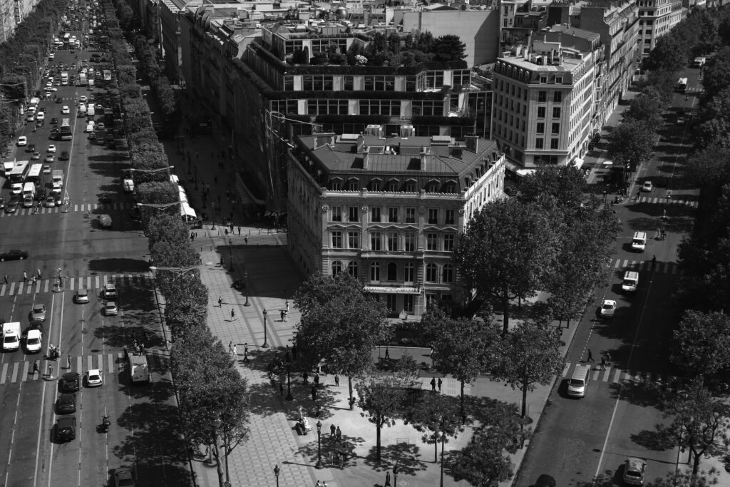
The Hausmann urban development projects and their typical characteristic facades are still a dominant element of the cityscapes of Paris
Photo: Balázs Almási, 2006
The Industrial Revolution of the 18th century led to a significant increase in the population of urban settlements across Europe. As a result, residents began utilizing plots of land outside the fortified medieval cities to accommodate the growing population. Military innovations of the 19th century and the change in the position of traditional defences led to the rebirth of the areas between the historic city centre and the outer districts, as these former defensive structures were no longer necessary.12 The development pattern of this transitional zone between the old city and the outskirts shows distinct tendencies in each different European capital. Some cities, such as Vienna, were able to use the spatial demand of the former city wall as a potential to develop a greenway around the city, known as the Ring.13 Although the imperial Habsburg capitol was inspired by other European cities’ developments of the time, particularly Paris and Haussmann’s interventions, radical solutions were prevented in Vienna by legal and financial constraints.14 Following an imperial decision in 1857, a competition was launched in 1858 and the development plan of the Ringstraße approved in 1859. As the representative boulevard and its surroundings, created on the site of the city’s former defensive walls, were intended to celebrate the power and glory of the Monarchy, it was one of the most important manifestations of the imperial centre’s grandiose urban planning ambitions. The Ringstraße has left the built legacy of a wide, representative urban open space that successfully integrates large green areas and surrounds the historic city core in a belt-like pattern. In addition to prestigious public buildings such as the Parliament, the City Hall, the Opera House, the University, the Art Museum and School of Applied Arts, the Stock Exchange, and the Burgtheater, elaborate residential buildings, public gardens, and public parks were also built along the former glacis area. Besides its recreational and ecological role, the Ring functions as a genuine urban boulevard, with an alley of four tree lines, which offers a pedestrian promenade, a tramway, a riding path, and shops that serve the daily life of the inhabitants.15
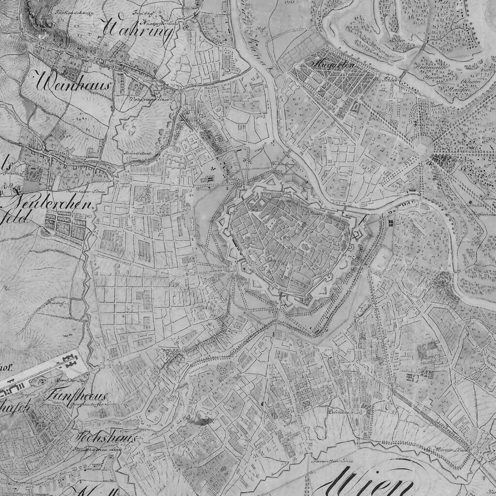
Map of Vienna displaying the glacis around the historic city center, the potential extension of the Ring
Source: Survey of Lower and Upper Austria between 1809–1818, II. kat. f. Alsó és Felső Ausztria.
Archives of the Institute and Museum of Military History, Budapest
Frederick Law Olmsted (1822-1903), with his Emerald Necklace in Boston, USA, represents a completely new approach to urban park design. In 1894, Olmsted created a unique network of parks to meet the city’s recreational needs. His plan linked nine parks with linear parkway and waterway elements, forming a continuous green space system 11 km long, to improve the quality of urban life and bring nature back to the city. The Emerald Necklace is a milestone not only for Boston, but for modern landscape architecture as well, as it set a new standard for designing public park networks and ensuring the continuity of urban green spaces.16 Ebenezer Howard’s (1850–1928) theory of the garden city, published in 1898, served as a new model for urban development that had a major impact on the field of urbanism. Howard’s theory can be interpreted as an anti-urbanist response to the urban problems of the industrial revolution, such as polluted air, epidemics, overcrowding and poor living conditions. The concept of the suburb sought to create a harmonious balance between the city and the countryside, and to address the social and environmental problems of urban life. The main access roads are provided with wide avenues 130 meters wide. Howard’s plans would have created six satellite towns, each capable of accommodating a population of 25–30,000, for a total of around 250,000 people.17 This theoretical system was a response to the unrestrained expansion of London, and Howard proposed the suburb model as an alternative to sustainable, people-centred urban living.18 The theory had a major impact on later urban planning trends and fundamentally changed ideas about the integration of urban and rural areas.
A significant water element of Boston’s Emerald Necklace green infrastructure system
Photo: Krisztina Szabó, 2017
20th Century Tendencies
The green surface system of Vienna was supplemented in 1905 with an Outer Green Ring, also known as Grüngürtel. While the glacis was located along the city center at the time it was developed, the Grüngürtel was established outside the then boundaries of Vienna and was intended to ensure that, as the city grew, green spaces were preserved and recreational areas were made available to the urban population.19 The green ring thus created consisted of public meadows, public fields, and public forests, which surrounded the city in a belt-shaped pattern. The City of Vienna has purchased part of the areas using its budget and has taken legislative measures to ensure that these zones remain intact. The durability and effectiveness of the system are demonstrated by the fact that it is still functioning excellently more than 100 years later and forms the basis of Vienna’s green belt today.20 What makes the Grüngürtel special is that it was the first green belt in the world to be legally and financially protected from building development. Together with other aspects, the continuous green space surrounding the city center is an important factor in why Vienna is recognized among the most liveable cities in the world today. (“City Quality of Life Indices,” 2024)
The 1995 greenbelt and “Green Heart” plan of Berlin
Source: KÜHN, Manfred. 2003. Greenbelt and Green Heart: separating and integrating landscapes in European city regions. Landscape and Urban Planning, 64(1–2), pp. 19–27.
doi: 10.1016/S0169-2046(02)00198-6
Raymond Unwin’s (1863–1940) 1929 design pioneered the design of London’s open spaces. His plan addressed not only the amount of space, but also its distribution and function, a forward-looking approach compared to previous practices. The plan aimed to address the shortcomings of London’s open spaces. Based on the work of the National Playing Fields Association (NPFA), Unwin proposed 2.83 open spaces per 1,000 people (28.3 m2 per person), which would have represented a significant increase. An important innovation was a 3:4 split between private and public space, emphasizing the importance of community space.21 Another important proposal of the plan was the creation of a “green belt” around London. However, this green belt was not intended for agricultural purposes, but mainly for sports fields and recreational areas. The emphasis was therefore on the creation of green spaces for active recreation, easily accessible to the urban population. The plan a placed great accent not only on physical health but also on “character building”, especially for the lower social classes. This social commitment was reflected in the concept of “standard parks”. In these parks, a large part of the area was occupied by sports fields, while a smaller part was planted with ornamental plants. The increasing amount of open space and many elements of the plan, such as the emphasis on the importance of the green belt and community spaces, are still relevant and dominant in London’s urban development today.22
Following the concept of Unwin, Sir Leslie Patrick Abercrombie’s (1879–1957) proposals for open spaces and parks in the City of London in 1943/1944 were based on the recognition that an adequate quantity and quality of open space was essential to maintain and improve the health of the population. The distribution of open spaces in London at the time was very uneven: while Woolwich had 2.43 hectares per 1,000 inhabitants, Shoreditch had just 0.04 hectares. His concept aimed to give urban dwellers easy access from their homes to the open countryside, from gardens through parks and parkways to green wedges and through them to the green belt.23 The solution was a linear greenway, a riverside walkway, a path through farmland, a bridleway, a cycle path or even a car path linking small and large parks and green spaces into a coherent network. The green belt was divided into two parts: the inner ring, about 8 km wide, would prioritise recreation, while the outer ring would favour agriculture. Building activity would have been restricted in both zones.24 Many elements of Abercrombie’s plans have been implemented in recent decades, and they still define London’s cityscape. However, the proposals had some critics, particularly about the green belt, which some have seen as a barrier to the city’s development.
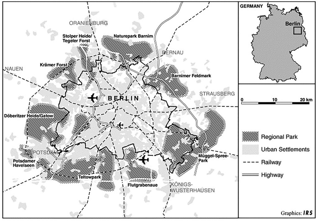
The 2800 km² green ring of 8 regional parks surrounding Berlin was designed in 1995 to separate the city from the countryside. The main aim was to curb urban sprawl, prevent the merging of settlements and preserve the distinctive character of the city and countryside. The idea was that the parks would create a harmonious image of the rural landscape, combining rural-style urban development with nature reserves, recreational facilities and environmentally friendly land use. Its novelty lay in the fact that, instead of becoming a tool to limit urban growth, as many previous green belt concepts had been, Berlin’s regional parks focused on “soft” planning tools, cooperation and “quality development” of the countryside. The emphasis is on preserving the quality of the region and sustainable development, rather than on rigid restrictions. The concept is that regional parks should not be confused with urban parks or nature reserves. These man-made landscapes encompass a wide range of land uses, including urban expansion. However, during the implementation of the concept, conflicts have arisen over the integration of peri-urban actors, many of whom fear that the green belt would reinforce the dominance of the capital.25
The city of Pest surrounded by the medieval city wall
Source: Balázs Almási

The present urban fabric of Budapest with the former city wall and its providential lines and built-up areas
Source: Balázs Almási
Green Ring theories of Budapest
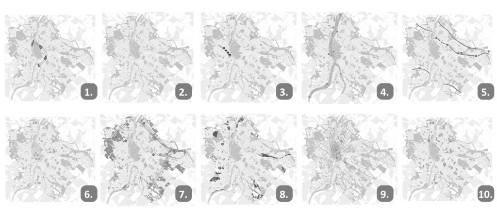
Budapest was officially formed only in 1873, by connecting three cities on the two sides of the Danube: Pest, Buda, and Óbuda. While the settlement on the western river bank, Buda and Óbuda roots back to the time of the Roman Empire, Pest became an important commercial hub during the Middle Ages. The city fabric of the fortified Pest is still preserved, and the former streets still characterize downtown Pest, though the defensive structures disappeared almost completely leaving only a few traces of the former wall. While on the 1785 topographic map of Budapest, only the western section of the wall is missing, no trace of the wall can be seen on the 1830 map of Budapest.26 The demolition of the city wall was executed in several distinct phases, and on the land of the former structure, new buildings were erected.
Though the space utilized for the defense structure between the inner and the outer city fabric was not recognized as a green surface development potential in Budapest, the Embellishment Committee pioneered in announcing a design competition for the first public park in the outskirts of Pest in 1813.27 The execution works of the 136-acre large Városliget began four years later mostly following the concept of the winning landscape architect, Christian Heinrich Nebbien (1778–1841). Though its extension was reduced several times, thus the space structure had to be redeveloped multiple times, it is still among the largest parks in Budapest and has a national significance.28
In 1860, Ferenc Reitter (1813–1874) introduced his vision of the Pest Canal to provide Budapest with a busy artery for transport, traffic, and economic activity, a dominant element of the urban fabric. Reitter’s concept was inspired by a former branch of the Danube that ran through the suggested position of the Canal. Along the Canal alley of trees, green surfaces and elegant facades were imagined. Ultimately, it was not realized, because the city councilors in Pest opted for the Grand Boulevard almost on the same location instead for financial reasons. On the 1873 City development plan, along with the Grand Boulevard, Andrássy Avenue is regulated, both realized at the cost of demolishing and rebuilding the existing urban tissue. The Budapest Grand Boulevard became a modern transport and economic artery of the city, where the first tram, shops, and services were located. The Andrássy Avenue was completed only at the Millennium Celebration of the Hungarian State, in 1896. It became a wide representative urban axis, with a hierarchical multi-phased structure with alleys of trees, linking the city center to the still peripheral Városliget. This link was also strengthened with a visually hidden mean of transportation – the world’s second metro line – running beneath it.
Following the First World War, after 8 years of planning, in 1940 was the first regulation plan of Budapest created, that incorporated the development of green surfaces. On the Buda side, the idea was to connect the suburban forests to the city centre and the Danube directly through 3 green wedges extending from the Buda forests. On the Pest side, the Városliget, the Népliget29 and the Hungarian National Cemetery (called Kerepesi cemetery) were to be connected to the border forest and the green spaces along the banks of the Rákos Creeck, forming a green ring around Pest. Other places would have been connected to this green ring by tree lines and other linear green elements. Unfortunately, the green space development concept of this regulation plan was not realized.
The 1940 green space concept of Budapest
Source: edited by the authors, the base is the 1927 Budapest, G I h 102.
Archives of the Institute and Museum of Military History, Budapest
The green ring concept of Budapest emerged again after the Second World War. In 1952 Zoltán Farkasdy Jr. (1923–1989) imagined his double green ring plan as follows: the inner one would have been smaller green areas and institutional areas along the former city wall of Pest, while the outer one would have continued to be based on the 1940s idea. “My proposal was for a green belt around the city center. It would encompass Roosevelt, Joseph, and Engels squares along the Kiskörút, the park of Deák Square, the Madách houses to be greened, the Dohány Street church, the University, the National Museum park, Kálvin Square and the Fővám Palace, running from the Danube to the Danube. This solution could be a cultural zone embedded in a green park.”30 Despite of the ecological and environmental benefits of Farkasdy’s plan, the last attempt to propose the Budapest Green Ring it was not realized either. The Budapest “green space scheme plan” of 1960 was characterized instead by green islands.
The Green Ring concept of the Art Front Studio connecting the existing green surfaces of the city like a necklace
Source: Art Front Studio
In the following decades until 1989, further regulation plans followed one after the other in Budapest, but in reality, they could not stop the steady expansion of the city. The economic shock following the end of communism in 1990 brought the city’s expansion to a virtual standstill for about a decade, and then it only started to continue again just before the economic revival at the turn of the millennium. With seemingly unstoppable growth and urban development, more and more professionals expressed concern about the shrinking green spaces. The renowned architect Lajos Koszorú made the following statement in 2000: “Budapest’s green space system, despite its extremely favorable landscape conditions, is in a worse position in terms of both structure and size than most of Europe’s world cities of comparable size. The lack of green areas, their poor location, and their continuing degradation have seriously affected the city’s climate and environment. Urban sprawl is accelerating, and the opportunities for recreational green space within the city are becoming increasingly limited.”31 This was a very accurate picture of the situation at the time. The official response to this situation was the Budapest Agglomeration Regulation Plan, which was drawn up in 2005 after lengthy negotiations and compromises. The plan developed under the leadership of Péter Schuchman demarcated the green areas in the Budapest agglomeration, which were protected from urban development.32 As the economic expansion and the resulting construction boom in the agglomeration was very powerful, this plan could only be achieved at the cost of considerable compromises. Facing the increasingly alarming tendency of urbanization and suburbanization, in 2005, the Budapest Centre announced a competition for new architectural signs for Budapest to seek alternative theories and concepts to the official urban regulation plan. The winning concept of the Art Front Architect and Interior Designer Studio,33 evoking former proposals, envisioned a green ring within the city. The designers, Csaba Kovács, Rita Madarasi-Papp, Attila Bakó, Dániel Barcza, suggested a ring in the transitional zone of Budapest, by connecting the areas of the Városliget, Népliget, the National Cemetery, the Kispest Forest, the northern edge of Csepel Island, with the Margaret Island to the Buda green forests. These large green areas would have been interwoven by small forested corridors into a ring.34 Since the ring was driven by not only the environmental but also the recreational aspect, the northern and the southern branches of the ring spanning the Danube suggested the construction of four pedestrian bridges at Margaret Island and Csepel Island.35
A new approach was suggested by landscape architect Balázs Almási in his doctoral dissertation. Instead of seeking possibilities of connection between existing green surfaces, he concentrated on the negative effects of urbanization and suburbanization on the green surfaces of Budapest.
Almási suggested five regional parks surrounding the city. Instead of a pedestrian connection, this plan suggested a green cycle path.36 This concept was continued in a recognized diploma thesis in 2007. The cycling path of a green corridor suggested by Lilla Szabó was running on the flat land Pest from Danube to Danube that was completed to a circle by a riverside section.37
The recent green infrastructure plan of Budapest, the Dezső Radó Infrastructure Development and Maintenance Action Plan aims to protect existing green surface, to prepare the conditions for future increase of green surfaces from the existing 6 m2 per residents to 7 by 2030 and developing a coherent network of the green infrastructure. The main action zones of the plan are the followings:
- The chain of city parks in Pest;
- Cemetery areas;
- The Buda public park axis;
- Open spaces along the Danube;
- Urban small watersheds-valleys;
- Downtown;
- Forests;
- Naturalistic areas;
- Alleys, green lanes and greenways;
- Housing estates.38
Action zones of the Radó Dezső Plan
Source: edited by the author based on the Radó Dezső Plan, Budapest Green Infrastructure
Development and Maintenance Action Plan, 2021.
Available at: https://archiv.budapest.hu/Documents/Rado_Dezso_Terv_2021.pdf
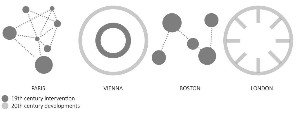
Typology of initial green infrastructure strategies
Author: Orsolya Fekete Bagdiné
Conclusion
Making the world’s cities more liveable has taken various paths. There have been theories that have remained just theories, while other plans were realized. In all cases, the common desire was to make the highly urbanized environment healthier, and greener and to counteract the unstoppable expansion of concrete and paving, in the built environment. The city leadership and the professional associations realized early on that it is not enough to paint green, but also to create a green mass in the city that is close to the ideal in terms of depth, extent, and value. The development of a green network system that is accessible to all urban residents and that mitigates the unfavorable conditions in cities with the services of the ecosystem is expected.
To be sure, the first comprehensive conceptualization of the need and benefits of integrating green spaces in the urban environment, the theory of Loudon was never implemented in London. However, it has formed the basis for many subsequent urban planning projects and paved the way for modern urban planning, with sustainability and livability at its core. It might have inspired the theory of gardencity and the transformations of 20th-century London. Paris had also became a model for the modernization programs of other European cities.39 Only 3 years later, the regulation of new urban avenues within the existing urban fabric was planned for Budapest: the Grand Boulevard and the Andrássy Avenue. The characteristic classicist facades, the representative alley of trees, and the axial grandiose structures with significant focal points were similar in the case of Paris and Andrássy Avenue, though only the second received the UNESCO World Heritage protection. Unfortunately, there are not many public gardens, parks, or green spaces connected to the Grand Boulevard of Pest as it became an economic and transportation artery compared to the Vienna Ring.
Being surrounded by glacis, Budapest had a similar opportunity to develop the space of the former wall for developing a green ring of recreational and ecological significance within the city as Vienna had. Without an imperial decision the protecting this zone, the wall of Pest was demolished and built in gradually. Thus, we can conclude the act of defining areas within the city where urban development was permitted was an essential tool against the uncontrolled expansion of the city. Though the greenbelt of the Hausmann project, the “zone non
aedificandi” around the city of Paris was built during the 20th
century,40 it inspired later green surface system developments such as the Grüngürtel of Vienna, Unwin concept of London and at the end of the 20th century the regional parks of Berlin, which influenced the regional park concept of Budapest.
There were several attempts to create a green ring in Budapest, which was evidentially increasingly outward-looking in the urban fabric. Promising concepts included the so-called Reitter Canal plan of the 1860s, the green ring of the 1940 Budapest plan, and the double green ring of the post-war Farkasdy plan. Even though by the 1960s official urban policy had already accepted the insular green space system of the Pest side, the last attempt of the Art Front Studio Concept developed for the competition of new architectural signs for Budapest synthetised and set to a contemporary context the previous green belt concept. It was even revised by the government in 2011–2012 since its structure could have been an efficient tool for connecting the potential locations of an envisioned Olympic Games organized in Budapest, but as the chance for the 2024 Budapest Olympic Games,41 the concept of the green belt was not realized either.
The greenways of the Hausmann project and the linear green surface element of the Ring could have led to the first realized theory of green surface connectivity, the Olmsted concept of the Emerald Necklace, and later to the complex network concepts of green surfaces like Abercombie’s plan for London or the Dezső Radó Plan for Budapest aimed to create a coordinated system of parks that would ensure a more even distribution of open space and make it easily accessible to all residents.
From the point of view of the population, on the one hand, it is perhaps the size of the quality green space per capita that provides comparability and measurability between certain large cities, although these numbers are far from ideal in most cities. On the other hand, the distribution and uniformity of the green surfaces can be the authoritative and the goal to be achieved as the Unwin concept and the Dezső Radó plan highlight. If in one part of Budapest, the green area per capita is 4 m2, while in another it is 24.3 m2, it can result in a disproportionately large difference in the quality of life. The attainable minimum can be very different, it is influenced by the city structure, the features surrounding the city, and the management’s intention, as well as the strength of the professional side.
In memory of Péter István Balogh.
Balázs Almási, PhD DLA, Krisztina Szabó, PhD,
† Péter István Balogh, PhD DLA , Orsolya Fekete Bagdiné, PhD
Department of Garden and Open Space Design
MATE Hungarian University of Agriculture and Life Sciences Institute of Landscape Architecture, Urban Planning and Garden Art
Villányi út 29-43
H-1118 Budapest
Hungary
almasi.balazs@uni-mate.hu
szabo.krisztina.dendro@uni-mate.hu
bagdine.fekete.orsolya@uni-mate.hu
Notes
1TURNER, Tom. 2016. Green belts: the history & landscape architecture of a key planning idea. Landscape Architects LAA [online]. Available at: https://www.landscapearchitecture.org.uk/green-belts-the-history-and-landscape-architecture-of-a-vital-planning-idea/ (Accessed: 8 July 2024).
2GÓMEZ-BAGGETHUN, Erik and BARTON, David N. 2013. Classifying and valuing ecosystem services for urban planning. Ecological Economics, 86, pp. 235–245. doi: 10.1016/j.ecolecon.2012.08.019
3TZOULAS, Konstantinus et al. 2007. Promoting ecosystem and human health in urban areas using Green Infrastructure: A literature review. Landscape and Urban Planning, 81, pp. 167–178. doi: 10.1016/j.landurbplan.2007.02.001
4 BOZÓ, László. 2024. Climate change: Global and regional challanges. 4D, 72, pp. 58–63. doi: 10.36249/4d.72.5846
5 HAALAND, Christine and VAN DEN BOSCH, Cecil Konijnendijk. 2015. Challenges and strategies for urban green-space planning in cities undergoing densification: A review. Urban Forestry & Urban Greening, 14(4), pp. 760–771. doi: 10.1016/j.ufug.2015.07.009
6 KAPLAN, Rachel and KAPLAN, Stephen. 1989. The experience of nature: a psychological perspective. Cambridge: Cambridge University Press.
7 BOUCHE, Patrice. 2017. Transport planning as suggested in John Claudius Loudon’s 1829 plan for London. Planning Perspectives, 32(2), pp. 271–280. doi: 10.1080/02665433.2017.1289852
8 Turner, T., 2016.
9 RIDEOUT, Amy. 2016. Beyond the Façade: Haussmannization in Paris as a Transformation of Society. Pursuit – The Journal of Undergraduate Research at the University of Tennessee, 7(1), pp. 177–187 [online]. Available at: https://trace.tennessee.edu/pursuit/vol7/iss1/20/ (Accessed: 2 August 2024).
10 Rideout, A., 2016.
11 SAALMAN, Howard. 1971. Haussmann: Paris Transformed. New York: George Braziller.
12 BENEVOLO, Leonardo. 1980. The History of the City. Cambridge (MA): MIT Press.
13 TAMÁSKA, Máté. 2020. Little Vienna – Little Budapest: Ring Boulevards of Three Midsized Towns in the Habsburg Empire, 1848–1920. In: Thomas, A. et al. (eds.). Yearbook of Transnational History 3. Vancouver: Fairleigh Dickinson University Press, pp. 33–54.
14 MAGYAR Erzsébet. 2008. A Habsburg monarchia közparkjai: magánkertek és városi parkok buda-pest társas életében (~1870–1918). PhD thesis. Faculty of Humanities, Eötvös Loránd University, Budapest.
15 SZENDE, András. 2021. Egy birodalom főutcája: a bécsi Ringstrasse. Archtextura [online]. Available at: https://architextura.hu/egy_birodalom_foutcaja_a_becsi_ringstrasse.html (Accessed: 10 August 2024).
16 O’CONNOR, Thomas H. 1983. Review of Frederick Law Olmsted and the Boston Park System. The New England Quarterly, 56(2), pp. 299–302.
17 FRAMPTON, Kenneth. 1992. Modern Architecture: A Critical History. 3rd edn., rev. and enlarged. London: Thames and Hudson.
18 HOWARD, Ebenezer. 2010. The Town-Country Magnet. In: To-Morrow: A Peaceful Path to Realm Reform. Cambridge Library Collection – British and Irish History, 19th Century. Cambridge: Cambridge University Press. pp. 12–19. doi: 10.1017/CBO9780511706257.002
19 TERADA, Toru et al. 2008. The History and Latest Policies on the Vienna Green Belt. Journal of the Japanese Institute of Landscape Architecture, 71(5), pp. 797–800. doi: 10.5632/jila.71.797
20 BREILING, Meinhard and RULAND, Gisa. 2008. The Vienna green belt: From localised protection to a regional concept. In: Amati, M. (ed.). Urban Green Belts in the Twenty-First Century. London: Routledge, pp. 167–183.
21 MILLER, Mervyn. 1989. The elusive green background: Raymond Unwin and the greater London regional plan. Planning Perspectives, 4(1), pp. 15–44. doi:10.1080/02665438908725671
22 Turner, T., 2016.
23 LEMES DE OLIVEIRA, Fabiano. 2015. Abercrombie’s green-wedge vision for London: the County of London Plan 1943 and the Greater London Plan 1944. Town Planning Review, 86(5), pp. 495–518. doi: 10.3828/tpr.2015.30
24 Turner, T., 2016.
25 KÜHN, Manfred. 2003. Greenbelt and Green Heart: separating and integrating landscapes in European city regions. Landscape and Urban Planning, 64(1–2), pp. 19–27, here pp. 21–23. doi: 10.1016/S0169-2046(02)00198-6
26 EKLER, Dezső and TAMÁSKA, Máté. 2016. Ringstraßen im Vergleich.: Varianten auf eine städtebauliche Idee in Wien, Budapest und Szeged. In: Hárs, E., Kókai, K. and Orosz, M. (eds.). Ringstraßen: Kulturwissenschaftliche Annäherungen an die Stadtarchitektur von Wien, Budapest und Szeged. Vienna: Praesens Verlag, pp. 25–62.
27 JÁMBOR, Imre. 2022. Egy tervpályázat margójára. 4D, 65, pp. 78–87. doi: 10.36249/4d.3391
28 FEKETE, Orsolya et al. 2015. Space structure and open space recreation in time dimensions, Case study of the 200 years old urban park, the Budapest Városliget. In: Urban design and spacial planning 44. Krakow: Teka Komisji Urbanistyki i Architektury Oddziału Polskiej Akademii Nauk w Krakowie, pp. 277–282.
29 Slightly larger park than the Városliget.
30 KOLLÁNYI, László et al. 2024. Forty vears of academic research in landscape architecture. 4D, 73, pp. 52-67. doi: 10.36249/4d.73.6049
31 KOSZORÚ, Lajos. 2000. Térszerkezet-alakítás és városfejlesztés. Budapesti Negyed, 28(2) [online]. Available at: https://epa.oszk.hu/00000/00003/00022/index.htm#koszoru (Accesed:
10 July 2024).
32 WOLTERS KLUWER HUNGARY. 2005. 2005. évi LXIV. törvény a Budapesti Agglomeráció Területrendezési Tervéről [online]. Available at: https://mkogy.jogtar.hu/jogszabaly?docid=a0500064.TV (Accessed: 5 December 2024).
33 ÉPÍTÉSZFÓRUM. 2005. Ötletpályázat Budapest új építészeti jeleire. Építészfórum, December 2005 [online]. Available at: http://epiteszforum.hu/otletpalyazat-budapest-uj-epiteszeti-jeleire (Accessed: 5 December 2024).
34 PAP, Milkós László et. al. 2023. The green spaces of the urban fabric shaped by succession. 4D, 70. pp. 68–79. doi: 10.36249/4d.70.4803
35 BALÁZS, Attila. 2011. Gyűrűvé font zöldterületek. Városépítő [online]. Available at: https://varosepito.blogspot.com/2011/02/gyuruve-font-zoldteruletek-budapesten.html (Accessed 15 August 2024); BATHORYNÉ NAGY, Ildikó Réka et al. 2022. Historic Urban Green Network Development. 4D, 62, pp. 12–27. doi: 10.36249/62.2
36 ALMÁSI, Balázs. 2007. A zöldhálózat tervezés metodikai fejlesztése Budapest peremterületének példáján. PhD thesis. Faculty of Landscape Architecture, Corvinus University of Budapest.
37 SZABÓ, Lilla. 2012. A pesti zöldgyűrű koncepciója.
Master’s thesis. Faculty of
Landscape Architecture,
Corvinus University of Budapest.
38 TATAI, Zsombor et al. 2021. Radó Dezső Terv, Budapest Zöldinfrastruktúra Fejlesztési és Fenntartási Akcióterve [online]. Available at: https://archiv.budapest.hu/Documents/Rado_Dezso_Terv_2021.pdf (Accessed: 5 December 2024).
39 PAPAYANIS, Nicholas. 2006. César Daly, Paris and the emergence of modern urban planning. Planning Perspectives, 21(4) pp. 325–346. doi: 10.1080/02665430600892088
40 JORDAN, David P. 2004. Haussmann and Haussmannisation: The Legacy for Paris. French Historical Studies. 27(1), pp. 87–113. doi:10.1215/00161071-27-1-87
41 ÉPÍTÉSZFÓRUM. 2015. A pesti Zöld Gyűrű árnyékában. Építészfórum, December 2015 [online]. Available at: https://epiteszforum.hu/a-pesti-zold-gyuru-arnyekaban (Accessed: 5 December 2024).
DOI: https://doi.org/10.31577/archandurb.2024.58.3-4.4

This work is licensed under a Creative Commons Attribution 4.0 International License