This article reveals the invisible spatiality of logistics by starting from an ordinary act of consumption: placing an order with a single click. It argues that logistics is not merely a technical system of distribution, but a spatial regime that reorganizes production, storage, and circulation. The site of Kocaeli, east of Istanbul, is examined as a key node of global supply chains and a sacrificial geography, while the historical continuities leading from ancient Nicomedia’s horrea to contemporary warehouses highlight the spatial persistence and transformation of this geography. Using situated and practice-based methods such as walking, filming, and drawing, it makes the spatiality of logistics experientially visible.
Introduction
This article begins with an ordinary act of consumption: placing an online order with a single click. While digital interfaces present this action as instantaneous and frictionless, it depends on extensive networks of infrastructures, labor, and circulation that remain largely invisible to consumers. The products arriving at our doorsteps travel through multiple geographies, transport systems, warehouses, and logistical operations that are rarely perceived as part of everyday consumption. Rather than approaching logistics as a purely technical system of distribution, this study understands it as a spatial regime that organizes space according to the demands of speed, continuity, and profitability while simultaneously reorganizing production, storage, circulation, and waste. Drawing on the findings of political ecology and supply-chain capitalism, this study argues that logistics actively produces uneven spatial relations by positioning some places at the center of global flows while transforming others into sacrificial geographies that absorb the environmental, social, and economic costs of circulation. Focusing on the Kocaeli-Gebze corridor in the outskirts of Istanbul, the article explores how logistical infrastructures persist, transform, and reproduce spatial inequalities across historical and contemporary circulation networks. Through this approach, an ordinary act of consumption becomes an entry point into the planetary circulation systems that shape contemporary urbanization and everyday life.
Methodologically, the study adopts a situated and practice-based approach that combines tracing, walking, essay filmmaking, writing, and drawing to engage with the scales, histories, and entanglements of logistical infrastructures from within. Within a feminist research framework, methods are not neutral tools but world-making practices; the researcher’s positionality, modes of representation, and forms of knowledge are continuously questioned. Donna Haraway, questioning scientific objectivity, argues that knowledge is always produced from a specific place, body, and network of relationships. Situatedness compels us to take responsibility for the things we learn to see.1 In this context, the research presented here determines its own perspective rather than looking down from above; it places the researcher within the research itself.
The Ordinary Act of Consumption
“An ordinary day …
I’m walking; I’m seeing billboards … I’m checking my social media account; I am clicking on the links
…A subtle wave of excitement begins to rise…
… with a single tap, I placed an order.
And … Three days later, my new product is at my door. So where did it come from? What kind of journey did it take?
Which hands touched it, and what infrastructure was involved?
I have no idea!”

An ordinary day involves countless external encounters related to consumption. In particular, online shopping has transformed consumption through the behavior of impulse buying. The distance between the screen and desire has been virtually eliminated; the time between desire and order has been reduced to seconds. Consumption has now become an act freed from any delay in time or spatial distance. Under late capitalism, consumption generates a cyclical dynamic of pleasure and guilt: desire is satisfied only to be reproduced.2 In this way, consumption functions as a satisfaction mechanism that keeps the subject within the system. At some point, we know these consumption pleasures are superficial, yet they are so easily accessible and satisfying that we still choose them.
When we open the drawers of our desks, we see a bunch of small objects bought from discount stores and websites… they ended up there somehow. Why do we buy them? Because they are cheap, accessible and for a brief moment, seem necessary, fun, or might come in handy someday. But if we stay with this moment a little longer, these questions arise: Where do the products we purchase with a single click come from? Through which geographies do they travel? And through which infrastructures are they directed? We are largely unaware of the physical journey of the products that reach us; therefore, today’s geography seems covered with wormholes where distance has become meaningless and time has been compressed. Logistics is often perceived as a kind of magic, seemingly capable of placing anything anywhere at any time.3
Contrary to the apparent immateriality of digital consumption, the journey of logistics is extremely real, extremely physical, and deeply spatial. Most of the world’s cargo is still transported by sea. Products are not beamed along fiber-optic cables, nor conjured into existence by some digital sorcery; rather, they are dragged across the planet inside steel mega-ships.4 These circulation networks connect distant sites of extraction, production, storage, and consumption, binding cities into wider geographies of exchange.
Urbanization is a process that transcends traditional boundaries and encompasses a global network of interconnected spaces.5 Timothy Morton6 describes a megacity as “a place within other places” and, drawing on the TARDIS in Doctor Who, suggests that it is “bigger on the inside than it is on the outside”. In this sense, places contain multitudes: they are constituted through relations that extend beyond their visible boundaries. Seen from this perspective, cities can be understood as fields of entangled and interconnecting relations, forming a space of flows7 through which goods, capital, and information circulate across dispersed locations. The products we purchase move through these networks, linking everyday acts of consumption to infrastructures and geographies operating at a planetary scale. Thus, an ordinary purchase on an ordinary day becomes an entry point into a complex, material, and multi-layered process.
Logistics as a Spatial Regime
Logistics presents itself as a regime of speed, solutions, satisfaction; as a technocratic management science of circulation. This framing creates the illusion that logistics is merely a technical system responsible for distributing goods across global space after production. Yet logistics is far more than a mechanism of transportation and delivery. Deborah Cowen8 emphasizes that although the expansion of capitalist markets is often attributed to neoliberalism, “it is logistics that have put the cold calculation of cost at the center of the production of space”. The transformation that Cowen9 refers to as the logistics revolution reconfigured logistics from an activity limited to transportation into a systemic science that determines the location of factories and warehouses and encompasses the entire spatial organization of the firm. Thus, logistics has become a vital component of the production system. On this basis, this article understands that logistics is a foundational spatial regime that simultaneously organizes production, storage, distribution, and even waste; systematically sacrificing specific geographies to ensure the speed, continuity, and profitability of global flows.
Anna Tsing10 uses the term supply chain capitalism to describe the economic formation underpinning contemporary logistics. Supply chains establish a planetary-scale production and circulation system by linking legally autonomous businesses through commodity flows. As large retail chains pressure suppliers to provide ever cheaper products, the exploitation of labor and the environment becomes increasingly embedded within the system. Labor, nature, and capital are mobilized in fragmented forms: labor is shifted to low-cost regions; raw materials are extracted on a global scale; and production processes are dispersed across multiple sites.11 Production is thereby disciplined according to the principles of cost, speed, and flexibility. The ecosystem is transformed into a resource and source of productive energy, while the human body and time are transformed into labor.12 By expanding the reach of networked relations, ecological exploitation, and capital circulation, logistics reproduces and intensifies uneven socioecological conditions.13
These consequences are not accidental externalities of circulation but are systematically distributed across space through unequal allocations of environmental burdens and economic benefits. Therefore, the system inevitably generates hierarchy and exclusion.14 As political ecologists have argued, questions of environmental access and control are inseparable from relations of power. “It is this nexus of power and the social actors carrying it that ultimately decide who will have access to or control over and who will be excluded from access to or control over resources or other components of the environment.”15 This raises a central political-ecological question: who benefits from global supply chains, and which regions bear their social and ecological costs?
It is through this unequal distribution of environmental burdens and economic benefits that logistics produces sacrificial geographies. Certain regions and communities are systematically sacrificed to sustain the speed, continuity, and profitability of global supply chains. These regions are sites where spatial occupation, exploitation, pollution, precarious labor, and ecological destruction are concentrated. Logistics centers, free trade zones, port expansion areas, mining basins, and waste disposal sites: these sacrificial locations are the spatial projections of this regime.
Down the Rabbit Hole: Topography of the Gargantuan Warehouses
This research began with a deeply personal act: tracking my packages on my Amazon order page. Over time, I noticed a pattern: nearly all of my orders were held in warehouses in Kocaeli before reaching me. It is a city near Istanbul, and known for its dense industrial landscape, air pollution, and logistical infrastructures such as warehouses, ports, and highways. This region is one of the key nodes of supply chain capitalism in Türkiye. The area around Kocaeli-Dilovası, in particular, can be understood as a sacrificial geography16 that bears many of the social and ecological costs of global circulation networks. In this sense, Kocaeli emerged as a concrete spatial manifestation of the processes discussed in the previous section. Following my packages became a way of tracing the material geography of logistics.
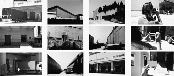
In 2022, I made my first visit to the site. In a way, this was my own journey down the rabbit hole, echoing Alice’s act in Lewis Carroll’s story. What I encountered was overwhelming: industrial zones stretching endlessly across the landscape, steel structures, container yards, warehouses, and highways cutting through the terrain. It felt like a territory entirely reorganized for circulation. At the same time, these spaces had a peculiar and unique sense of attraction. The monumental scale of warehouses, reflections on metallic surfaces, and massive transportation infrastructures created a mesmerizing atmosphere that was difficult to describe.
In an attempt to capture this atmosphere, I experimented with various visual techniques, including analog and Polaroid photography. The limitations of photography were therefore not simply aesthetic but methodological. The spatiality of logistics is produced through movement, repetition, rhythm, sound, and constantly shifting scales of perception that cannot be fully captured in a static image. I therefore turned to the essay film as a medium capable of conveying both the material reality of logistics and my embodied experience of encountering it.17 Through this approach, fieldwork, reflection, and essay film making became inseparable components of the research process.
Situated between documentary and experimental film,18 the essay film is characterized by subjectivity and reflexivity.19 Drawing on Adorno’s20 description of the essay as a form that “gently resists the ideals of absolute certainty, and on Bihter Almaç’s21 understanding of essay film as a practice that “embraces subjective, amateur-ish, irrational, sublime, and playful endeavors through its capacity to create productive short circuits”. Hence, this study adopts essay filmmaking as both a method of inquiry and a mode of expression. The researcher is no longer an invisible figure behind the curtain, instead now becoming an active participant in the production of knowledge.22 The essay filming process shaped the research itself, to questions of scale, atmosphere, rhythm, and perception that became central to the study. Essay filmmaking therefore became a way of thinking through logistical space as much as a way of representing it.
While filming, I found myself writing short notes about the spaces I was moving through. Over time, these fragments formed the narrative framework of the film:
“I decided to follow the receipt [rabbit], tracing my packages.
I find myself in a dystopian universe… Enormous buildings loom before me…
Warehouse doors, gaping like hungry mouths, ready to swallow me whole…
The sound of machines… security cameras watching… I feel like an intruder.
Then the sound of water and the chirping of birds create a momentary escape for me.
The roar of truck engines pulls me back…
As I move forward, I encounter a massive bridge…
I feel like Alice; moving through these spaces means constantly losing my sense of scale, direction, and reality.
The trucks, once imposing, now seem like tiny toys, dwarfed by the enormity of the bridge…
I find myself mesmerized as I watch them.”
I construct this film not as a conventional narrative, but as a practice of urban tracing. With the rise of online shopping, I turn my attention to the gargantuan warehouses proliferating along the urban periphery. In the film, as we move through the concrete topography of warehouse districts, traces of human presence are almost entirely absent; only a single security guard appears. The persistent sound of trucks dominates the landscape, occasionally interrupted by birdsong or the flow of water before the roar of engines re-asserts itself. Highways and bridges emerge as monumental structures that extend the continuity of logistics into space, producing a constant disorientation of scale.
This experience of fragmented perception also shaped the visual structure of the film. The inability to grasp these gargantuan environments in a single glance led me to adopt a fragmented visual language inspired by David Hockney’s photocollages, particularly Sunday Morning, Mayflower Hotel, N.Y.23 Space is therefore not presented through a singular image but constructed through the assembly of fragments and multiple viewpoints.
The essay film functions in this research as a mode of inquiry through which the researcher experiences, questions, and reconstructs their own position within logistical space. In this process, the researcher becomes an inherent part of the research itself. Essay filmmaking therefore serves not merely as a means of representation but as a mode of thinking, enabling the researcher to explore and reflect on their own position.
Historical Continuities of Circulation:From Horrea to Gargantuan Logistical Warehouses
After completing the film and continuing the research, I encountered the Tabula Peutingeriana, a medieval copy of a Roman map depicting the Empire’s transportation and trade routes. According to the map, Nicomedia (present-day Kocaeli) was part of an ancient trade route leading to Constantinople. In antiquity, Nicomedia functioned as a logistical interface supplying Constantinople with grain and other vital goods.24 In addition to grain, construction materials such as marble25 and timber flowed through this corridor, linking distant extraction sites to the imperial capital.26 These flows constituted a regime of circulation essential to the stability of the empire.27
While examining the map, I noticed a symbol positioned in the area corresponding to Kocaeli-Gebze (ancient Nicomedia–Libyssa), where large logistics warehouses are located today.28 Consulting the map legend, I discovered that the symbol represented horrea (Roman grain warehouses), which were built in numerous Roman cities along major trade routes to serve as nodes for storage and distribution.29 Among them, Nicomedia functioned as a major logistical node within the Empire’s network of storage and distribution, connecting routes from Alexandria and Phoenicia to the Black Sea ports of Trebizond and Sinope.30 Situated at the intersection of maritime and overland trade routes, including the Diagonal Road corridor, it served as a major artery of imperial circulation.31
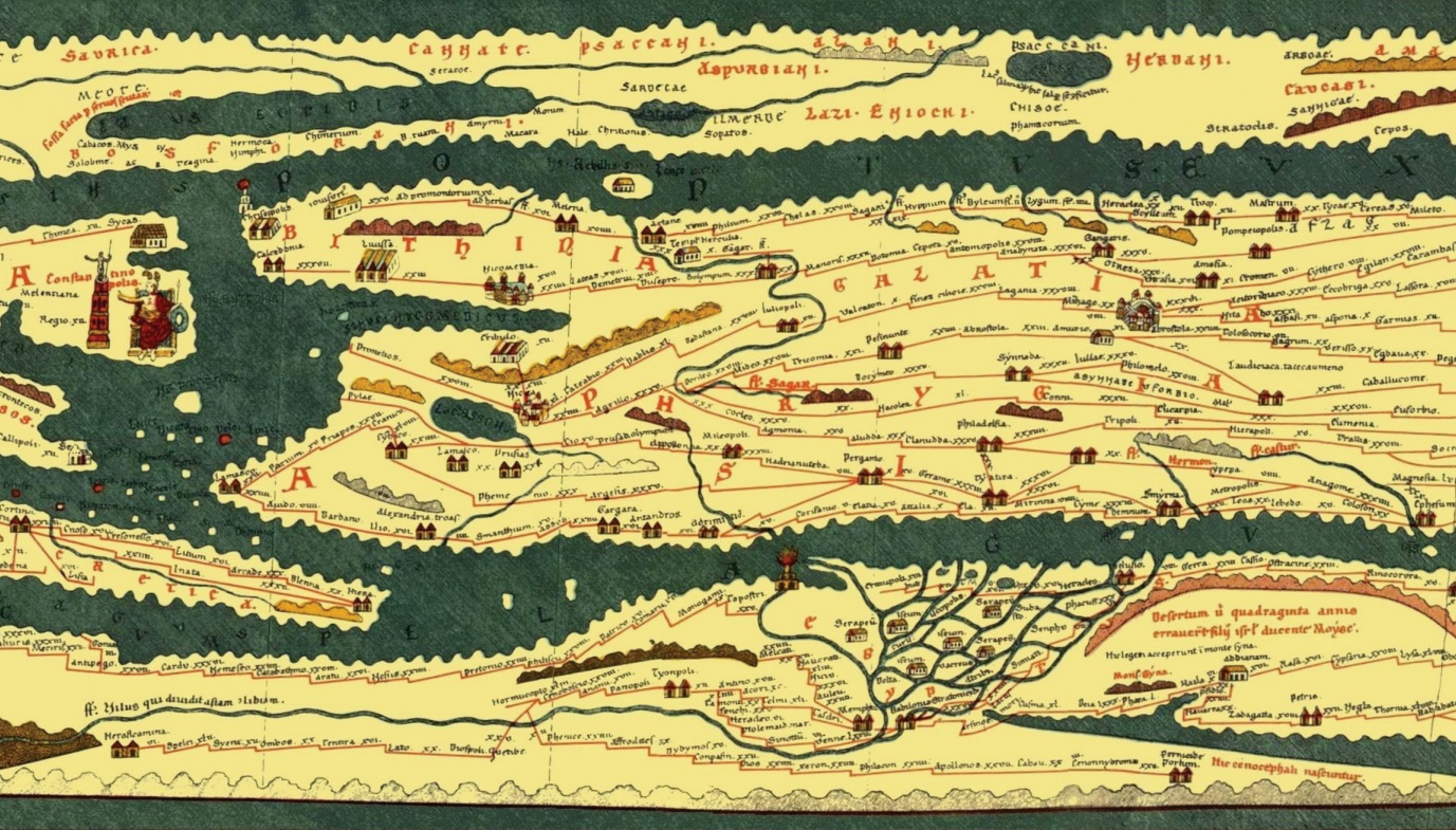
The coincidence was remarkable, suggesting that the logistical significance of the Kocaeli–Gebze corridor forms part of a much longer geography of circulation. Nearly two thousand years ago, the same geography was marked by a symbol of storage and circulation; today, it is defined by immense logistics facilities, bonded warehouses, and distribution centers. The persistence of this logistical geography raises an important question: if the corridor has remained significant for centuries, what distinguishes contemporary logistics from its historical predecessors?
Logistical networks themselves are not new; what is new is the scale, speed, and organizational logic through which circulation is managed. As Tsing32 points out, today’s supply chains do not only organize circulation; they also generate new pressures and frontiers for expansion. What is new is the way network relations continue to expand through ecological conquest and the widening of capital circulation networks, extending and deepening uneven socioecological conditions.33
In ancient cities, horrea played a central role in the organization of urban life by preserving and managing surplus production. As Lewis Mumford34 argues, the ability to preserve the food surplus that emerged with the agricultural revolution was a significant threshold in the city’s origins and continuity. Storage practices, such as setting aside seeds for the following year, also constitute one of the earliest forms of capital accumulation; those who control surplus become decisive over social power. The control of surplus enabled the concentration of resources, the accumulation of wealth, and the consolidation of social power. In this sense, the warehouse was from the very beginning both an economic and a political tool through which resources, social power, and inequalities could be organized and maintained.
Contemporary warehouses inherit this historical function while dramatically expanding its reach and intensity through the logistics revolution.35 Operating at unprecedented scales and speeds, they coordinate the circulation of goods, information, labor, and capital across vast geographical distances. Large-scale, single-story hangars, miles of shelving systems, automated sorting belts, and algorithmic labor management are material expressions of this intensification. The contemporary warehouse has become a point of intensification where flows are continuously synchronized, time is compressed, orders are algorithmically directed and labor is measured in seconds. In this sense, the “just in time” regime is the spatial expression of capital’s control over time.
The Kocaeli–Gebze corridor functions as a laboratory where historical continuity and structural transformation can be observed simultaneously. Once a threshold space for ancient imperial logistics, it has today become a critical node within the speed regime of contemporary circulation. Historical routes linking Nicomedia to Constantinople largely overlap with the transportation infrastructures that structure logistics in the region today, reinforcing Kocaeli’s long-standing role as a source and transfer zone for Istanbul. Precisely for this reason, Kocaeli should be understood not simply as a logistics center but as a sacrificial geography with a long historical continuity, continuing to absorb the social and ecological costs of circulation.
Drawing as Spatial Anatomy: From Nicomedia to Kocaeli
While the essay film documents the speed and temporal regime of logistical flow, drawing extends this research by bringing together the historical layers of the same geography on a paper surface. The central research question was how to approach a vast and historically entangled geography composed of multiple temporalities that cannot be grasped simultaneously through a single image. As Adrianne Joergensen suggests in her discussion of the very large figure, drawing becomes necessary precisely when the object exceeds a single viewpoint and resists total visual capture.36 Contemporary logistics landscapes operate at precisely this scale; their vast warehouses, transportation infrastructures, and distribution networks cannot be fully grasped through a single perspective. Within the Kocaeli–Gebze corridor, ancient storage infrastructures, imperial circulation routes, industrial development, and contemporary logistics networks overlap and coexist within the same territory. Drawing therefore became a way of engaging with this vast, layered, and historically entangled geography.
Drawing functions here as a situated spatial research method through which historical continuities, topographic structures, and logistical infrastructures are explored and interpreted. As Anna Bagnoli37 emphasizes, drawing offers a unique way of creating knowledge. Similarly, Victor Margolin’s38 notion of tool-based and intuition-driven research, in which the aim is not to produce definitive answers but to explore the conditions through which questions emerge and the researcher’s position within them. Drawing also introduced an embodied dimension to the research. Working on a light table, the movement of my fingertips across the cartographic surface transformed the region’s morphology into a tactile experience.

The persistence of storage activities within the same geography across centuries raised a further question: what enables such continuity despite successive political, economic, and technological transformations? The long history of storage practices in this very location led me to look for the constants of this region. What has witnessed all these destructions, speed regimes, and transformations? The answer was the topography: mountains and water systems. These geographical formations became the starting point for my drawing method.
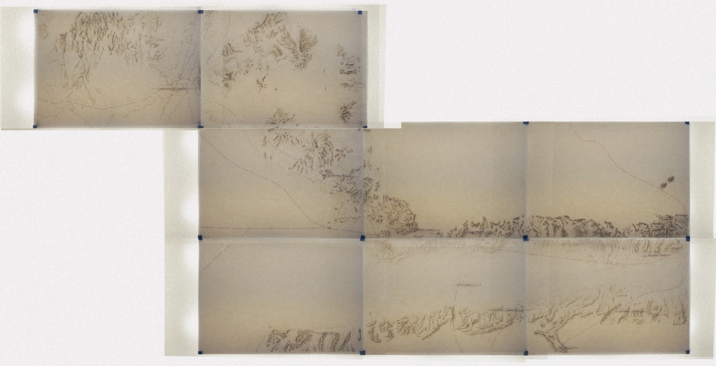
From this perspective, I developed a series of topographic drawings that explore the relationship between geographical continuity and historical transformation. I overlaid the modern elevation maps with the 1879 Admiralty Chart No. 497, Gulf of Ismid39 and employed hillshading techniques while reinterpreting the hachure methods commonly used in nineteenth-century cartography.40 By treating mountain ridges as sectional cuts rather than mere contours, I developed a representational mode situated between plan and section. This use of density and void allows for a three-dimensional reading of the terrain, revealing topography as an active spatial structure.
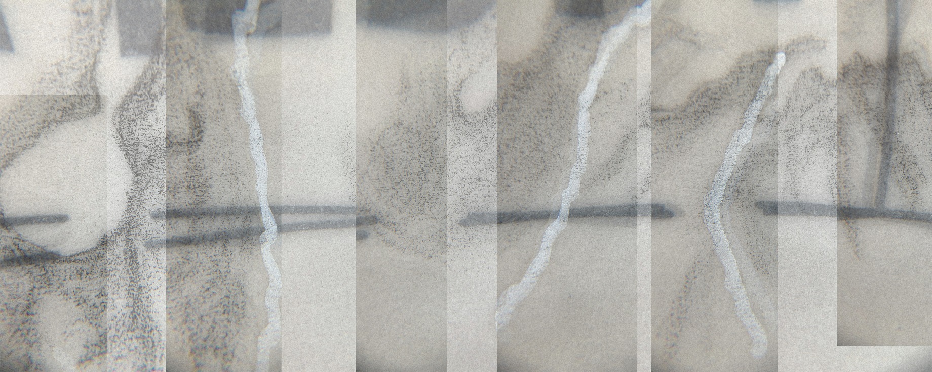
Building upon this topographic base, I introduced historical-physical depth through a layered drawing system inspired by nineteenth-century anatomical flap books. Successive layers depict early settlements, Nicomedia, its walls, ports and horrea, industrial infrastructures, and contemporary logistics warehouses. Through unfolding surfaces, Kocaeli can be physically opened toward Nicomedia and folded back again, transforming the region into a form of spatial anatomy.
In this way, the region of Kocaeli transforms into a temporal anatomy: a structure that is not simply viewed but touched, not static but unfolding.41 On this drawing medium, topography ceases to be a neutral surface and instead becomes an anatomical structure that bears the traces of capital circulation, making visible long-term continuities in the spatial organization of circulation. Through its layered structure, the drawing brings ancient horrea, trade routes, industrial infrastructures, and contemporary logistics warehouses onto the same surface, revealing how successive regimes of circulation have repeatedly reorganized the same geography while transforming relations between storage, labor, ecology, and time.
Conclusion
In this study, I explored the invisible spatiality of global logistics through an ordinary act of consumption: placing an online order with a single click. Tracing this simple act led to a multi-layered infrastructure system extending from ports and highways to warehouses. The study understands logistics as a spatial regime that organizes production, storage, circulation, and waste while producing uneven socioecological relations. Adopting a situated and practice-based approach, the research engaged logistical space through walking, filming, writing, and drawing. Through these practices, the infrastructures of logistics gradually became a bodily and spatial experience.
Essay filmmaking enabled me a mode of inquiry through which logistical region could be experienced, questioned, and understood. The atmosphere of warehouse districts, the continuous movement of trucks, the rhythm of circulation, the shifting perception of scale, and the researcher’s own embodied experience of navigating these environments emerged through the filmmaking process itself. The essay film created knowledge by enabling the researcher to engage directly with logistical space and reflect on their own position within it.
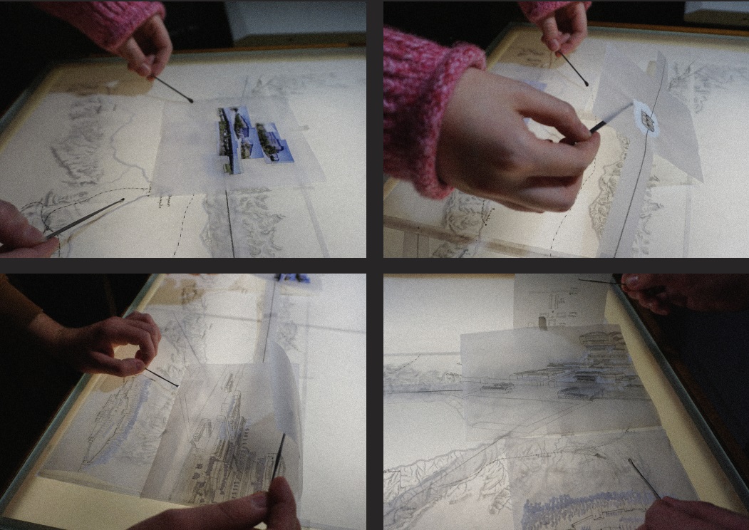
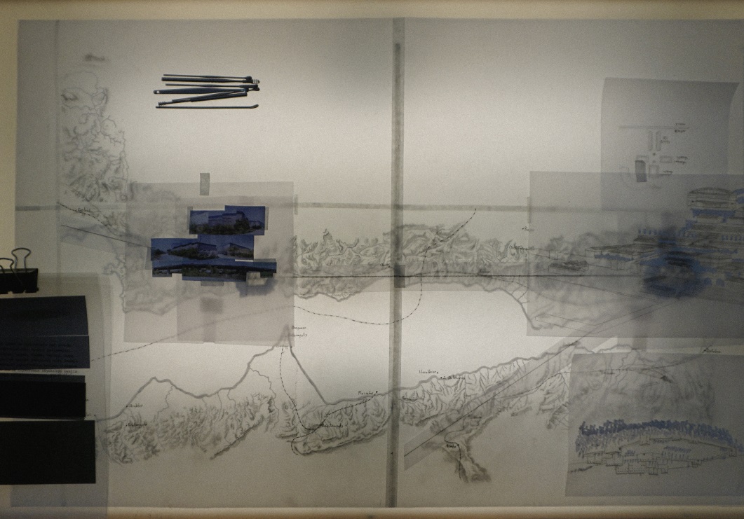
Historical research demonstrated that this spatial organization is shaped through a deep continuity: Kocaeli, known as Nicomedia in antiquity, was used for storage and distribution in Roman times; today, these functions persist through logistics warehouses operating at a global scale. Through processes of drawing, tracing, and layering materials from different historical periods, ancient trade routes, horrea, industrial infrastructures, and contemporary logistics facilities were brought together on the same drawing surface. In this sense, the drawing from Nicomedia to Kocaeli presented a spatial anatomy that carried the ruptures between survival based storage practices and the speed-oriented logistical dominance of the present.
Following a package from doorstep to warehouse revealed a geography operating at a planetary scale. Warehouses, infrastructures, labor networks, and transportation systems emerged as material expressions of a circulation regime embedded within everyday life. Across the Kocaeli–Gebze corridor, contemporary supply chains intersect with much older geographies of storage and exchange, where traces of ancient horrea persist within today’s logistical landscapes. The ordinary package thus becomes a material trace of historical continuities, planetary circulation, and the uneven geographies through which global flows are sustained.
The Aesthetics of Logistics, 2022–2023, copyright of the
author. Photographs from fieldwork conducted in the
Kocaeli–Gebze logistics corridor, showing logistics
warehouses, transportation infrastructures, metallic surfaces,
and industrial landscapes that informed the visual and
atmospheric approach of the essay film.
Source: author’s archive
The essay film Topography of the Gargantuan Warehouses was created as part of the course Architectural Essay Film Practices: Research & Representation offered in the Architectural Design Graduate Program at Istanbul Technical University, under the supervision of Assoc. Prof. Dr. Bihter Almaç.
I would like to thank Rümeysa Akar for her companionship during the filming process. I am also grateful to İpek Avanoğlu for her valuable discussions on drawing and methodology.
Additionally, I am grateful to my students Beyza Karadeniz, Busenur Bulduk, and Tarık Kurt for participating in the sessions of unfolding and engaging with the layered anatomical drawing.
Begüm ESER
orcid: 0000-0001-7373-1929
Department of Architecture Istanbul Technical University Taşkışla Campus,
Istanbul Türkiye
begumeserr@gmail.com, eserb18@itu.edu.tr
HARAWAY, Donna. 1988. Situated Knowledges: The Science Question in Feminism and the Privilege of Partial Perspective. Feminist Studies, 14(3), p. 575. doi: 10.2307/3178066
MARCUSE, Herbert and KELLNER, Douglas. 2007. One-Dimensional Man: Studies in the Ideology of Advanced Industrial Society. London: Routledge.
LYSTER, Clare. 2012. The Logistical Figure. Cabinet Magazine, (47) [online]. Available at: https://www.cabinetmagazine.org/issues/47/lyster.php (Accessed: 5 April 2026)
YOUNG, Liam and DAVIES, Kate (dirs.). 2016. Unknown Fields: Tales from the Dark Side of the City. Available at: https://www.youtube.com/watch?v=cgH-v5CAID0 (Accessed 3 April 2026).
BRENNER, Neil. 2013. Theses on Urbanization. Public Culture, 25(1), pp. 85–114. doi: 10.1215/08992363-1890477
MORTON, Timothy. 2018. Dark Ecology: For a Logic of Future Coexistence. New York: Columbia University
Press, p. 12.
CASTELLS, Manuel. 2000. The Rise of the Network Society. Malden, MA: Blackwell.
COWEN, Deborah. 2010. A Geography of Logistics: Market Authority and the Security of Supply Chains. Annals of the Association of American Geographers, 100(3), p. 600. doi: 10.1080/00045601003794908
COWEN, Deborah. 2014. The Deadly Life of Logistics: Mapping Violence in Global Trade. Minneapolis: University of Minnesota Press.
TSING, Anna. 2009. Supply Chains and the Human Condition. Rethinking Marxism, 21(2), pp. 148–176. doi: 10.1080/08935690902743088
Tsing, A., 2009, p.149.
ODMAN, Aslı. 2025. “His Majesty the Excavation” and the Vestiges of its Lingering Crimes in the Soil. In: Erdem, C. and BILGE, K. (eds.). Grounded: 19th International Architecture Exhibition, Türkiye Pavilion. Istanbul: İKSV, pp. 52–59.
SWYNGEDOUW, Erik. 2004. Scaled Geographies: Nature, Place, and the Politics of Scale. In: Sheppard, E.
and Mcmaster, R. B. (eds.). Scale and Geographic Inquiry. Oxford: Blackwell Publishing, pp. 129–153.
MARTINEZ, Silvia. 2021. Concepts, Conceptos. In: Neilson, B. and Rossiter, N. (eds.). Logistical Worlds: Infrastructure, Software, Labour. No. 3, Valparaíso. London: Low Latencies, Open Humanities Press, p. 107.
SWYNGEDOUW, Erik and HEYNEN, Nikolas C. 2003. Urban Political Ecology, Justice and the Politics of Scale. Antipode, 35(5), pp. 898–918. doi: 10.1111/j.1467-8330.2003.00364.x
LERNER, Steve. 2010. Sacrifice Zones: The Front Lines of Toxic Chemical Exposure in the United States. MIT Press.
ESER, Begüm (dir.). 2023. Topography of the Gargantuan Warehouses by Begüm Eser [online]. Kocaeli, 2023. Available at: https://www.youtube.com/watch?v=hnAa_pNtXmg&t=21s (Accessed: 3 April 2026).
CORRIGAN, Timothy. 2011. Introduction: Of Film and the Essayistic. In: The Essay Film: From Montaigne, After Marker. Oxford: Oxford University Press, pp. 3–10.
RASCAROLI, Laura. 2008. The Essay Film: Problems, Definitions, Textual Commitments. Framework: The Journal of Cinema and Media, 49(2), pp. 24–47.
ADORNO, Theodor W. 1984. The Essay as Form. New German Critique, 32, p. 161. doi: 10.2307/488160
ALMAÇ, Bihter et al. 2025. Three Disentanglements for the Exhausted Geographies. Journal of Architectural Education, 79(1), pp. 268–284. doi: 10.1080/10464883.2025.2463823
Haraway, D., 1988.
HOCKNEY, David. 1983. Sunday Morning, Mayflower Hotel, N.Y. [online]. Available at: https://www.artic.edu/artworks/100864/sunday-morning-mayflower-hotel-n-y (Accessed: 3 April 2026).
TEALL, John L. 1959. The Grain Supply of the Byzantine Empire, 330–1025. Dumbarton Oaks Papers, 13, p. 87.
The aesthetic reflection of this logistical network is evident in the Chora Church. The variety of marble used in the structure’s interior cladding makes visible the geographical reach of imperial logistics: at Chora, Proconnesian white marble, Docimium (Afyon) marble, Tunisia’s Giallo Antico, and Egypt’s red porphyry shape
the interior space. OUSTERHOUT, Robert G. 1987. The Architecture of the Kariye Camii in Istanbul. Washington, DC: Dumbarton Oaks.
MÜLLER-WIENER, Wolfgang. 1994. Die Häfen von Byzantion, Konstantinoupolis, Istanbul. Tübingen: Wasmuth.
MANGO, Cyril A. (ed.). 1995. Constantinople and its Hinterland: Papers from the Twenty-seventh Spring Symposium of Byzantine Studies, Oxford, April 1993. Aldershot: Variorum
PRONTERA, Francesco. 2003. Tabula Peutingeriana: Le antiche vie del mondo. Biblioteca di Geographia Antiqua. Florence: Leo S. Olschki.
KAUFMAN, David B. 1929. Horrea Romana: Roman Storehouses. The Classical Weekly, 23(7), p. 49. doi:
10.2307/4389377
FOSS, Clive. 1996. Survey of Medieval Castles of Anatolia II: Nicomedia. London/Ankara: British Institute of Archaeology at Ankara. p. 3.
Foss, C., 1996.
Tsing, A., 2009, p. 149.
Swyngedouw, E. and Heynen, N., 2003, p. 912.
MUMFORD, Lewis. 1989. The City in History: Its Origins, Its Transformations, and Its Prospects. New York: MJF Books.
Cowen, D., 2014.
JOERGENSEN, Adrianne. 2016. Drawing a Volcanarium, or How to Represent a Very Large Figure. In: Deviated Histories. UCL Press, pp. 96–101.
BAGNOLI, Anna. 2009. Beyond the standard interview: The use of graphic elicitation and arts-based methods.
Qualitative Research, 9(5), pp. 547–570. doi: 10.1177/1468794109343625
MARGOLIN, Victor. 2002. The Politics of the Artificial: Essays on Design and Design Studies. Chicago: University of Chicago Press.
The 1879 Admiralty Chart No. 497, Gulf of Ismid, 1879, which I use, reflects the meticulousness of the map’s production during that period. The survey of the Sea of Marmara conducted with HMS Fawn in 1879–80 continues to be regarded as a masterpiece of its kind.
RITCHIE, George Stephen. 1967. The Admiralty Chart: British Naval Hydrography in the Nineteenth Century. London: Hollis & Carter.
I also explored this drawing method with my students. The layered drawing became a shared platform for discussion through which historical continuities, spatial transformations, and infrastructural relationships could be collectively examined, demonstrating its potential as both a pedagogical tool and an educational
approach.
DOI: https://doi.org/10.31577/archandurb.2026.60.1-2.8

This work is licensed under a Creative Commons Attribution 4.0 International License