The study is focused on the unrealized plans for ring roads in Buda and Miskolc created by Antal Palóczi at the turn of the 19th and 20th centuries. Palóczi’s approach combined functional urbanism with aesthetic principles rooted in the artistic shaping of urban spaces. This dual approach was aligned with contemporary urban planning trends, represented by Josef Stübben’s rational planning and Camillo Sitte’s urban design. The analysed plans exemplify Palóczi’s vision for enhancing traffic flow, public health, city aesthetics and urban greenery. The study combines analysis of the then contemporary thematic press and a review of the original (unpublished) plans with integration analyses.
Introduction
“The purposeful and planned construction of cities, their arrangement and regulation, are necessitated due to the growth of the urban population, the shortage of adequate housing, the deteriorating health conditions, but especially by the radical transformation of commerce and transportation, the rapid proliferation of transportation means, and the enormous development and general upswing of industry.”1 With these words, Antal Palóczi2 (1849–1927), architect and teacher3, presented the standpoint of the five-member review committee4 of the Hungarian Engineers and Architects Association [Magyar Mérnök és Építész Egylet] on the urban regulation plan of Miskolc made in 1894.5 The review, published in the Association’s booklet, briefly summarises the urban planning expectations and tasks to be solved in the period from the second half of the 19th century to the end of the first two decades of the 20th century,6 ones moreover relevant even beyond Miskolc exclusively. The formulated policy can even be seen as Paloczi’s professional creed: in line with the expectations and principles of functional urban planning (Josef Stübben,7 Otto Wagner), the engineering-based regulation of the cities (infrastructure and orthogonal street layout in focus) and, contrastingly but partly complementarily, the artistic-based shaping of urban space by Camillo Sitte.
In his 1889 work Der Städtebau nach seinen Künstlerischen Grundsätze, Camillo Sitte revolutionized the practice of urban planning by advocating for the shaping of urban spaces based on artistic principles. Central to this practice is the organization of road and square networks, where he emphasized visual appeal and “picturesque views,” although he also acknowledged the importance of efficient spatial communication within modern cities.
In his work, he typologized urban forms, advocated for the restoration of continuity with the past, and favoured streets with a layout that adapted to the terrain rather than the modern, straight-line radial roads. This method contrasted markedly with the practice of his counterpart Otto Wagner, who favoured progress and rational (structural and infrastructural) planning, as seen in his urban design competition entries and studies such as Die Großstadt (1911).9
Antal Palóczi considered town planning as an art. As he wrote: “… artistic demands are not opposed to the requirements of expediency and utility. Moreover, the requirements of traffic, construction and public health in the direction of building the city go hand in hand with the demands of beauty. They are so closely related to each other that if the requirements of art were adequately enforced in the organization of the city, we may safely conclude that it would then be in the best position to satisfy the requirements of expediency and other practical demands …”10
According to Josef Stübben, the first step in a successful urban expansion and regulation plan “is the establishment of the building flush-lines on the outer radial streets at a time when building is just beginning. That done, the next step is to establish the real plan of construction: the positions and levels of the ring streets that connect the outer radial lines, the introduction of new radial streets, the arrangement of the diagonal streets so as to distribute the traffic of the outer radial streets in the different districts of the inner city.”11
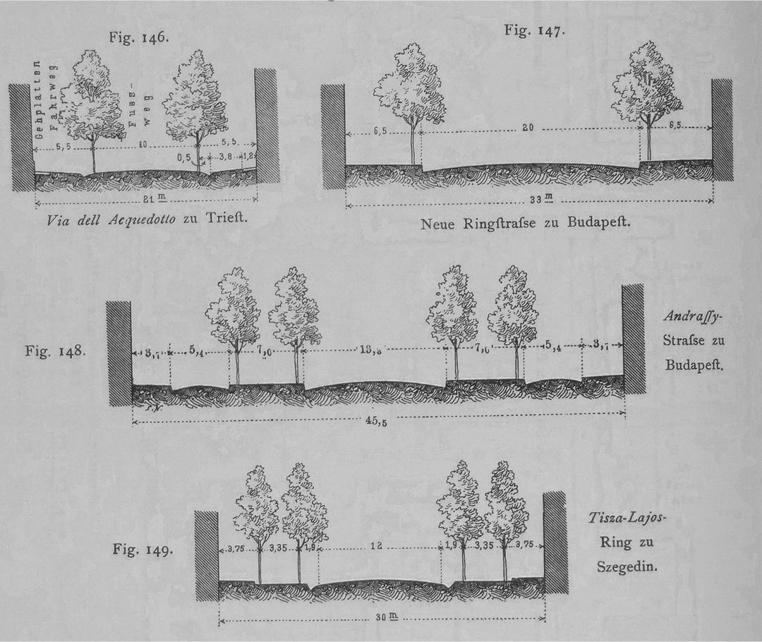
The street network pattern of the cities of the period includes Stübben’s grid pattern (avenues, boulevards, regular grid of streets), applied with disregard to the topography of the area, Camillo Sitte’s streets with lines that adapt to the terrain, or a combination of these. Stübben regarded ring roads equally from an aesthetic and functional point of view: “Broad streets are capable of being very handsomely developed if they are intended principally for pleasure driving, walking and riding and, partly for decoration, partly for the sake of the shade, are planted with trees. Thus are formed those streets that are known under the name of “allées” or “promenades” or if they are situated on former fortified lines, “ramparts, bastions, boulevards” etc. They are also sometimes called “Rings,” girdles, circles, if it is desired to emphasize the fact that they encircle the city. … In Hungary the radial or peripherical direction of the street is clearly expressed in its name; the radial streets are called Sugárút [Hungarian: sugár – ray], for instance, Vásárhelyi Sugárút; the ring streets Körút [Hungarian: kör – circle], for instance, Váczi Körút.”12
Antal Palóczi’s work involved the design of radial and ring roads, as evidenced in the urban plans of Novi Sad and Bratislava13. This study analyzes two previously unpublished and unanalyzed plans, the city of Miskolc and Budapest’s Attila ring roads. These designs exemplify the solutions that Palóczi discussed in his theoretical works.
The Miskolc Town Regulation Plan (1897):
An Unrealised Vision of Boulevards – Squares – Avenues
Miskolc’s regulatory aspirations can be understood as a combination of the urban planning and urban design principles assuming the city to be “regulated according to evolving traffic conditions and public health requirements, as well as aesthetic considerations.”14 Stübben’s principles of functional urban planning, the widening of streets, the regulation of roads according to traffic needs (radial and ring roads), the subdivision of urban blocks with streets,15 promoted communication within the city and improved public health. In contrast, the aesthetic values advocated by Camillo Sitte presented a more complex task of urban planning.
“In order to improve, intensify and develop the traffic in the central part of the city, which has been closed by a ring road, it is necessary to break up the large groups of houses with new road breakthroughs and make space available for traffic.”16
In his other urban planning studies and practice, Antal Palóczi also followed the ideas considered important in Miskolc. “The regulation and arrangement of the city is not a work which once and for all imposes the definite and immutable form into which the city must later grow. No, it cannot be anything but an operation which merely forms the basis for future expansion, and can only be required to meet the needs of the foreseeable future to such an extent that, in the case of later necessary transformations and reconstructions, what has been created can continue to be used and developed. Four urban development factors, it is said, must be taken into account: traffic, urban development (its inherent forms and shapes), public health and, finally, aesthetic requirements. Only a fair compromise between these different demands can lead to a goal.”17 In addition to the four urban development factors, Palóczi also considered a fifth, i.e. industry. A factor which partly determines the previous four and which also has an impact on the city’s economy. It also determinates the green spaces and has impact on “beauty requirements” through the public health issue.
Antal Palóczi, together with the members of the designated committee18, commented on Miskolc’s proposed regulatory plan and prepared their own concept19. In the draft plan, the committee, as Palóczi indicated, incorporated most of the solutions proposed by local engineers Béla Lippay, state railway engineer, and Károly Adler, chief town engineer,20 but in many ways they deviated from the original plan.
The plan from 1897 has previously been considered in the literature as the work of Lajos Lechner, as István Dobrossy, the local historian of Miskolc, wrote, “Today it is impossible to decide how much merit Lechner, Palóczy [Palóczi] or the other experts have in the draft.”21
In 1958, the architect Béla Horváth, after comparing the hand writings and studying the plan, wrote: “The first regulatory plan of the city was drawn up in Budapest in January 1897, and among its signatories we find Lajos Lechner, an engineer, presumably as the designer.”22 On the other hand, writes Dobrossy, Béla Horváth, at a conference entitled Lechner and Szeged in 1997, identified Lechner as the designer. “The identity of the author of the plan became more complicated by an issue of the paper Szabadság.”23 In it, an article entitled “Lucza-széke” [Lucza’s Chair]24 draws attention to the need “to establish the regulatory line for the entire area of the city as soon as possible, from which no deviation is allowed thereafter. It would therefore be desirable to obtain the Adler–Lippay draft and perhaps also the Antal Palóczy [Palóczi] draft.”25 Published during Lechner’s lifetime, the article refers to the design exclusively as Palóczi’s, not mentioning Lechner as an author.
Palóczi also presented an opinion on the plans in Miskolc, after which he published his thoughts in the Mérnök- és Építész Egylet Közlönye [Bulletin of the Hungarian Engineers’ and Architects’ Associations].26 If we look at the plan, we can see that it reflects Palóczi’s design principles rather than the geometric and regular lines of Lechner, which he used for Szeged and Pest. In the light of Lechner’s previous works and Palóczi’s later city plans, it can be stated that the similarities between Palóczi’s plans for Bratislava (1908, 1917), Novi Sad (1910/1911)27 and the city regulation plan for Miskolc28 suggest that Antal Palóczi was one of the main authors of the 1897 plan.29 This contention is also supported by the leading ideas of the opinions published on the plan (Sitte’s principles), which reflect his town planning studies and his lecture on the regulation of Bratislava, published a few years later. The plan in question is a less developed version of the principles later applied in Bratislava and Novi Sad. However, such a conclusion does not mean that Lechner had no role in the drafting of the plan, as the signatures on the original plan confirm. It is likely that the final design and shaping was not the work of Lechner or the other signatories (Ferenc Devecis, Imre Francsek, József Mihályfi), but of Antal Palóczi.
On his planning principles of Bratislava, Palóczi writes as “I would find it a serious mistake … if a templated, indifferent division were established in the area intended for the growth of the city, and the linear rastrum would be attempted and applied with the elimination of all artistic sense.”30 Contributing to these planning directions is Palóczi’s following of principles in response to new needs caused by progressive urban development: “For the expedient handling of urban traffic, but also taking into account other factors in the construction of the city, main roads running in circular and diagonal directions are the most suitable.”31
In the plans for Bratislava and Novi Sad, the alignment and rhythm of the streets in the areas between the ring roads and the radial roads varies from area to area. Palóczi accentuated the aesthetic quality and variability that Camillo Sitte hoped to establish. “The irregularities of the terrain, existing waterways and roads, should not be forcibly eliminated to achieve merely a banal rectangularity, but instead preserved as a welcome excuse for incomplete streets and other irregularities.”32 Similarly, this principle is reflected in the Miskolc plan, as the new streets facing the Calvary and Avas hills were designed to reinforce the existing features of the landscape. An orthogonal street network emerges only where the terrain and the area’s function (industrial) justified it. The right-angled streets, though, enclose blocks that are not completely regular, thus providing the opportunity for wider variations in the combination of the urban structure and the built environment.33 The draft plan made by Palóczi and his peers differed from the original Adler-Lippay plan on the regulation of the downtown. It proposes the creation of a ring road, to be constructed with minimal modification of the original street network, “because the configuration of the city is so fortunate in this respect that more than three-quarters of the ring road around the city is almost complete. The route from Nagymajor Street, along Széchenyi Street, Király Street and the fairgrounds to Szeles Street will form a completely enclosed ring road as long as the relatively short Fazekas (Jókai) Street is widened to the necessary width.”34
Plans were already underway for the construction of the courthouse (Palace of Justice, Ferenc Jablonszky, 1899).35 The committee recommended that the building be erected at the corner of the planned ring road, specifically on the front where Nagymajor and Jókai Streets intersect.”36 The original regulation plan envisioned the building on a plot located between existing houses, as ultimately realized in 1899. Citing newspapers from the end of the 19th century, the scholarly literature attributes the design to István Kiss. Palóczi also suggested that Kiss should be the architect. Dobrossy, however, based on more recent findings, wrote that the architect was “Ferenc Kiss-Jablonszky”37 although no architect by that name exists. The only known architect involved was Ferenc Jablonszky, who had designed other court buildings. The confusion may arise from the fact that Kiss, a Budapest-based architect, was commissioned to supervise the construction.38
The proposed solution would alleviate traffic congestion on Széchenyi Street, establish a sound direction for the expansion of the light-rail network, “expand and extend urban life to a larger area and scope, and ultimately improve the central part of the city.”39 The plan advocates for cutting roads through larger urban blocks to increase traffic flow and enabling the diversion of the Pece creek out of the city. Additionally, it suggests collecting the stream’s sediment in settling ponds outside the city and directing the clean water through a covered channel into the Szinva creek via Nagymajor Street.
The plan also proposed radial routes to supplement the ring road: 1. within the city, running towards the railway station ad in the area along both banks of the Szinva stream, with a third radial road as an extension of Széchenyi Street; 2. radial roads parallel to the transverse axis (Kazinczy and Szemere Streets), which the committee proposed widening to 20 meters.
The Szinva stream was also given a role, as the plan suggested diverting its course away from the built-up areas and routing it through an open channel, accompanied by a wide road, park, or promenade. “This operation, although on a larger scale, would provide the city with advantages that would have a very pleasant effect on both its residents and visitors. Here would be an imposing and beautiful promenade to the inhabitants, the beneficial effects of which would be felt all the more as the city’s population, both young and old, would find their most favourable recreational and walking areas here. The committee therefore would distribute such promenades, children’s playgrounds, and parks proportionally along the regulated Szinva stream and connect them with the surroundings.”40
In 1908, in his work A mai városépítés alapelvei [Principles of Modern Urban Planning], Palóczi also highlighted the importance of accessible green spaces. The creation of playgrounds and sports facilities reflected the leading urban planning ideas of the time, which viewed public health as a primary concern and a central task of urban planning: “6. Public parks and plantings. We consider these to be the lungs of the city, and every city dweller has the right to reach them easily and quickly. Public spaces are made more beautiful and pleasant by greenery; separate parks and promenades, children’s playgrounds, sports facilities, etc. are necessary to protect the physical health of the urban population.”41
From the Attila Road Section of the Buda Ring Road to the Urban Regulation of Tabán – an Unrealised Vision
Development of the Buda side in the unified capitol city placed great importance on the Buda inner ring road, which was connected to the Erzsébet Bridge. The regulation of Attila ring road and its surroundings, and the initiation of land expropriation process, promised the urbanization of the Tabán district. As the Capital City Public Works Council [Fővárosi Közmunkák Tanácsa – FKT] wrote in its 1906 report: “Similarly, the Erzsébet Bridge, built at great expense, will only be able to fully fulfil its purpose if Attila ring road is regulated to meet its main traffic character and its plots are developed in an urban manner.”42
The regulation of the Attila Road section of the Buda ring road, a precursor to the urban development of Tabán, would – if implemented – have meant a complete transformation of the district’s structure. The change of scale in the plan proposals and regulatory concepts can be observed not only at the level of the urban blocks along the proposed road, but also at the level of the adjoining street network.
In the year 1908, when the law regulating Attila ring road came into force (Act XLVIII of 1908), the route was formed by Margit and Krisztina Boulevards, Attila ring road itself, the right-bank approaches of Erzsébet Bridge, and Gellért Embankment. The regulation and construction of this ring were organically linked to the inner boulevards of Pest (Lipót, Váci, Károly, Múzeum, and Vámház). The route, completed into a full circle by Margit Bridge and Franz Joseph Bridge (now Szabadság / Liberty Bridge), served the urban traffic needs with radial roads branching off in various directions. “Only the Eskü Square Bridge43 could serve as the starting point for the ring roads and, more generally, the road network of Buda. This should dominate the city map, and therefore an organic connection with this centre should not be solved by subsequent additions,” wrote Soma Mudrony in 1893.44
Originally, the Buda ring road was planned to continue from Vérmező Road into Attila Street, and to achieve this, the plan was for the street to be widened. However, the FKT’s report of 188545 stated that the Buda ring road took a different direction, and the widening of a section of the road, north of Mikó Street, was abandoned. Until 1899, the inner ring of Buda was gradually regulated and developed section by section at the joint expense of the FKT and the capital city, except for the part of Krisztina Boulevard that extended from Mikó Street to Maros Street.46 In this area of Buda, not only the terrain but also the watercourses made the urban development difficult. The FKT considered it essential that “the line of the Ördögárok brook should be brought under public land everywhere.”47
The 1906 report of the FKT states that as early as the 1880s, an agreement was reached with the capital city to clear and regulate the route of the inner ring road on the right bank through conjoined forces – thus most of the ring was regulated, but the widening of Attila ring to 10 fathoms,48 in accordance with the regulation line, was not completed. In 1906, the regulation of Attila ring road was again put on the agenda: “because the current situation, given the development of the light rail transit into a double track, traffic of carriages and the already heavy carriage and especially freight traffic, is intolerably dangerous from a safety standpoint, especially at points where the narrowness of the road makes the normal flow of traffic impossible.”49
Based on its resolution no. 270662 of December 13, 1906, the city government did not take a position before ascertaining the expropriation costs, but it agreed to the formation of a joint commission to deal with matters related to Attila ring road. They proposed the widening of Szarvas Street by 6 fathoms and the provision of a first-class surface for Árok Street (a section of today’s Krisztina Boulevard) as the final width of the ring was determined to be 10 fathoms, thus raising the question of widening Árok Street from 6 to 10 fathoms.
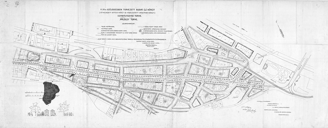
Architect Antal Palóczi and technical councillor of the capital city Ferenc Devecis50 were entrusted with developing a regulatory plan. Continuing the discussions, Palóczi presented a conceptual design in 1907, the key element of which was the widening of the road.51 Both planners’ proposed designs suggested that the new ring road would start from the bridge crossing at Döbrentei Square and follow the line of Árok Street to reach Szt. János Square.52 [Fig. 3]
Palóczi proposed a width of 26 meters for the ring, while Devecis suggested 30 meters. Earlier, Devecis, who did not wish to open a new route but merely to improve the existing one, promised to “study Palóczi’s plan.”53 After considering the proposals, the capital city decided to open a 30-meter-wide road and requested the consent of the FKT. The FKT referred the matter, along with the calculations of the city’s technical department, to the technical committee of the FKT, to decide based on its recommendation.
On May 10, 190754, Palóczi presented his plan to the FKT and the committee of the capital city. He explained that the plan being considered by the authorities, the capital city, and the FKT in 1907 was one that he had already presented to the National Industrial Association [Országos Iparegyesület – OI] in 1892. Additionally, the OI had commissioned a large plaster model of the regulation of the Tabán district.” It was this model that Palóczi referred to in his submission to the city council in 1907.
The Fővárosi Közlöny [Capital City Gazette – hereafter FK] published both Antal Palóczi’s and Ferenc Devecis’s proposals in its 53rd issue of 1907. The background materials for the regulation of Attila ring road were, in turn, published in the 37th issue of the FK on May 7, 1907.55 On May 22, 1907, the general assembly of the capital city returned the regulation matter to the council for revision due to the opinions expressed at the meeting. By this time, Palóczi’s memorandum (dated May 10, 1907) had already been submitted, and Devecis’s plan was also in preparation.
In his memorandum, Palóczi referred to his concept from 1892, which was directly related to the Attila ring: the regulation of Tabán in Buda. Palóczi believed as early as 1892 that the neglected, village-like district of Tabán should be integrated into the metropolitan, progressively developing Budapest, as “1. due to its central location in the capital city, it will be connected directly to the Inner City by the planned bridge at Eskü Square; 2. it forms the foreground, the immediate surroundings, of our monarch’s Hungarian palace.”56 Palóczi revised his 1892 plan to meet new demands and to respond to changes in the urban structure. In the meantime, the Eskü Square Bridge (now Erzsébet Bridge)57 was built, and the Tabán district in Buda was directly connected to the Pest centre via the bridge. Consequently, traffic through Tabán increased, leading to the need to regulate the district and put the issue of the Attila ring on the agenda.
In May 1907, Palóczi gave a lecture at a joint meeting of the OI58 on the urban planning issues of the Buda side: “How the Attila Boulevard should have been built and should still be built?”59
Budapest was still being developed from unconnected individual plans, without a coherent urban development program that would clearly define the directions. Thus, the isolated projects on the Pest side (Eskü Square, Új Épület, Erzsébet radial road, railway station arrangements, bridges) were joined with the ideas for the Buda side. The widening of Attila ring road was already approved by the FKT in 1892, but the capital’s construction committee rejected the proposal. However, the Erzsébet Bridge (then the Eskü Square Bridge) brought renewed urgency to the designation and regulation of the route. According to the 1892 proposal, a 30-meter-wide, impressive route would start from the bridgehead of the Erzsébet Bridge, “with an approach to urban planning that requires not only width dimensioning but also an art of management and planning.”60 This route would led between the Rác Thermal Baths and the Serbian Orthodox church61 following the line of the then Árok Street with a slight curve, and would expand into an imposing square in front of the royal palace. In its 1907 decision, the FKT adopted some regulations to alleviate the lack of a wider radial road, such as the widening of Árok Street. In the official 1907 report of the FKT, a description is given of the widths of the roads representing the inner ring road of Buda, and it is added that “the section of Attila Street between Szt. János Square and Szarvas Square could only be made wider than 10 fathoms by sacrificing the diagonal plots serving Árok Street.”62
However, one unavoidable factor was the impossibility of widening Palota Street without moving backwards the façade line of the church along the route, so the continuation of the widening through the streets called Buda ring was reduced to 10 fathoms. “… The Döbrentei Square and the Gellért embankment, which is considered the final part of the Buda ring, has been set at a width of 12 fathoms.”63
In his submission in the FK regarding the regulation of Attila ring road and its surroundings, Palóczi writes that “[t]he planned new “Boulevard” starts from the Erzsébet bridgehead and, with a slight inclination, generally follows the direction of the current Árok Street all the way to Szt. János Square, where it branches off into two directions that can be considered sufficiently wide for traffic: Krisztina Boulevard and Attila Street.”64
Palóczi’s new proposal considers the provisions adopted and the new buildings along the route that were built between 1892 and 1907: “The new school building at Fehér-Sas Square is not affected either, only its open forecourt will be given a different shape.”65
As minimum width of the road is 26 meters or 14 fathoms (the minimum width of a road with a light railway), according to the urban planning principles of the time, “it is not possible – nor desirable – to lead the main route straight through the valley area, since the aesthetic value of a slightly curved road is much higher than that of a straight road.”66 Not only did Palóczi support the construction of the proposed road with aesthetic and functional arguments but also expropriation data and the cost of implementation – indicating the widening of Attila Street and Árok Street to be a less favourable solution than the creation of a new “boulevard”, moreover one leaving the Ördögárok untouched for its entire course.67
The Pesti Hírlap [Pest Newsletter] published a report in the Fine Arts section about the meeting of the Association of Hungarian Architects [Magyar Építőművészek Szövetsége] held on June 6, 1907, entitled “A főváros művészi kiépítése” [The Artistic Development of the Capital City].68 Antal Palóczi gave a lecture on the regulation of the Attila Ring, presenting a large-scale plan routing a large main road through the Tabán district, emphasizing that implementation of the project and construction of the route would ensure the gradual development of the most deprived part of Buda. It may come as a surprise that the Fine Arts section reports on the presentation of the urban planning task, but Palóczi considered urban planning to be a form of art.
A proposal by Ferenc Devecis written on June 22, 1907,69 was also published in the FK. Devecis did not assume the planning of a new ring road, but instead the regulation of the current Attila Road, which he proposed to widen to 30 meters, as further justified in his submission. Devecis reviewed Palóczi’s plan and rejected it. Interestingly, he gives one of the reasons for the insufficient width, when in the same text he notes that another alternative is a 25-meter-wide ring road, which he would recommend if the capital city council did not accept the 30-meter width. Devecis addressed every detail of Palóczi’s plan, proposed two new plans and prepared a budget for both solutions.
In his proposal dated June 23, 1907, Adolf Heuffel, director of public constructions, stated that the Tabán district on the Buda side was the main distributor for traffic arriving from the Pest inner city at the time the issue was being discussed, so the traffic in that area would not increase to the extent that the planners (Palóczi and Devecis) envisioned. However, the regulation of main roads would be necessary to handle traffic. Regarding the Attila ring road issue, he did not reject Palóczi’s plan, as he writes “first of all, we must consider the plan of architect-teacher Antal Palóczi”70 Heuffel, like Devecis, analysed one of the important aspects of the regulation, the extent of widening the ring road and surrounding streets, and also prepared the budget. In all three budgets, the largest single sum is the cost of expropriations, alongside the costs for sewerage and road construction. Devecis’s budget also includes landscaping.
Counsellor Gyula Kun, on behalf of Department III of the city council, noted regarding the Palóczi and Devecis plans that the drafts go far beyond the planning of the ring road, making it no longer a regulation, but a completely new urban development plan, “so that an existing city ceases to exist and a new city is created in its place.”71
The construction committee’s decision assumed the necessity of creating a new ring road 30 meters wide, and the plans would be returned to the engineering office for re-drafting. The title of the plan prepared by Antal Palóczi in 1907 was “The 30-meter-wide planned new Buda ring road: Relocation of the Attila Ring and Widening of Krisztina Boulevard: regulatory plan”.72 Intriguingly, the plan’s legend reveals the original idea, as the proposed line of the new boulevard is 26 meters wide. According to the title, “this plan was compared, recalculated and reviewed with the plan of Department I of the engineering office in June 1908 by the Budapest city engineering office, Adolf Heuffel, director of public constructions, and Mottl.”73 The plan bears the name of Ferenc Devecis with a date of June 1897 (crossed out), and Palóczi’s signature stating that he revised the plan on November 5, 1908.
In the following year, no agreement was reached regarding the route of the Attila ring road. However, urban planning was extended to the Tabán as well, and several alternative plans were developed by the capital city, the technical committee of the FKT. Some members of the Hungarian Society of Engineers and Architects also participated in these plans, including Antal Palóczi.74
In 1910, according to the report of the FKT, the reallocation of the funds allocated for the regulation of Attila ring (Act XLVIII of 1908) was proposed, to be used instead for redevelopment of the Tabán. In the same year, parallel with the expropriations already underway, the detailed regulatory and development plan of the Tabán began to be developed in the capital’s engineering office. The idea of rebuilding the district arose in 1909 during the discussions on Attila ring road, and the final regulatory and development plan was established in 1911. According to Palóczi, “… in this official plan, there is not only a certain rigidity in the lines, but also that uneven façades are placed opposite each other, and that the square in front of the Rác Bath is immediately followed by the space expansion formed by the obliquely standing façade of the school in the Fehér-Sas Square, the uniform grand effect of the route is fragmented, its monumental beauty is weakened. … the concave setting gives a beautiful effect, any convexity should be avoided at all costs, not only in the façade of the buildings, but also in the level of the street.”75
In his proposed solution,76 which complements the capital’s plan, he eliminates the expansion of space created by the obliquely standing façade of the school in the Fehér-Sas Square, which follows the square in front of the Rác Bath, avoiding any interruption of the concave line of the route. In turn, the shape of Szarvas Square is also changed, leaving it irregular thanks to the wide street that flows into it according to the regulatory plan.
The question of the regulation of the Tabán remained open for decades, and the task was revisited in the 1920s after the First World War. With the implementation of the regulations, it would have been completely rebuilt, which could have been a forerunner of the emerging modern era: “When rebuilding old cities, one must proceed systematically and uniformly. If the old houses cannot be preserved, they must be demolished all at once, either by streets or by blocks, and the thus obtained and regulated area must be rebuilt. This is what the city of Prague did in the last decade when it rebuilt the Jewish quarter, and this is how Budapest will proceed when, at the suggestion of Antal Palóczi, a tabula rasa is created on the site of the Tabán.”77
Proof of the Concept – The (Unrealized) Ring in Miskolc and the Role of Green Spaces
According to Antal Palóczi, a city’s primary road network should consist of three main orientations: circular, radial, and diagonal roads. These roads should form a “clear, organically connected, and well-woven net encompassing the city.”78 “As a city grows, traffic increases, and congestion occurs at certain points, making diagonal roads necessary, which are most effective when planned and constructed in advance. The intersections of circular and radial roads typically serve as starting and ending points for diagonal roads, as well as for public spaces, railway stations, and other traffic-generating institutions. At the intersections of radial, circular, and diagonal roads, nodes are formed where buildings should be set back, creating open spaces. These traffic spaces, represented as road intersections on city plans, are among the most challenging aspects of traffic management.”79
Palóczi’s ideas are most evident in his comprehensive city plans (e.g., Bratislava, Novi Sad, Miskolc), yet even in his more detailed plans for smaller areas (e.g., Tabán in Budapest, Arad) we can observe telling details, such as moving the building blocks backward at road junctions.
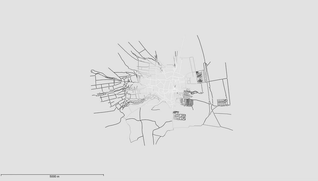
One of the primary development goals of the proposed Miskolc plan was the construction of new roads, including a ring road and a green belt along the Szinva creek. The new urban structure aimed to eliminate narrow alleys and mitigate inequalities within the urban structure. The differences between the original survey plan (1885)80 and the two new proposals (Adler–Lippay 189581 and Palóczi 1897) can be visualized by measuring integration, in this sense defined as “a normalized measure of distance from any space of origin to all others in a system.”82 Here, distance does not refer to metric distance but to a topological one. The level of integration in the greyscale figure is shown by the gradually changing line shades from white (highest) to black (lowest).
The 1885 map of Miskolc, based on the latest survey created by Károly Adler, revealed significant disparities in the city’s connectivity. While the city centre exhibited high levels of integration, indicating a well-connected network of streets, the areas outside the medieval core, particularly those with numerous alleys, had lower levels of integration: disparities largely attributed to the presence of numerous narrow alleys. Historical records, in turn, support the notion that areas with low integration were less developed.
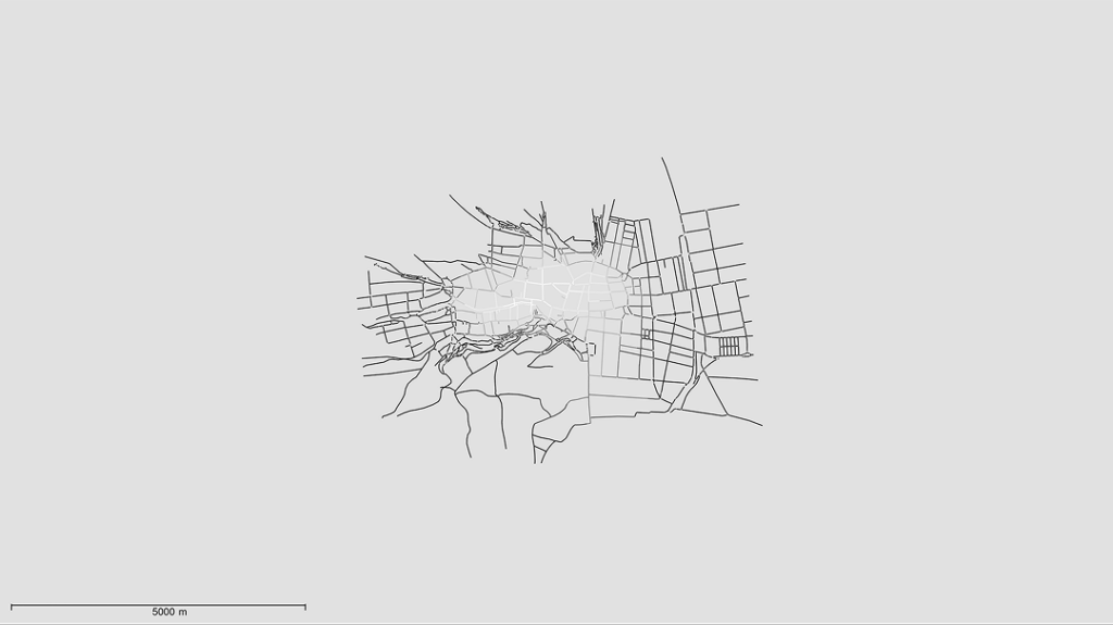
The 1895 plan proposed a more systematic approach to Miskolc’s road network. Advocating the regulation of existing roads, the creation of new streets, and cutting through larger urban blocks, the plan aimed to preserve the natural alignment of the ring road while addressing the issue of alleys. It is evident that the integration of the road network became more balanced, largely due to the elimination of alleys and the creation of new streets in the Gordon area, which completely eradicated the former network of alleyways. The area with the highest level of integration shifted westward towards Nagymajor Street, which was also identified in Palóczi’s plan as the route for the proposed ring road. The plan also includes the development of streets along the Pece creek, while the previously accessible Népkert (public park) is now disconnected from the city’s road network.
Higher-integration roads are thoroughly connected to a broader transportation network, such that the improved connectivity can enhance social interaction and provide better access to various destinations, facilitating movement. For this reason, it was proposed to create a structure with fewer areas of low integration, which could later develop into segregated areas.
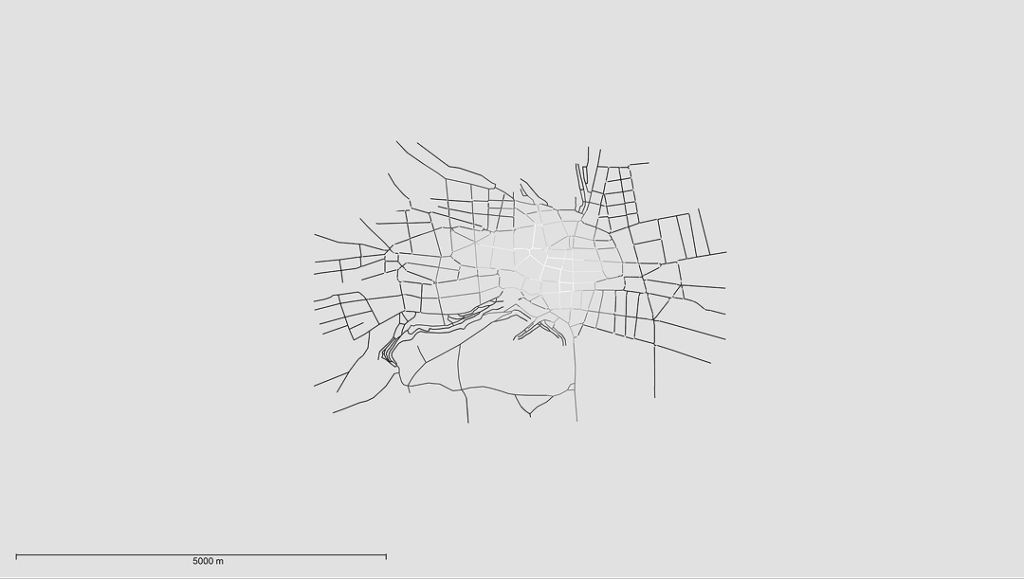
Palóczi’s plan in 1897 was proposed for a complete transformation of the city’s structure, resulting in a balanced level of integration across the city. This plan involved eliminating alleys and cul-de-sacs, while also integrating the winding road network of the Avas hill into the city centre. The plan shows the Pece creek, but with new streets and urban blocks replacing the stream itself. A green space was also created along the Szinva creek, with streets running parallel to the river to ensure integration. The line of the proposed ring road with the new diagonal roads in the surrounding incised the connectivity of the roads thus created a more balanced integration of the structure.
Palóczi already highlighted the significance for public health of the green area along the Szinva in the Miskolc plan. The plan shows the established connections between the green spaces, assigning specific functions to each (parks, promenades, playgrounds, sports facilities). In 1908, he emphasized the importance of public parks and smaller green spaces (plantations) being easily accessible to all city residents and located within a short distance.83 All of these urban components were eventually realized in the case of his Miskolc plan and can even be discerned in the isolated parks along the Attila ring road in Buda.
While the plans displayed innovative features, such as the arrangement of green areas, the configuration of streets, and the design of urban blocks, they were never accomplished in real life, and the later urban plans for the two cities diverged significantly from Palóczi’s solutions.
The research was supported by the University of
Debrecen and the Hungarian Scientific Research Fund
(Grant no. K_142121).
PALÓCZI, Antal. 1897. Miskolc rendezett tanácsú városának szabályozása. Mérnök- és Építész Egylet Közlönye, 31(6), pp. 259–263, here p. 259.
Also known as Platzer and Palóczy.
LOVRA, Éva. 2019. The Forgotten Urbanist Antal Palóczi. Architektúra & urbanizmus, 53(3–4), pp. 212–223.
The members of the committee were Lajos Lechner, minister councillor, former director of public works of the Budapest city hall, Ferenc Devecis, the technical councillor of the Budapest city hall, Imre Francsek, architect and royal chief engineer, József Mihályfi, chief engineer of the Budapest city hall and Antal Palóczi, architect and teacher.
For more details on the urban plan see: LIPPAY, Béla and ADLER, Károly. 1895. Emlékirat Miskolcz város szabályozása tárgyában. Javaslat. Miskolc, pp. 1–17; On the analyses of the plan: IGLÓI, Gyula. 1991. Dokumentumok Miskolc 19. századi városrendezésének történetéből. A Miskolci Herman Ottó Múzeum Közleményei, (27), pp. 69–74; DOBROSSY, István. 2002a. Miskolc írásban és képekben 9. Miskolc: Miskolci Idegenforgalmi és Kulturális Iroda – Borsod-Abaúj-Zemplén Megyei Levéltár, p. 326; DOBROSSY, István. 2002b. Miskolc 19–20. századi városrendezési tervei és megvalósulásuk. Herman Ottó Múzeum Évkönyve, (41), pp. 171–206; DOBROSSY, István and OLAJOS, Csaba. 2003. Városfejlődés, városépítészet. In: Dobrossy, I. (ed.). Miskolc története IV: 1849-től 1918-ig. Miskolc: Borsod-Abaúj-Zemplén Megyei Levéltár – Herman Ottó Múzeum, pp. 195–277.
Palóczi, A., 1897, p. 259.
STÜBBEN, Josef. 1890. Der Städtebau. Braunschweig, Wiesbaden: Vieweg.
SITTE, Camillo. 1889. Die Städtebau nach seinen künstlerischen Grundsätzen. Wien: Graeser.
WAGNER, Otto. 1911. Die Großstadt. Vienna: Schroll-Verlag.
PALÓCZI, Antal. 1903. A városépítő művészetről. Művészet, 2(3), pp. 173–182, here p. 174.
STÜBBEN, Josef. 1911. City Building. Part 3, p. 54. Available at: https://socialsciences.uchicago.edu/department/urbanism-lab/joseph-stubbens-city-building (Accessed: 11 July 2024).
Stübben, J., 1911, part 2, p. 19.
See more: MORAVČÍKOVÁ, Henrieta, SZALAY, Peter, HABERLANDOVÁ, Katarína, KRIŠTEKOVÁ, Laura and BOČKOVÁ, Monika. 2019. (Un)Planned Bratislava. Bratislava: Department of Architecture, Institute of History, SAS; MORAVČÍKOVÁ, Henrieta, PASTOREKOVÁ, Laura and LOVRA, Éva. 2020. Antal Palóczi and the beginnings of modern urban planning in the Kingdom of Hungary: the example of Bratislava and Novi Sad (1867–1918). Planning Perspectives, 35(2), pp. 371–381; MORAVČÍKOVÁ, Henrieta, LOVRA, Éva and KRIŠTEKOVÁ, Laura. 2020. The beginnings of modern town planning in the Kingdom of Hungary: the cases of Bratislava and Novi Sad. Historický časopis, 68(6), pp. 977–990; MORAVČÍKOVÁ, Henrieta, LOVRA, Éva and KRIŠTEKOVÁ, Laura. 2019. Začiatky moderného mestského plánovania v Uhorsku. Prípad Bratislavy a Nového Sadu. Historický časopis, 67(3), pp. 467–480; MORAVČÍKOVÁ, Henrieta, PASTOREKOVÁ, Laura and LOVRA, Éva. 2018. Unintentional Continuity: Development Parallels of Early Modern Urban Planning. In: 15th International Docomomo Conference. Ljubljana, 28–31 August 2018. Ljubljana: DOCOMOMO International, pp. 630–632; MORAVČÍKOVÁ, Henrieta, LOVRA, Éva and PASTOREKOVÁ, Laura. 2017. Červený alebo modrý? Začiatky moderného plánovania Bratislavy. Architektúra & urbanizmus, 51(1–2), pp. 30–43.
Palóczi, A., 1897, p. 260.
The need to subdivide the blocks of buildings was also pointed out by Sitte and Stübben, as well as the local urban architects of the time, since mega-blocks did not allow for adequate ventilation of the dwellings, resulting in enclosed courtyards, suffering from darkness and damp. This proposal was also important from a public health point of view, as the subdivision could have been a barrier to infectious diseases.
Palóczi, A., 1897, p. 262.
Palóczi, A., 1897, p. 260.
The members of this committee were Lajos Lechner, minister councillor, former director of public constructions of Budapest, Ferenc Devecis, technical Councillor of Budapest, Imre Francsek, architect and royal chief engineer, József Mihalyfi chief engineer of Budapest and Antal Palóczy, architect and teacher.
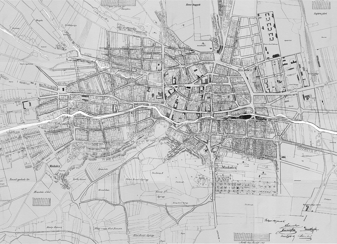
The first urban planning map of Miskolc. Printed on paper, in colour, with the zoning lines indicated in colour. Date: 1897. Restored in 1994. Dimensions: 95 x 140 cm. Inv. no. HOM HTD II. 1. Local History Documentary Library, Herman Ottó Museum, Miskolc.
Lippay, B. and Adler, K., 1895.
Dobrossy, J. and Olajos, Cs., 2003, p. 236.
HORVÁTH, Béla. 1958. Miskolc városépítés történetének vázlata. In: Horváth, B. (ed.). Miskolc városrendezési kérdései. Miskolc: Műszaki és Természettudományi Egyesületek Szövetsége Miskolci Intézőbizottsága, p. 123.
Dobrossy, J. and Olajos, Cs., 2003, p. 236.
Carved chair, the best-known object of Luca Day traditions (13 December). They start making it on Luca’s day, using several types of wood (usually 9), and they work on it every day just enough to make it ready for Christmas Eve.
RUTTKAY, Menyhért. 1897. Lucza-széke. Szabadság, 6(4), p. 3.
PALÓCZI, Antal. 1897. Miskolc rendezett tanácsú városának szabályozása. Mérnök- és Építész Egylet Közlönye, 31(6), pp. 259–263.
See note 14.
Plan published in 1897 in the publication of the Hungarian Engineers and Architects Association. The plan shows a prominent boulevard framing the central part of the city and a series of star-shaped squares, which are the intersections of 5–6 roads. Source: Palóczi, A., 1897, p. 261.
LOVRA, Éva. 2019. Hangsúlyváltozások: a várostervezés elveinek (át)alakulása Miskolcon 1920
után. In: Tamáska, M., Krcho, J., Sekan, J. and Szűts, I. G. (eds.). Változó szerepek, változó városképek: Kassa és Miskolc a 20. században. Budapest: Martin Opitz Kiadó, pp. 103–117.
PALÓCZI, Antal. 1909. Pozsony szabad királyi város szabályozásáról. Városszabályozási kérdések. Pozsony: Angermayer Ny., pp. 9–10.
Palóczi, A., 1897, p. 261.
Sitte, C., 1889, p. 267.
Palóczi, A., 1897, p. 261.
Palóczi, A., 1897, p. 261.
KÁLLAY, István et al. 1993. Bírósági épületek Magyarországon. Budapest: HG & Társa Kiadó, 220 p., here p. 110.
Palóczi, A., 1897, p. 262.
DOBROSSY, István (ed.). 2006. Miskolc írásban és képekben 1. 2nd ed. Miskolc: Dr. Dobrossy István, 296 p., here p. 60.
Szabadság, 1897, 6(85), p. 4.
Palóczi, A., 1897, p. 262.
Palóczi, A., 1897, p. 262.
PALÓCZI, Antal. 1908.
A mai városépítés alapelvei. Budapest: Pátria, p. 13.
A FKT hivatalos jelentése 1907. évi működéséről. 1908. III. Útépités. Budapest: Nyomtatott Heisler és Kózol Kő- és Könyvnyomdájában, p. 27.
Eskütéri híd – today
Erzsébet Bridge
MUDRONY, Soma. 1893. Budapest jövője. Budapest: Országos Iparegyesület, p. 19.
A FKT hivatalos jelentése 1885. évi működéséről. 1886. I. Szabályozás. Budapest: Nyomtatott Heisler J.-nál.
A FKT hivatalos jelentése 1899. évi működéséről. 1900. Budapest: Nyomtatott Heisler J. Kő- és Könyv- nyomdájában, p. 78.
A FKT hivatalos jelentése 1901. évi működéséről. 1902. I. Szabályozás. Budapest: Heisler J. Kő- és Könyvnyomdája, p. 7.
Öl officially bécsi öl – about 1.896483840 m.
A FKT hivatalos jelentése 1906. évi működéséről. 1907. III. Útépités. Budapest: Heisler J. Kő- és Könyvnyomdája, p. 26.
Name alternatives: Devecis Ferenc, Devecits Ferencz, Devecis Ferencz.
PALÓCZI, Antal. 1907a. “Uj Boulevard” a jobbparti városban. Mérnök- és Építész Egylet Heti Értesítője, 26(17), p. 185.
Today at the juxaposition of Krisztina and Árpád ring roads.
Építő Ipar. 1907. Vegyesek. Építő Ipar, 31(18), p. 179.
A Fővárosi Közmunkák Tanácsának hivatalos jelentése 1907. évi működéséről. 1908. III. Útépités. Budapest: Nyomtatott Heisler és Kózol Kő- és Könyvnyomdájában, Budapest, p. 52.
Fővárosi Közlöny. 1907. A tanács előterjesztése az 1. ker. Attila-és Krisztina-körut kiszélesítése ügyében hozott közgyűlési határozatra (Előadó: Kun tanácsnok). Fővárosi Közlöny, 18(37), pp. 948–952.
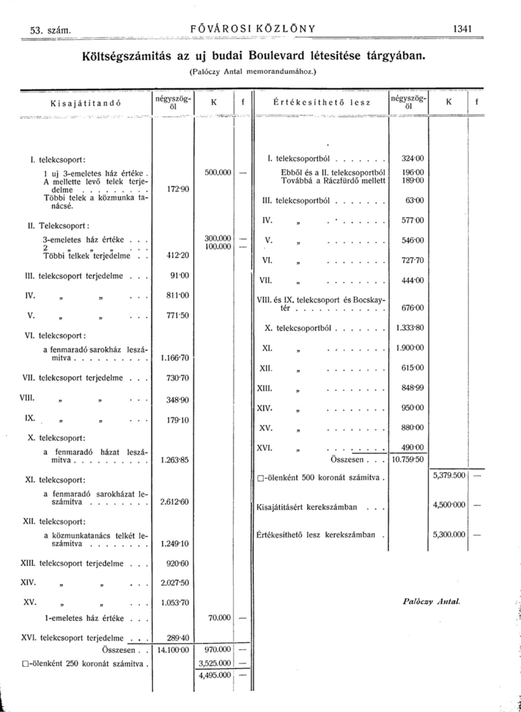
PALÓCZI, Antal. 1907b. I. Palóczy Antal beadványa. Fővárosi Közlöny, 18(53), pp. 1340–1342, here p. 1340.
LOVRA, Éva. 2020. Budapest legfontosabb városmorfológiai változásai (1867–1918) a szabályozásokon és esettanulmányokon keresztül. Építés – Építészettudomány, 48(1–2), pp. 113–145.
Magyar Ipar. 1907. A budai körutak rendezése. Magyar Ipar, 28(19), pp. 453–454.
PALÓCZI, Antal. 1907c.
A budai körut. Magyar Ipar, 28(19), pp. 464–469.
Palóczi, A., 1907c, p. 466.
Known in Hungarian as Rác-templom.
A Fővárosi Közmunkák Tanácsának hivatalos jelentése 1907. évi működéséről. 1908. I. Szabályozás. Budapest: Nyomtatott Heisler és Kózol Kő- és Könyvnyomdájában, p. 25.
A Fővárosi Közmunkák Tanácsának hivatalos jelentése 1907, évi működéséről. 1908, p. 25.
Palóczi, A., 1907b, p. 1340.
Palóczi, A., 1907b, p. 1340.
Palóczi, A., 1907b, p. 468.
Palóczi, A., 1907a, p. 185.
Pesti Hírlap. 1907. A főváros művészi kiépítése. Pesti Hírlap, 29(137), p. 9.
DEVECIS, Ferenc. 1907. II. Devecis Ferencz műszaki tanácsos javaslata. Fővárosi Közlöny, 18(53), pp. 1342–1351.
HEUFFEL, Adolf. 1907. III. Heuffel Adolf középítési igazgató javaslata. Fővárosi Közlöny, 18(53), pp. 1351–1356, here p. 1353.
KUN, Gyula. 1907. IV. Kun Gyula: A tan. III. ügyosztály előterjesztése. Fővárosi Közlöny, 18(53), pp. 1356–1357, here p. 1356.
PALÓCZI (Palóczy), Antal. 1908. A 30 m. szélességben tervezett budai új körút – a mérnöki hivatal tervével összevonva. Inv. no. FSzEK BT 392. Metropolitan Ervin Szabó Library, Budapest.
Palóczi, A., 1908.
PALÓCZI, Antal. 1912.
A budapesti Tabán szabályozása. Építő Ipar, 36(11), pp. 107–109.
Palóczi, A., 1912, p. 107.
Palóczi, A., 1912, pp. 108–109 and PALÓCZI (Palóczy), Antal. 1908. A 30 m. szélességben tervezett budai új körút – a mérnöki hivatal tervével összevonva. Inv. no. FSzEK BT 392. Metropolitan Ervin Szabó Library, Budapest.
ÚJF. 1911. Fiuméból. Építő Ipar, 34(12), p. 114.
Palóczi, A., 1908, p. 6.
PALÓCZI, Antal. 1903. A városok rendezése: Budapest viszonyainak egybevételével. Budapest: Magyar Mérnök és Építész Egylet, pp. 26–27.
PAPP, Ferenc et al. (eds.). 2015. Miskolc régi térképeken 1759 – 1963. Miskolc: Miskolc Megyei Jogú Város Önkormányzata, pp. 62–63.
Papp, F., 2015, pp. 70–71.
UCL SPACE SYNTAX. 2024. Glossary [online]. Available at: https://www.spacesyntax.online/term/integration/ (Accessed: 8 August 2024).
Palóczi, A., 1908, p. 13.
DOI: https://doi.org/10.31577/archandurb.2023.57.3-4.5

This work is licensed under a Creative Commons Attribution 4.0 International License