South Buda (11th district of Budapest), as an artificially designed district, displays a revealing combination of urban design tendencies at the turn of the previous century. Its development was preceded by a multi-stage urban planning process in which the ring-radius idea, the network and early garden city ideas emerged in interaction with each other. The paper deals with the urban characteristics at multiple levels of scale, the appearance of urban planning concepts and the evolution of the urban fabric. It primarily examines the impact of international and domestic trends in the history of ideas, and how contemporary concepts affected the realization process of urban development.
Introduction
“New Buda”, today’s 11th District of Budapest, began to develop on the southern Buda side of the Danube at the turn of the previous century. As such, it is the largest area of Budapest where development could start without precedent, and following a unified urban plan. As a deliberately designed district, it shows a revealing combination of European urban design tendencies of the period, where the imprints of centralized and networked ideas can still be found in the urban structure. The quarter of the city gradually developed in the first decades of the twentieth century with the southern growth of Buda along the Danube. This gradation is also recognizable in the evolution of its urban fabric: while the early inner blocks still show the inner-courtyard morphology of the 19th century, later additions already used the more spacious “connecting courtyard” and “cour d’honneur” forms prevalent in tendencies of stylistic pluralism. By the 1930s, modern urban design had an impact, often intertwined with historical patterns of civic culture in neighbourhood units. The modernization of the urban fabric continued in the constructions after the Second World War. The fabric of the city reveals an autonomous developmental process that allows for modeling of the interaction of the tendencies in the history of ideas. Additionally, the paper addresses rehabilitation programs and late modern additions to the fabric in the second half of the twentieth century.
During the investigation, we address the question of the centrality and continuity of urban rings: how the positions and characters of this urban traffic form became interpreted in the changing planning environment. We analyze the city plans by comparing the idea of the design and the realization, aiming to uncover how classical urban design influenced it, primarily the ring-radius idea
yet equally the increasingly evident networked concept of modernity and the idea of the garden city.1 The large-scale, free area provided an opportunity to formulate comprehensive urban structure visions, and as a result, it is possible to examine the plans in the historical context of urban design of the time, and to demonstrate the period’s impact mechanisms. At the same time, the protracted implementation, spanning several decades and eras, likewise provides an opportunity to draw out the contradictions between the idea and the realization. First, the study presents the plan versions developed for the areas of Kelenföld and Lágymányos in the context of Budapest’s ring-radius urban structure. After the conceptual evaluation of the plans, it presents the long process of realization, the transformation of the morphology, and the distortions that occur in the urban structure along the extensive ring stratification of urban development.2
The primary sources of research sources are the original archival design history documents found in archives. Plan versions representing the starting point of urban development could be found in the Budapest City Archives. The materials of the design tenders and the layout plans provide insight into the original ideas, supplemented by contemporary professional publications. The literature sources provided additional clues for the research. Ambrus Seidl and János Gerle also dealt with the history of the district in their studies, but the city structure has not yet been examined in detail.3 The urban design analysis was based on previous research of the BME Department of Urban Planning and Design, yet notably as well the publication on the history of the department.4 Since the university itself played a decisive role in the development of the South Buda district and the staff of the department actively participated in the preparation of town planning plans, this historical information provides an opportunity to reconstruct the historical processes of planning.
The Context of the Planning History: The Ring-Radius City Model after the Unification of Budapest
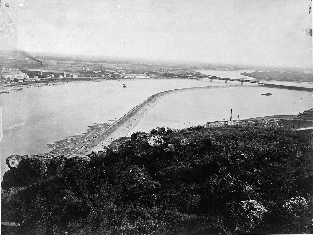
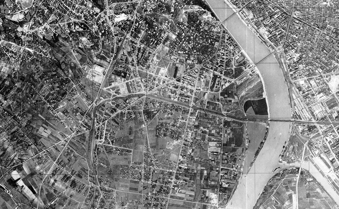
The development history of South Buda should be examined in the broader context of the city in order to understand the spatial and temporal connections of the city structure. After the unification of Pest, Buda and Óbuda in 1873, the urban structure of Budapest was built on the basis of the ring-radius model of classical urban design.5 The areas of South Buda were undeveloped for a long time, and only at the turn of the century, after the regulation of the Danube coastline and the draining of the swampy area, did they gradually begin to be developed. Although the construction of the Pest side progressed more quickly after the city unification, the unprecedented openness of the South Buda areas made it possible to build according to plan. As a result, this area became Budapest’s largest planned urban structure unit.
Budapest’s ring-radius city structure was created by the representative spatial layouts of European cities: the patterns of Parisian boulevards and Vienna’s Ring influenced Budapest’s plans as well. However, due to Budapest’s topographic features, the rings could not close properly and were built primarily on the Pest side, which is located in a flat area, while on the Buda side, the hilly terrain partially prevented or significantly distorted the route. First, the inner small circuit, the present-day Kiskörút [Small Boulevard] was formed on the outer site of the medieval city wall of Pest. The next ring, Nagykörút [Grand Boulevard], was itself a result of the development following the 1873 city unification and hence a work of conscious planning. The plan of the boulevard was prepared by the newly established Capital Public Works Council: founded in 1870, it was created to plan and supervise Budapest’s public works, preparing the city’s layout plans and building regulations and operating as a second-level building authority. Subsequently, the second ring was built in several stages between 1872 and 1896. The boulevard led from the Margit Bridge in the north to the Petőfi Bridge in the south, though only realized much later, in 1937, passing the Nyugati [Western] railway station and intersecting the radial roads leading out of the city (Váci Street, Andrássy Street, Rákóczi Street, Üllői Street). The third ring road is Hungária körút, which the Capital Public Works Council proposed as early as 1872, based on Lajos Lechner’s plan submitted to the merging Greater Budapest urban development tender in 1871. However, the plan was only completed for the semi-circular section in Pest: no continuation was ever planned on the Buda side, so at both ends it collided with the Danube for a long time. Although the boulevard was not completed by the originally planned year of 1896, to commemorate the millennium anniversary of the Hungarian state, its location was already in place. Nevertheless, at its southern end, the area was partially built-up, so its alignment was distorted during the implementation.
These changes and amendments to the ring also parallel the construction and morphological character of the city. In the construction wave that started in the second half of the 19th century, Pest became densely built up. The characteristic building form was the tenement house organized around a narrow inner courtyard, where the more affluent social strata lived on the street front, in the two-section wide, better sunlit apartments, and the poorer tenants in the narrower side wings facing into the courtyard, in simple one-room-plus-kitchen apartments.6 This construction method extends from the inner districts to the areas beyond the Nagykörút, yet in most cases never reached the line of the Hungária Ring Road.7 With their historicist facades, the new buildings give the Kiskörút and the Nagykörút a striking visual character and solid frame. By contrast, the surroundings of the Hungária Ring Road were realized later, from a functional and morphological point of view involving mixed construction, hence this road primarily serves as a traffic artery, and never developed the character of a representative boulevard. The ring structure of the city is reinforced by two additional ring roads of the railway network, to which the other elements of the road network have also been partially adapted.
Based on this outline, we can see that the ring structure of the city structure was primarily planned for the Pest side, while no continuation was prepared for South Buda. The development of the Pest side progressed almost at the same time and in parallel with the planning process of South Buda, but at the same time the integration of Pest was realized much faster. Considering the time-lag in the development of South Buda was delayed in time, the bridges built in the meantime at the end points of the Pest rings came to form new connection points.
The First Urban Planning Concepts: Ideal Plans and Adaptations
The development of the urban structure of Kelenföld was influenced simultaneously by two of the main urban-architectural trends of the turn of the century: the ring-radial layout of the classical urban concept and the network (orthogonal grid) structure of modernity. The position of the almost flat, undeveloped area along the Danube made it possible to continue the ring-radius city structure on the south Buda side, while the framing of the landscape by the river and the hills suggested the use of a structure with an independent center. In 1870, the newly founded Council of Public Works of the Capital City began to organize the Danube banks, where the landscaping and infill of the previously swampy area resulted in a nearly flat tabula rasa, giving a great degree of freedom for the design. The only extant influences on this starting point were the route of the railway ring planned and completed in 1877 and the axes of the regional roadways leading out of the city. Precisely this openness is what makes the district special in the urban development of Budapest: the newly developed area was able to develop following a unified plan due to the absence of layers of previous buildings.
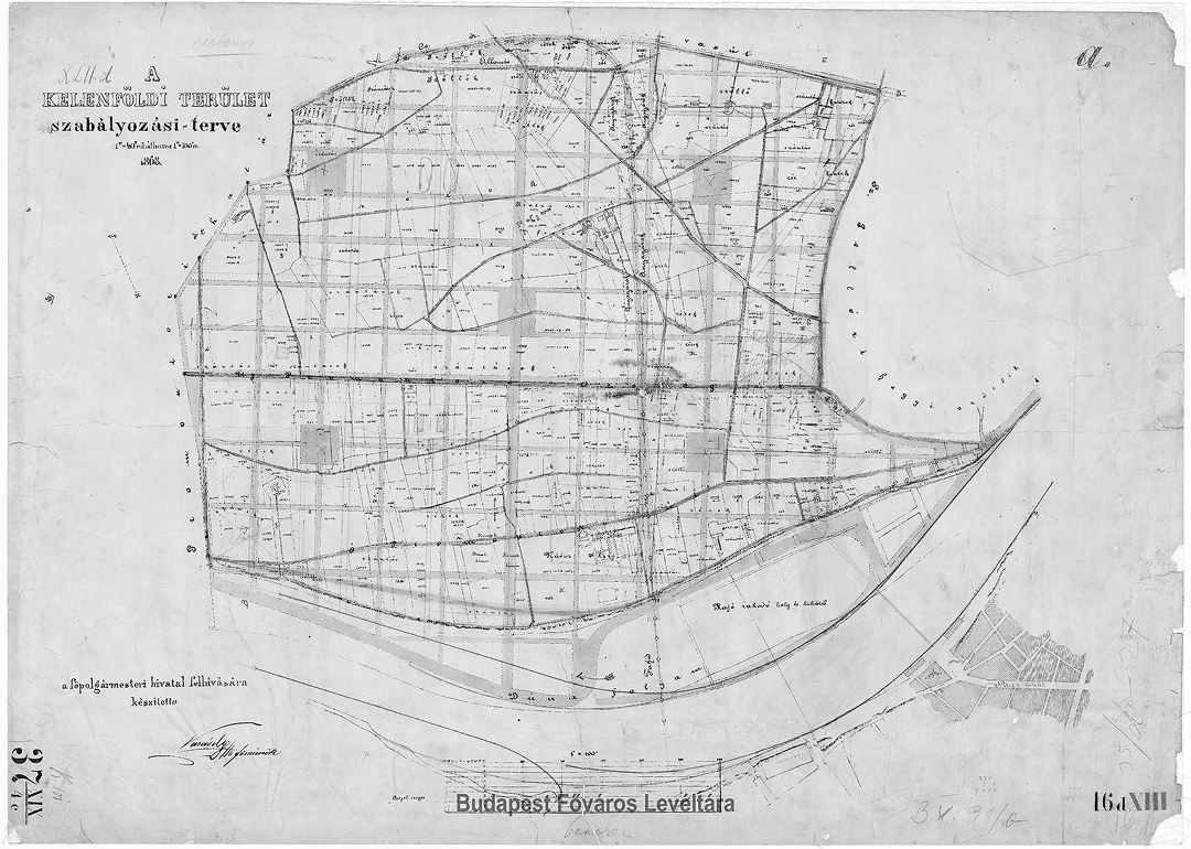
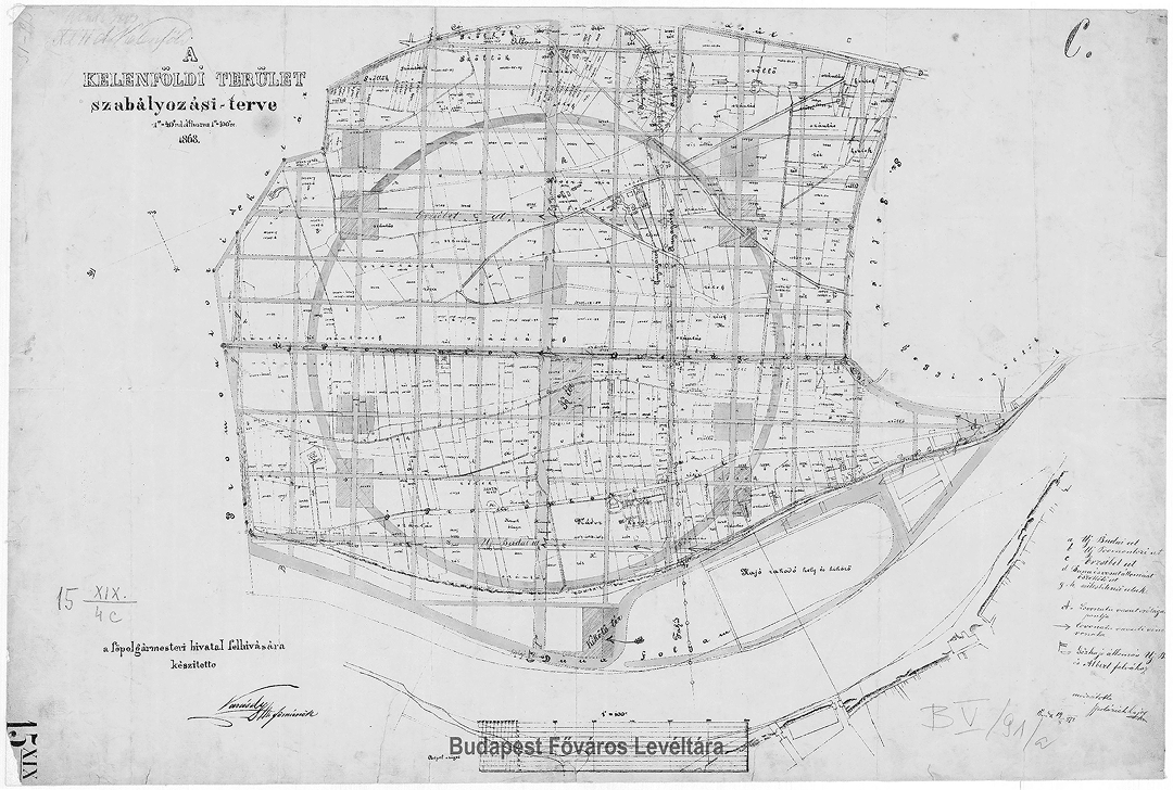
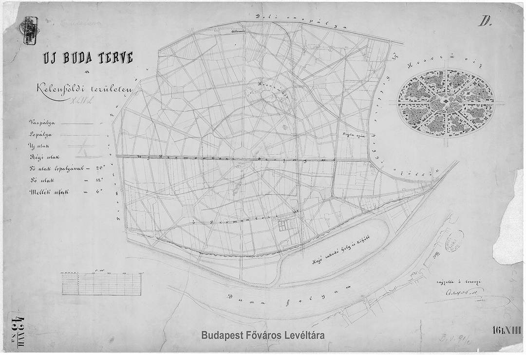
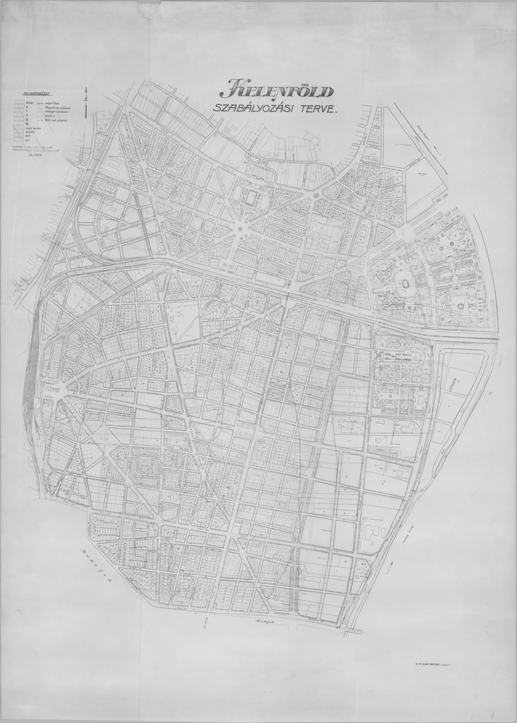
The first layout plans were completed in 1868 on behalf of the mayor’s office.8 The first plan was drawn up by Lipót Varásdy and projected an orthogonal grid onto the area, bisected in the middle by the main road running in two main directions and assuming prominent role: the main route running from the Kelenföld railway station to the Danube bank and the national road leading out of the city, where the intersection with the present Fehérvári Street designated a new center to the area.9 In the other five fields of the net, he proposed a park green area. This basic network was used and developed further by the C version made by Lajos Spolarich in 1871.10 The importance of the center marked by the axial cross was confirmed by the circuit that runs around the area. He widened the main roads and designated public spaces at the intersections with the boulevard. The undated version D, written by Adolf von Toth, developed an autonomous, spiderweb-like structure.11 The organically woven net kept the center of the previous plans, although the weave of the ideal plan was crossed by the existing national roads without modification.
The first designs still sought a clean application of the ideals of the adaptation. The centers of the constructions appear in the focus of the city district (and not in the historical focus of the entire city of Budapest), and thus can be interpreted as an effort to realize a kind of ideal city idea, forming the situation of an independent, “city within the city”. On one plan, amended to match the center of the area, a ring-radius (spider web) editing appears, on the other, an orthogonal grid. However, these plans were even less adapted to the conditions of the area, hence it was necessary to combine the methods for their alteration. An important step in this was that, although the area is almost flat, allowing for purely geometric constructions, the central city structure of Budapest on the scale of the whole city attracted the epicenter of the new part of the city to the existing center.
The regulation plan of Buda was adopted in 1876, launching in parallel the consolidation of the structure of South Buda.12 The layout combined the grid layout created by Lipót Varásdy with the concept of a park-like, intensive green space system. He preserved the expansions created in the junctions that appeared in later versions, for which he created a characteristic arched space wall. These square walls are still present today and strongly characterise the public spaces of the district. In addition to the tools of classic urban design, experiments with new urban architectural trends already began to appear on the plan versions. Behind the idea of representative boulevards and avenues, a more decentralized grid arrangement is emerging, closely resembling Ildefons Cerdà’s Barcelona plan (1857). In turn, the intensive presence of green areas and the solitary arrangement of buildings evoke an early ideal of a garden city – yet despite the appearances, the design is not related to Ebenezer Howard’s concept, since it was only published later in 1898. Considering the experimental approaches and the combination of adaptation principles pointing in a modernist direction, the plan can be considered a forward-looking solution.13
Among the parallels in Hungarian planning history, the only similar solutions happen to date from later periods. Although the layout of the Wekerle Housing Estate designed by Ottmár Győri on the Pest side is often compared to that of the early 20th century, the size of the estate is much smaller, and moreover, no regulation plan for private investment was ever prepared for the area: its plan is of a housing estate intended for state development. During this period, colonies were also created according to similar design principles on the shore of Lake Balaton,14 where the network and diagonal arrangement, along with the invocation of the garden-city ideal, can be related to the planned subdivisions in Budapest. However, in this case, it was the middle-class, intellectual society of South Buda who typically bought a vacation home on the shores of Lake Balaton in addition to the capital-city apartment, thus making up for the garden experience missing from the city. This social stratum was the one most numerically represented in the communities of the holiday settlements of the time.
The Consolidation of Urban Planning Concepts
The consolidation of planning concepts and the adaptation of the new building forms that appeared in the meantime are linked to the architect László Warga, active in the first half of the century.15 From 1910, he worked at the Urban Planning Sub-Department of the Capital City, where he first addressed the planning plan of Kelenföld in 1913. His life path also connected him to the district: after his years at the University of Technology, he bought an apartment near the university, and in 1929 he became the founder of the University’s Department of Urban Planning. Assuming a significant role in the spread of new forms of urban constructions, Warga was, thanks to his international knowledge, familiar with European trends, and personally recommended the use of the connecting courtyard construction instead of the English townhouse construction pattern popular at the time. Unlike the previous Budapest apartment block with its narrow inner courtyards, in the new development the buildings standing in closed rows on the street front create a frame around the common area of spacious, sunny inner courtyard.16 This installation can already be evaluated as a step towards modernity, which was also accompanied by a social reorganization: the residents were no longer renters, but lived in their own apartments.**key=17 In his later planning application, he already used the modern, free-standing “strip house” construction in the area previously regulated by the adjoining courtyard construction.**key=18**
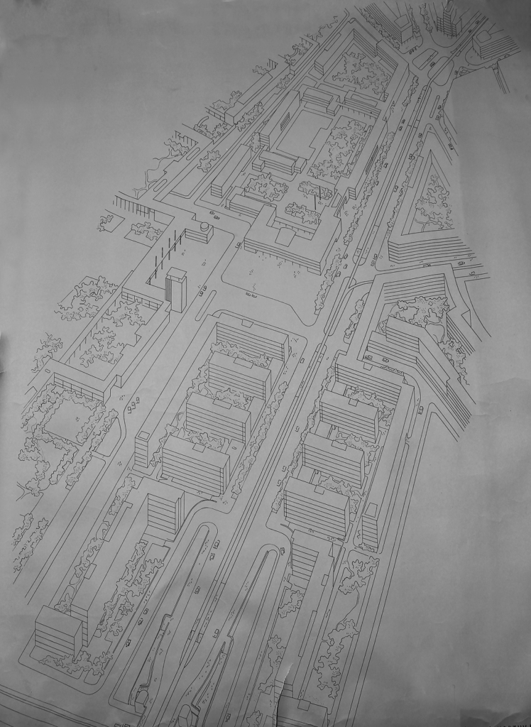
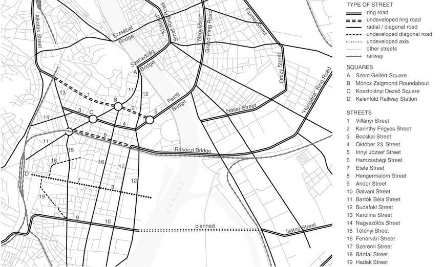
In 1930, Warga prepared his detailed layout plan using these building forms of connected courtyards for the area of Kelenföld, which in 1934 became the independent District XI.19 On the plan, we can also observe the consolidation of the urban structure following the previous ideal plans, which provides an opportunity for a detailed analysis of the structure of the district formed in the 1930s. The independent inner center designated by the axial cross in the earlier plans remained, but its role became irrelevant. Instead, extensive effects can be observed that undeniably resulted from the ring development of Budapest. Considering that the district was built outward from the historical center of Budapest, moving from north to south, as a result, the center of the district also shifted to the north. The network and the diagonal roads sought connection points with the boulevards of Pest, while the fabric of roads formed from the interstitial streets and diagonal arteries created alternative directions for the continuation of the traffic routes. The trajectory of the Small Ring Road of Pest crossed over Buda via the Ferenc József Bridge (Szabadság Bridge) only to collide with the mass of Gellért Hill, while in the case of the Grand Ring Road, once the Horthy Miklós Bridge (Petőfi Bridge) was completed in 1937, it was possible to continue the circuit to today’s Karinthy Frigyes Street-Villányi Street and Bocskai Street-Karolina Street routes, although in the inner areas the Buda hills also had a distorting effect on the ring structure. The nature of the boulevard is also indicated by the previous names: the name of Karinthy Frigyes Street was still Budai körút [Buda Ring Road] at the beginning of the century, and the name of Villányi Street between 1929-53 was Prince Szent Imre Boulevard. The plan also counted on a connection with the Hungária Ring Road, where the route of Hamzsabégi Street laid out along the ring railway would have become a spacious section of the third ring, accompanied by rows of trees, but it was never built. The reason for this failure was, on the one hand, the absence of a bridge over the Danube (it was only completed in 1995), and on the other hand, the construction of Lenke Street (Bocskai Street) running parallel to Hamzsabég Street with a larger capacity than planned, which was already the subject of many disputes.
The ring structure of the city was strengthened not only by the boulevards, but also by its railway network. The southern circular railway has been an important link in the railway network since the 1870s, ensuring that the railway line passing through Kelenföld became a decisive structural element in the development of the new city structure. The radial roads were marked by the axes of the former national roads starting from the city, with Fehérvári Street, Promontor Street (Budafoki Street) and Budaörsi Street marking the radial axes. Retained to form the characteristic elements of the 1930 plan are the original circular squares planned at the intersections of the axes; the new building forms were also adapted to the curved exterior walls. Park-landscaped public spaces and a vision of a tree-lined promenade leading out of the city likewise were preserved from the garden city concept; further, the plan recommended a lower-density garden city development in the outer zones.
Hence the layout plan of 1930 shows a more complex arrangement, in contrast to the ideal plans: in addition to the representative axes and circular spaces of classical urban design, the modern grid arrangement and new forms of installation also appear. Although the main intersection of Fehérvári Street with Etele Street, the latter forming the representative axis from Kelenföld railway station to the Danube bank, remained the focus of the area, the north-south expansion of the city district and the connections with the Pest rings show the extensive impact of Budapest’s ring development. This underlying pattern is visible in the alterations to the complex role of diagonal roads. An example of this is Bartók Béla Street, which used to be called Átlós [Diagonal] Street, but was also considered the main road leading out of the city to Körtér [Circular Square], part of Fehérvári Street. The combination of straight and diagonal grid directions gave the opportunity for connections to the existing urban structur. This construction does not display a shape derived from the earlier curved ring boulevards but an integrated morphology emerging from the combination of the orthogonal grid and diagonal constructions, where the rings themselves are not curves but instead polygons composed of diagonal and grid elements. All of this made it possible to build the construction from the epicenter of Budapest, from north to south, in ring layers, which also appears in the morphological layers.
The Process of Realization: Extensive Layering of Urban Structures
Inner Core Area
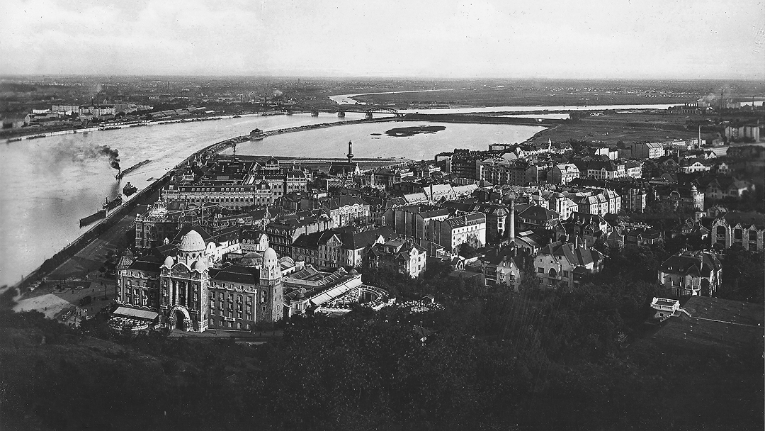
In relation to historical periods, the morphological evolution of the area can be divided into three large zones. Development started from the southern side of Gellért Hill and progressed gradually from the north toward the previously undeveloped flatlands of Kelenföld and Lágymányos. With the opening of the Szabadság [Freedom] Bridge, then known as Franz Joseph Bridge, in 1896, the area around Szent Gellért Square began to develop first. As a continuation of the bridge, the present-day Bartók Béla Street, which was built on the site of the former country lane, became the main thoroughfare of the area. Along the inner sections of the radial roads, inner-courtyard buildings were the first to be constructed, following the typical urban housing form of the Pest side.20
Starting in the first decades of the twentieth century, and increasing during the interwar period, a shift took place toward modern urban built forms that allowed for more sunlight. This change implied a new morphology of the connecting courtyards, no longer built between inner wings, but open toward on the street frontage. The cour d’honneur designs, sometimes even cutting through blocks and creating inner streets, resulted in more dynamic streetscapes.21 In the inner areas, the morphology of inner courtyard, cour d’honneur and connecting courtyard appeared in a mixed manner. Until the First World War, a cohesive urbanized area existed only along the inner sections of Budafoki Street and Bartók Béla Street.22 After the First World War, in the 1920s, construction continued along the present-day Villányi, Bartók Béla, Karolina, Bocskai, and Fehérvári streets, as well as in their intersecting side streets. In the outer areas, which had been developed in the interwar period, whole blocks with connecting courtyards were built.23
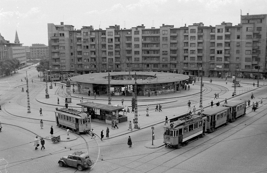
As envisioned in the early ideal plans, the area is characterized by the system of wide boulevards and avenues, as well as circular squares at their intersections. Of these squares, Szent Gellért Square also fits into this system as the bridgehead of the Szabadság Bridge, while Móricz Zsigmond Square and Kosztolányi Dezső Square were developed later, between the two world wars. The distinctive concave street frontage at Móricz Zsigmond Square was built between 1934 and 1936, based on the plans of Zoltán Révész. This feature is additionally connected to one of the notable works of Budapest’s interwar architecture, the residential palace and cinema designed by Gábor Preisich and Mihály Vadász. József Fischer, who designed many buildings in the district, envisioned Móricz Zsigmond Square as a district center with several public institutions. Although these plans were not realized, kind of local center emerged after the Second World War at the corner of Fehérvári Street and present-day Október 23. Street. The polyclinic was built in 1949 based on the designs of Jenő Szendrői and Andor Lévai, while the “Skála” department store (István Kovách) and the market hall (György Halmos) were constructed in the 1970s.24
At the end of the 19th century, an elegant villa district arose on the southern slopes of Gellért Hill, which also contributed to the garden city vision of the district. During the interwar period, the proximity of the Technical University made the area attractive to the educated middle class. At this time, multifamily apartment-villas began to appear on the hillside, which were more suited to the modern, intellectual lifestyle than traditional tenement houses. István Fischer, himself a strong promoter of the apartment villa, is credited with the design of several of them in the district.25 Construction of this residential typology continued after the Second World War, with notable examples being the houses designed by Olga Mináry and the Bertalan Horváth – Éva Spiró design partnership26, which utilized modern forms that respected the traditional building types and the topography of the area.
However, this same hilly topography implied that the Buda-side ring road was realized in a significantly distorted form. The southern section began to develop from the 1920s along Villányi Street, at the foot of Gellért Hill: characteristically, villa developments occupy the hill side and perimeter blocks the southern side. Complementing this situation is an addition to Villányi Street is the housing estate from the 1950s: although the external design of the buildings shows the historicist decor of socialist realism, the composition points towards a more modern, looser layout.27 However, the housing estate also blocked the diagonal street that originally led from Kosztolányi Dezső Square into Villányi Street.
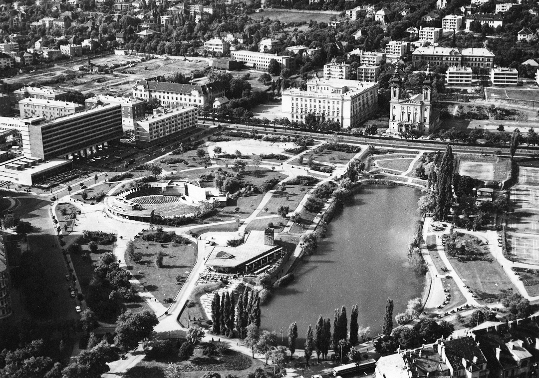
The most grandiose urban composition of this street section was realized around Feneketlen [Bottomless] Lake. On its northern side, Gyula Wälder designed an imposing twin-towered church, flanked by a grammar school on one side and a monastery on the other. Although the grammar school was built according to the original plans, the church was completed in a more modest form during the war years. The monastery, which was part of the symmetrical composition, was never built.28 Eventually, its place in the visual composition was assumed during the socialist period by the MSZMP (Hungarian Socialist Workers Party [Magyar Szocialista Munkáspárt]) educational center designed by István Balogh and János Molnár in the 1970s. The western edge of the park was also completed in the 1970s, with István Brejska’s design for the Sport Hotel, characterized by a strong modern form. Additionally, on the slopes of Gellért Hill along Villányi Street, the building complex of the University of Horticulture was constructed in several phases during the 1960s and 1970s, within a large park.29 As such, the section of Villányi Street towards Móricz square developed into a representative institutional zone.
For the area’s urban history, it is necessary to briefly mention the different development of the riverside zone. In the area created by the filling of the Danube bank, the campus of the University of Technology began construction at the beginning of the twentieth century. The first buildings of the pavilion structure faced the street, while the later ones opened onto the university gardens, creating an internal network.30 After the Second World War, the campus continued to develop on the southern side of Bertalan Lajos Street, maintaining this structure. Among the post-war constructions, the ensemble created at the bridgehead of the Petőfi bridge should be highlighted.31 This group recalls the squares seen in earlier ideal plans but was created with distinctly modern design solutions.
The inner areas were largely developed by the time of the Second World War, with an already established road network, though several intersections remained underdeveloped. The original concept for the square at the junction of Karinthy Frigyes Street and Irinyi Street was completed after the war. The vacant plots at Kosztolányi Dezső Square were also filled according to the original concept. With a relatively high quality of building stock compared to other parts of Budapest, post-war construction in these areas was limited to infill constructions. These buildings typically adapted to their surroundings, featuring street-frontages that follow the building method and the cornice heights of the neighbouring houses. Compared to the buildings constructed during the interwar period, these post-war constructions were characterized more by advancements in architectural design and technology rather than significant changes in their urban character. In terms of the streetscape, the most noticeable innovations were the somewhat larger and more numerous balconies and loggias compared to earlier buildings. Significant infill development occurred along Bocskai and Fehérvári streets. The post-war developments along Bocskai Street was designed by university professor Tibor Kiss and his department colleagues, which show a strong adherence to the surrounding patterns: with their peaked roofs and compact layouts, the new buildings essentially completed the perimeter blocks and the continuous, closed streetscape.32 The infill developments along Fehérvári Street during the 1960s and 1970s also adapted to the existing urban forms, but with a stronger emphasis on modern architectural expression.
Construction, in short, expanded outward from the Szabadság Bridge, which was the connection point to the ring road network of the Pest side. The first sections of the ring and radial roads retained the concept of wide and representative boulevards and avenues from the original urban plans. While at first the inner courtyard development appeared, this was soon replaced by increasingly modern types of built forms. As the change came quite soon, mixed areas appeared in the inner parts, while outwards can be seen whole blocks with connecting courtyards. Few significant changes in the urban fabric can be observed after the Second World War. The constructions, mostly confined to infill sites, largely completed the original urban concepts, with only a different approach to architectural form.
Middle Belt Area
The area between the continuation of the “Nagykörút” and the southern circular railway was primarily developed along Bocskai Street and its side streets until the Second World War. Closer to the bridge, much of the area remained undeveloped. Just as the Szabadság Bridge spurred the development of the inner zone, the Petőfi Bridge provided momentum for the middle area. In 1941, Bertalan Árkay designed a representative row of buildings in an Italian Novecento style along the road leading to the bridge; the design was ultimately realized, though in a more subdued form and only partially on the northern side.33 By the early 1960s, under the plans of Vilmos Henk, the northern side of the Karinthy Street junction was completed. The BME dormitory (Dénes Perczel, Pál Kisdi, 1966) also continues the original street concept, its cornice height and flat facade evoking earlier plans but incorporating distinctly modern solutions. However, at the bridgehead, the square was created with a decidedly modern design that broke away from this representative approach, marked by the construction of the university buildings. Schönherz Zoltán Street (Október 23. Street) also continued to be built up with closed spatial boundaries on the northern side after the Second World War. Notable buildings include Imre Kiss’s apartment block with its brick façade on the corner of Bercsényi Street and László Fodor’s office building on the corner of Budafoki Street.34 The latter’s corner design somewhat revisits the ideal of the representative squares, creating a generous square wall.
After the Second World War, the housing issue became an increasingly pressing problem in Budapest. To address this, residential developments began at various points across the city, primarily in areas close to existing urban fabric and well-served by infrastructure, but still undeveloped. Among those areas designated for development was Lágymányos, along the southern circular railway.35 While the first plan from 1953 included the formerly planned ring and radial roads36, some significant elements of earlier plans were built over. The diagonal connections from the 1930s plans, such as the road leading from Petőfi Bridge to Kelenföld railway station, were omitted. The new plan no longer included the continuation of Irinyi Street in this direction, instead it turned towards Október 23. Street-Bocskai Street direction, becoming solely a ring connection. The continuation of Szerémi Street past the railway belt and its intersection with Irinyi Street also remained undeveloped, despite being included in earlier plans.
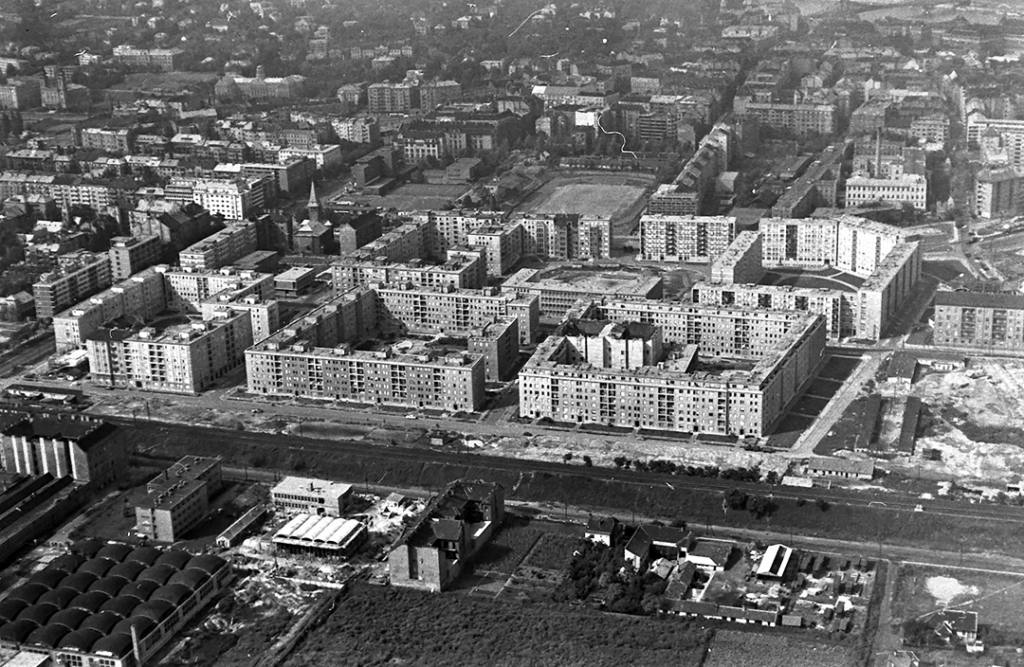
Before the Second World War, attempts at modern slab and point block developments had already begun, such as the OTI estate on Hamzsabégi Street, built in the 1940s using a modern linear form.37 However, the historicist-romantic approach of socialist realism is also reflected in the urban character of the Lágymányos housing estate. The first versions of the plan envisioned relatively dense, perimeter blocks: matching the tradition of urban fabric in the district, yet equally representing a step backward in the efforts to create modern living conditions. The plan also reflected a historicizing approach in its romantic streetscapes, and in the concept of representative circular squares at the intersection of Budafoki and Irinyi streets.38
In 1955, a new plan was developed for the area, extending to the Danube riverside. While the road network remained largely unchanged, the development became less dense, opening up some of the closed blocks at corners. The spatial boundaries along the ring and radial roads were retained but in a less ostentatious form. To the south of Irinyi Street, an arcaded design was proposed to strengthen the connection with the riverside area, which had repeatedly been designated for exhibition and university purposes in various plans throughout the twentieth century. The plan continued to envision circular squares at the intersections of ring and radial streets. Along the axis of Irinyi Street, the planners imagined a representative, high-rise building.39
The first two blocks along Hamzsabégi Street were completed in 1955 based on designs by Sándor Azbej, László Miskolczy, and István Selényi, followed by blocks in the following years, stretching towards Schönherz Zoltán Street (Október 23. Street) and Fehérvári Street. By this time, the monotonous streetscape resulting from standardization had already become apparent. Nevertheless, urban design principles remained a high priority. Criticism arose that too many elements were used, and for reasons of economy, the realized plan omitted the representative elements such as the high-rise building, and was executed in a simpler form.40
The third phase of the housing estate did not continue the earlier logic, but instead implemented distinctly modern development. The designers’ perspective was that no era should require subsequent ones to replicate its solutions. Instead of the perimeter blocks of the first phases, the area was built up with east-west-oriented slab and point blocks that still followed the lines of the boundary roads. Low-rise service buildings were constructed between the slab blocks on the southern side of Irinyi Street, forming a looser urban fabric with a rhythmic alternation of low-rise and eight-story buildings, replacing the closed spatial boundary.41 Although the representative high-rise building initially planned along the axis of Irinyi Street was never built, vertical emphasis later reappeared. A modern dormitory was constructed at the corner of Irinyi Street and Budafoki Street, which had already been displaced from the axis of symmetry.
In the middle zone, although the ring structure continued, some of the radial and diagonal connections were lost. The concepts of the 1950s continued the idea of representative design, but was more restrained due to the economic conditions. The first phases of the Lágymányos housing estate adhered to the traditions of the existing urban structure, while the final phase was built in a more modern style. As such, the continuation of the “Nagykörút” ring was achieved with buildings on the north side reflecting the original concepts, while the closed streetscape was broken up on the south side.
External Belt Area
Until the Second World War, the areas beyond the railway were largely undeveloped. In 1929, the Albertfalva housing estate, intended for civil servants and workers, was built following the garden-city tradition. The 1937 urban development plan designated residential areas in the peripheral zones that were already equipped with infrastructure, such as around the Kelenföld railway station and along the railway, which were zoned for looser but closed-row developments. Additionally, Kelenföld and the riverfront zone were earmarked for industrial use. The establishment of workers housing estates next to these areas was considered as well.42
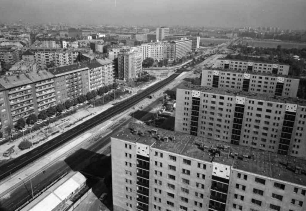
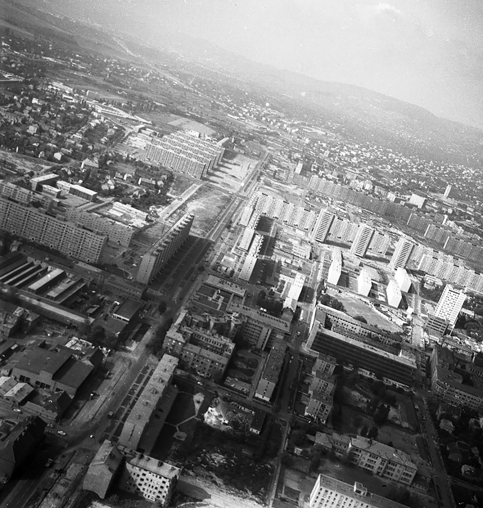
A milestone in Budapest’s housing estate development was the adoption of the prefabricated housing model, with the first housing estate built using this technology located in Kelenföld. From the late 1960s, housing estate construction gained momentum with the introduction of Soviet-inspired panel technology and the launch of the first prefabrication factories. Since housing policy at the time was characterized by a significant increase in the volume of construction large undeveloped areas were necessary for the rapid construction of large residential buildings using industrialized technology. Plans for Kelenföld included the construction of 10–15 thousand apartments, with the Kelenföld housing estate becoming part of the housing estate belt emerging in Budapest at the time.43
The road network of the housing estate was defined by the axes of the radial roads leading out of the city, such as Fehérvári, Szerémi, Budafoki streets, and the perpendicular Etele Street, which defined an orthogonal urban structure.44 The area was built up with modern slab and point blocks, mixing high with mid-rise buildings. Although some had previously advocated for taller buildings, by 1968, it became evident that construction exceeding ten stories resulted in disproportionately higher costs45. The master plan for the housing estate was prepared by Albert Kiss and Balázs Kovács (BUVÁTI), and the detailed development plan by József Finta and Zoltán Jakab (LAKÓTERV). Again using a mixture of high-rise and mid-rise tower and slab blocks, this area was given a modern city centre at the intersection of Tétényi and Szakasits Árpád Streets (Etele Streets). Sunlight exposure and the application of modern urban design principles were primary considerations in the planning. Although most of the stripe blocks were oriented east-west for optimal sunlight, some buildings along Etele Street were constructed parallel to the road, forming a continuous spatial boundary.46
However, the housing estate ignored several key elements of the previous master plans. Among the diagonal connections, the full development of Tétényi Street was omitted, leaving it to end abruptly at the Albertfalva estate. The planned extension of Bartók Béla Street past the railway was not realized, nor were the roads leading to the Kelenföld railway station, which were emphasized in the 1930s plan. As previously noted, the extension of Irinyi Street was also not realized in the Lágymányos housing estate, and its outer section, Bártfai Street, was only partially developed. Similarly, only segments of Hadak Street were completed in a southeast direction, notably failing to reach the railway station. Etele Street, which could have functioned as a ring road, also runs undirected into the square in front of the railway station at its western end, while on the eastern side, its continuation, the Hengermalom Street ends before reaching the Danube.
Moving outward along Fehérvári Street the housing estates of the Fehérvári Street, Hengermalom Street, Csorbai Street and Albertfalva were later built using similar prefabricated technology and principles as in Kelenföld. Between these housing estates, low-density garden city and condominium developments emerged. Meanwhile, an industrial zone developed on the eastern side of Fehérvári Street, where the noteworthy industrial buildings include the VERTESZ office building designed by Jenő Rimanóczy, and the Beloiannisz Telecommunications Factory designed by Lajos Arnóth and Jenő Szendrői.47 Thus, the area beyond the railway evolved into a distinctive patchwork of housing estates, garden city developments, and industrial zones.
As the last ones to be developed, the outlying areas therefore show perhaps the most significant difference from the original concepts. An uniformly orthogonal network has been built, the former diagonal roads and the representative squares at the nodes have been omitted or only partially finished; hence, ring-road situations could not be created. The large housing estates were primarily shaped by industrialised technologies, creating modern, open blocks; in their combination with the garden suburbs and industrial areas, they created a specific mixed-use area.
Conclusion
The issue of the centrality and continuity of urban rings emerges prominently both in the ideal plans and in the realization. As we can see in the first plans, the district was interpreted as an independent unit and the structure of the city was constructed from the geometric center of the area. In these plans, in addition to the networked basic structure, the classical ring and the organic spiderweb adaptions also appeared. The design process was influenced by a combination of traditional urban planning ideas, the early garden city concept and ideas pointing towards modernity. However, during the adaptation and implementation, Budapest’s ring-radius system had a strong influence on the direction of development, so the epicenter of the city district also moved to the north and, following Budapest trends, the district was built up in ring layers. Despite this, the planned ring roads did not become boulevards, while the recent cultural development of the diagonal Bartók Béla Street has taken on the name “Bartók Boulevard”. The morphological stratifications of the city, like the annual rings, also show this extensive growth in the radial direction. Moving from north to south, the layers depict the evolution of the morphological forms, which can also be used to outline the phases of modernity unfolding in the period.
This paper was supported by the János Bolyai Research
Scholarship of the Hungarian Academy of Sciences.
Domonkos Wettstein, Károly Zubek
Department of Urban Planning and Design
Faculty of Architecture
Budapest University of Technology and Economics
Műegyetem rakpart 3
H-1111 Budapest
Hungary
wettstein.domonkos@epk.bme.hu
zubek.karoly@edu.bme.hu
MEGGYESI, Tamás. 1985. A városépítés útjai és tévútjai. Budapest: Műszaki Könyvkiadó.
MEGGYESI, Tamás. 2009. Városépítészeti alaktan. Budapest: Terc.
SEIDL, Ambrus. 1993. A Szent Imre város története és szellemiségének kialakulása. Szentimreváros története 2. Budapest: Szentimrevárosi Egyesület; GERLE, János. 1999. A kerület építészete a századfordulón. In: Horváth, E. (ed.). A XI. kerület építészeti emlékei. II rész. XI. kerületi füzetek 5. sz. Budapest: Etele Helytörténeti Kör, Budapest XI. kerület, pp. 13–18; DÉRY, Attila. 2021. Házak, emlékek, alkotók. Építészettörténeti séta a Szentimrevárosban és környékén. Budapest: Ciszterci Diák és Cserkész Alapítvány.
PÁLFY, Sándor et. al. 2009. Egy tanszék 80 éve. A BME Urbanisztika Tanszékének története (1929–2009). Budapest: Terc.
PREISICH, Gábor. 2004. Budapest városépítésének története Buda visszavételétől a II. világháború végéig. Budapest: Terc.
KÖRNER, Zsuzsa. 2010. Városias beépítési formák: bérház- és lakástípusok. Budapest: Terc.
KÖRNER, Zsuzsa. 2015. A történeti városszövet megújulása 1870 és 1940 között. Budapest: BME Urbanisztika Tanszék.
For a detailed analysis of the settlement plans, see: Gerle, J., 1999, p. 14.
The regulation plan of the Kelenföld area, the plan marked A. Lipót Varásdy, 1868–1871. Inv. no. HU BFL XV.16.a.206/35b. Budapest City Archives.
The regulation plan of the Kelenföld area, plan C. Lipót Varásdy, around 1870. Inv. no. HU BFL XV.16.a.206/35a. Budapest City Archives.
Plan of Uj Buda in the Kelenföld area, plan marked D. Fővárosi Közmunkák Tanácsa (Patt, v. Adolf), 1870s. Inv. no. HU BFL XV.16.a.206/35c. Budapest City Archives.
Regulation plan of Buda, 1876. Inv. no. HU BFL XV.16.a.201/12 (1–229). Budapest City Archives.
Gerle, J., 1999, p. 14.
WETTSTEIN, Domonkos. 2018. Regional Strategies in Recreational Architecture along Lake Balaton (1929–1979) [online]. PhD thesis. Faculty of Architecture, BME Budapest. Available at: http://hdl.handle.net/10890/5623 (Accessed: 10 November 2024).
Pálfy, S. et. al., 2009.
FERKAI, András. 1999. A kerület építészete a két világháború között. In: Horváth, E. (ed.). A XI. kerület építészeti emlékei. II rész. XI. kerületi füzetek 5. sz. Budapest: Etele Helytörténeti Kör, Budapest XI. kerület, pp. 19–25.
FERKAI, András. 2006. A társasház, mint a budapesti lakóházépítés megújításának egyik módja. In: Ferkai, A. (ed.). Űr vagy megélt tér. Építészettörténeti írások. Budapest: Terc, pp. 103–123; NAGY, Ágnes. 2022. The Condominium Idea in the First Half of the 20th Century in Budapest. Architektúra & urbanizmus, 56(3–4), pp. 162–173. doi: 10.31577/archandurb.2022.56.3-4.3 For the layout of residential buildings, see Nagy’s studies on the website of the Budapest City Archives: NAGY, Ágnes. 2024. Connecting Courtyards and Enclosed Courtyards: The Limits of Development Reform on a City Block at Villányi Road [online]. Available at: https://habitation.archivportal.hu/en/themes/connecting-courtyards-and-enclosed-courtyards-limits-development-reform-city-block-villanyi (Accessed: 10 November 2024).
Urban design competition, Horthy Miklós Bridge area, perspective view. Inv. no. HU BFL XV.17.f.335/27. Budapest City Archives.
Regulation plan of Kelenföld, 1930. Inv. no. HU BFL XV.17.f.335/19. Budapest City Archives.
Gerle, J., 1999, pp. 13–18.
MÁRTONFFY, Melinda. 2020. Franciaudvaros bérházak Budapesten. Budapest: Artem Books; BOLLA, Zoltán. 2017. A magyar art deco építészet. II. rész. Budapest: Ariton.
Gerle, J., 1999, pp. 13–18.
Ferkai, A., 1999, pp. 19–25.
JÉKELY, Zsolt. 1999. A kerület építészete 1945 után. In: A XI. kerület építészeti emlékei. II rész. XI. kerületi füzetek 5. sz. Budapest: Etele Helytörténeti Kör, Budapest XI. kerület, pp. 26–33.
Ferkai, A., 1999, pp. 19–25.
Jékely, Zs., 1999, pp. 26–33.
WEINER, Tibor et al. 1954. Lakástervezésünk néhány kérdése. Magyar Építőművészet, 3(4–6), pp. 97–127.
Ferkai, A., 1999, pp. 19–25.
Jékely, Zs., 1999, pp. 26–33.
ARMUTH, Miklós and LŐRINCZI, Zsuzsa (eds.). 2013. Műegyetem – A történeti Campus. Budapest: Budapesti Műszaki és Gazdaságtudományi Egyetem.
Jékely, Zs., 1999, pp. 26–33.
KISS, Tibor. 1957. A Bocskai úti foghíjak beépítése. Magyar Építőművészet, 6(3–4), pp. 68–78.
Ferkai, A., 1999, pp. 19–25.
Jékely, Zs., 1999, pp. 26–33.
KOCSIS, János Balázs. 2009. Lakáspolitika Budapesten, 1950–1959. Múltunk Politikatörténeti Folyóirat, 54(3), pp. 83–122.
CSERBA, Dezső. 1956. A lágymányosi lakótelep. Magyar Építőművészet, 5(5), pp. 131–143.
FERKAI, András. 2005. Lakótelepek. Budapest: Budapest Fővárosi Önkormányzat Főpolgármesteri Hivatal.
Cserba, D., 1956, pp. 131–143.
Cserba, D., 1956, pp. 131–143
GYÖNGYÖSI, István. 1957. Budapest épülő új lakótelepei. Magyar Építőművészet. 6(1–2), pp. 18–19.
BRENNER, János and MESTER, Árpád. 1962. Budapesten építendő újabb lakótelepek városrendezési tervei. Magyar Építőművészet, 11(5), pp. 3–8.
SIPOS, András. 2005. Budapest városfejlesztési programja, 1930–1948. Múltunk – Politikatörténeti Folyóirat, 50(1), pp. 148–209.
KONDOR, Attila Csaba and SZABÓ, Balázs. 2007. A lakáspolitika hatása Budapest városszerkezetére az 1960-as és az 1970-es években. Földrajzi értesitö, 56(3–4), pp. 237–269.
ANTYPENKO, Hlib and BENKŐ, Melinda. 2022. Architectural and Urban Transformations of Large Housing Estate Related to Functional Diversification: Case of Kelenföld in Budapest. Journal of Architecture and Urbanism, 46(2), pp. 160–170.
Kondor, A. Cs. and Szabó, B., 2007, pp. 237–269.
KISS, Albert and KOVÁCS, Balázs. 1968. A kelenföldi lakótelep részletes rendezési terve. Magyar Építőművészet, 17(5), pp. 21–22.
Jékely, Zs., 1999, pp. 26–33.
DOI: https://doi.org/10.31577/archandurb.2023.57.3-4.3

This work is licensed under a Creative Commons Attribution 4.0 International License